
Strong rain and thunderstorms have been affecting parts of western Greece since yesterday, according to the updated severe weather advisory issued by the Hellenic National Meteorological Service (HNMS). The heaviest conditions are impacting the northern Ionian, Epirus, and sections of Aetolia-Akarnania.
HNMS warns that locally intense rain and thunderstorms will continue through Wednesday, with the focus on the northern Ionian—especially around Corfu and Paxos—as well as Epirus and the western and northern parts of Aetolia-Akarnania. In some areas, the storms will be accompanied by strong winds and possible hail.
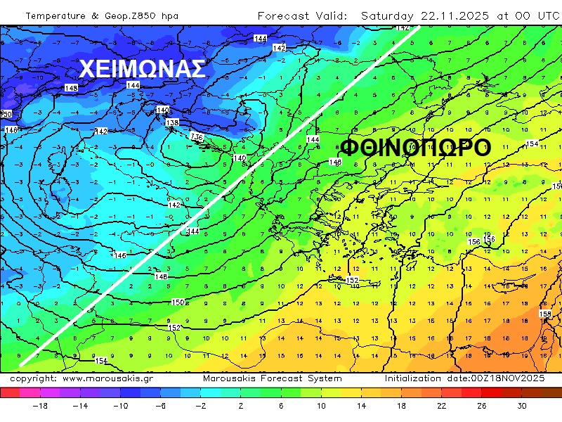
Meteorologist Klearchos Marousakis notes that a significant drop in temperatures is expected across much of Europe in the coming days, with a deep winter pattern also spreading into Greece. “Snow is likely to appear even in major European cities. Here in the eastern Mediterranean autumn is still holding on, but during the final third of the month we expect the first strong winter outbreaks, with snowfall first in the mountains and gradually at lower elevations,” he said.
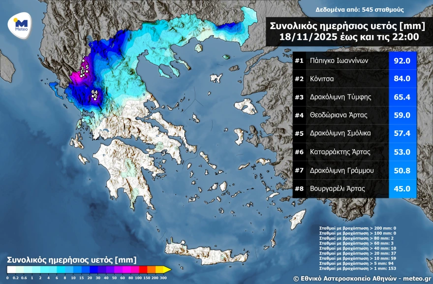
Ioannina records the heaviest rainfall
According to the National Observatory of Athens / Meteo.gr automatic weather station network, Epirus recorded the largest rainfall totals, with Papigo in Ioannina topping the list at 92 mm by 22:00 on Tuesday.
Extremely severe conditions were also reported around the three alpine lakes of northern Pindus—Gramos, Tymfi, and Smolikas—where wind gusts exceeded 100 km/h, accompanied by heavy rain.
Lightning strike in Ioannina
Torrential rain and strong winds struck Ioannina and Thesprotia on Tuesday evening. In the Ambelokipoi district of Ioannina, a lightning bolt hit the roof of a three-storey building at around 9:30 p.m., blowing a large hole in the structure. Roof tiles shattered and were thrown across the area. Fire crews responded immediately, confirming that the concrete slab beneath the roof remained undamaged.

Road problems in Konitsa – Tree collapse in Igoumenitsa
In the Konitsa area, heavy rainfall triggered small landslides and debris flows, causing problems on mountain roads. A pickup truck with two occupants became trapped but both were safely escorted away by firefighters. Municipal crews were dispatched to clear the road.
In Igoumenitsa, strong winds uprooted a large plane tree along the seafront, sending it crashing onto a restaurant awning and nearby balconies. The incident caused material damage but no injuries.
Today’s Weather
Rain and thunderstorms are expected in the Ionian Sea, the western mainland, northern Macedonia, Thrace, and the southern Peloponnese. Elsewhere, clouds will linger with occasional light showers. Dust concentrations in the atmosphere will remain elevated.
Temperatures:
- Western Macedonia: 7–17°C
- Rest of Macedonia & Thrace: 12–20°C
- Thessaly: 9–20°C
- Epirus & western Central Greece: 13–20°C
- Eastern Central Greece: 12–21°C
- Peloponnese: 7–22°C
- Ionian Islands: 17–21°C
- Northern/Eastern Aegean Islands: 13–20°C
- Cyclades: 17–20°C
- Dodecanese: 16–21°C
- Crete: 10–21°C
Winds: Southerlies at 4–6 Beaufort at sea.
Attica: Cloudy with a chance of brief, light showers. Winds southerly 2–4 Beaufort, temperatures 18–20°C in central Athens.
Thessaloniki: Mostly cloudy with the possibility of light showers. Winds from the east to southeast up to 3 Beaufort, temperatures 17–20°C.
Forecast
Thursday, 20 November
Rain and isolated thunderstorms in the Ionian, Epirus, western Thessaly, and western Central Greece—locally strong until midday. Cloudy with patchy rain in Macedonia, Thrace, and the eastern Aegean. Elsewhere, variable cloud. African dust will continue to affect much of the country.
Winds southerly 4–6 Beaufort, up to 7 Beaufort in the northern Aegean early and 7–8 Beaufort in the Ionian from afternoon.
Temperatures steady: 18–20°C north, 21–23°C elsewhere, 24°C in the south.
Friday, 21 November
Increasing cloud, especially in the west, north, and eastern Aegean, with local rain and isolated storms in the northern Ionian. African dust may persist in central and southern regions.
Southerly winds 5–6 Beaufort, locally 7 Beaufort in the Ionian.
Temperatures will rise slightly in central and southern Greece.
Saturday, 22 November
Thicker cloud in the west, north, and eastern Aegean with scattered rain; thunderstorms in the northern Ionian. Partly cloudy elsewhere.
Southerly winds 4–6 Beaufort, up to 7 Beaufort in the Ionian and southeastern Aegean.
Temperatures unchanged.
Sunday, 23 November
Unsettled weather in the west with rain and isolated thunderstorms. Cloud and local showers in the north and eastern Aegean. Snow expected over the mountains of Epirus and Macedonia.
Southerly to southwesterly winds 4–5 Beaufort, 6 Beaufort at sea.
Temperatures will drop sharply in the west and north, with a more moderate decline elsewhere.
Ask me anything
Explore related questions