The National Weather Service has issued an emergency weather advisory for bad weather “Adel”, which from today, Wednesday 26 November begins to affect much of Greece with heavy rain, thunderstorms and gusty winds, with the phenomena peaking on Thursday and Friday.
Schools and municipal kindergartens in central and southern Corfu will be closed today following a decision by the municipalities due to bad weather. The University on the island will also remain closed. Yesterday afternoon, the coordinating body of both the municipality and the region met after the forecast for severe weather expected to occur on the island.
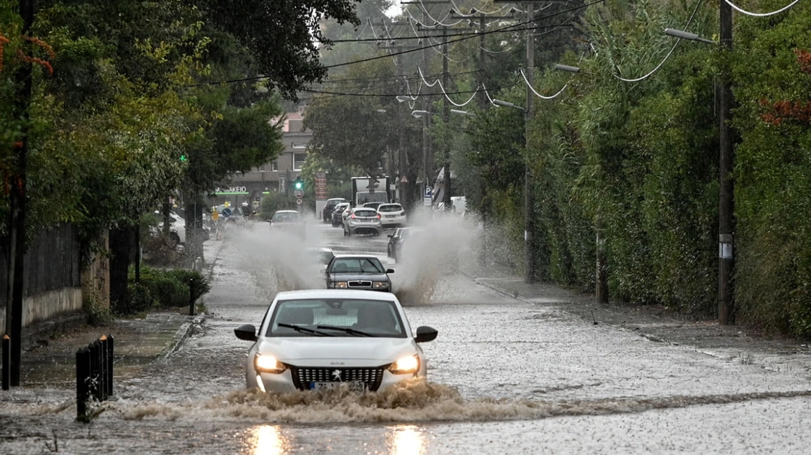
Severe weather from today – Which areas are affected
Already since Tuesday, heavy rain and thunderstorms have occurred in western and northwestern Greece, with EMY warning that today, Wednesday, the phenomena will intensify further as the “Adel” bad weather extends further east. According to meteorologist Thodoris Kolydas, from the morning to midday strong storms are expected in Corfu, Diapontius, Paxos and Epirus, while from the afternoon intense phenomena will hit Lefkada, Kefalonia, Ithaca, Zakynthos, Aitoloakarnania and the western and southern Peloponnese. From the evening, strong thunderstorms are forecast in eastern Macedonia. As Mr. Kolydas points out, Wednesday is the transitional stage before the peak of the bad weather.
Meteorologist Giannis Kallianos says “Adel” will affect almost the entire country, especially the Ionian Sea, Epirus, the western and southern Peloponnese, eastern Macedonia, Thrace and the eastern Aegean. It adds that Attica, as well as Thessaloniki, will also receive intermittent thunderstorms until Saturday, with estimated rainfall totals of 70-90 mm and 100-120 mm respectively. At the same time, it warns of a high probability of flooding phenomena, especially on the Ionian Islands, in western Greece and in areas of eastern Macedonia – Thrace.
Thursday is expected to be the most difficult day of bad weather, as “Adel” will cause widespread thunderstorms, heavy rainfall, local hailstorms and very strong southerly winds. The areas that will receive the most intense phenomena are the Ionian Islands, Epirus, western and central Sterea, western and southern Peloponnese, central and eastern Macedonia, Thrace, eastern Aegean, Dodecanese, Cyclades and Crete. Winds will blow south 4-6 Beaufort, gradually reaching 7 Beaufort in the Aegean and early in the morning even 8 Beaufort in the Thracian.
On Friday, showers and sporadic thunderstorms will occur almost all over the country. In western Greece, the phenomena will be strong from the night to the morning hours, while then intense thunderstorms will affect central and eastern Macedonia, Thrace and the eastern Aegean. Occasional snowfall is forecast in the highlands of Epirus, Macedonia, Thessaly and western Sterea. The temperature will drop slightly, while winds will reach 7 Beaufort in the sea.
Yannis Kallianos, presenting the predicted rainfall for the four days, estimates that 200-250 mm will be recorded in the Ionian Sea, 150-170 mm in Epirus, 160-180 mm in the western and southern Peloponnese, 200-250 mm in eastern Macedonia and Thrace and 200-220 mm in the eastern Aegean. 70-90 mm are expected in Attica and 100-120 mm in Thessaloniki.
At the same time, it notes that areas such as Corfu, Paxos, Lefkada, Ithaca, Kefalonia, Zakynthos, parts of Thesprotia, Aitoloakarnania, Ilia, Messinia and Laconia, as well as zones in Halkidiki, Serres, Drama, Kavala, Xanthi, Rodopi and islands of the eastern Aegean are at increased risk of flooding. The possibility remains for Attica and Thessaloniki.
In its emergency bulletin, the EMY confirms that the Adel system will continue to produce heavy rain and thunderstorms on Thursday and Friday, accompanied by very strong winds and localized hail. Starting Sunday, the system is expected to move eastward, allowing for a gradual improvement in weather.
Red warning
Today Wednesday (26-11-25) heavy showers and thunderstorms are forecast:
a. On the Ionian islands of Corfu, the Intercontinental Islands and Paxos and in Epirus.
β. From the afternoon in Lefkada, Kefalonia, Ithaca, Ithaca, Zakynthos, Aitoloakarnania, western and southern Peloponnese.
c. From the evening in eastern Macedonia.
The weather system called ADEL will cause heavy rain and thunderstorms on Thursday (27-11-25) and Friday (28-11-25), accompanied by local hail and occasionally very strong winds, in many areas of western and northern Greece and the eastern Aegean.
More specifically:
On Thursday (27-11-25) heavy rain and thunderstorms are forecast:
In the Ionian Islands, Epirus, western and central Sterea, western and southern Peloponnese, central and eastern Macedonia and Thrace.
On Friday (28-11-25) heavy rain and thunderstorms are forecast in central and eastern Macedonia, Thrace, eastern Aegean and until early morning in western Greece.
Frost on the mainland on Tuesday morning 25/11 – Temperature at -2.2 °C in Fort Nefrokopi
Negative minimum temperatures were recorded in the morning hours of Tuesday 25/11 in places on the mainland, with the lowest minimum temperature recorded in Fort Nefrokopi at -2.2 °C.
Today’s weather
Initially heavy rain and thunderstorms will occur from the beginning of the day in Corfu, Paxos and areas of Epirus. Progressively the phenomena will extend to the whole western part of the country and to areas of Eastern Macedonia and Thrace. The storms will be accompanied by hail in places, mainly in the west. Local showers or thunderstorms of lesser intensity are also expected in areas of the Peloponnese, Sterea, Cyclades and the islands of the eastern Aegean.
The temperature will range in Western Macedonia from 3 to 15 degrees Celsius, in the rest of Macedonia and Thrace from 6 to 17-19 degrees Celsius, in Thessaly from 6 to 20-22 degrees Celsius, in Epirus from 10 to 17-19 degrees Celsius, in the rest of the mainland from 11 to 20-23 degrees Celsius, in the Ionian Islands from 14 to 17-19 degrees Celsius and in the Aegean Islands and Crete from 12 to 20-22 degrees Celsius.
In the Aegean Sea, winds will blow from the south with intensities of 5-6 Beaufort. In the Ionian Sea, southerly winds will blow from the south, also with intensities of 5-6 Beaufort, but in the evening they will turn to southwest and weaken slightly.
In the prefecture of Attica and the city of Athens we expect clouds, with the possibility of occasional light rain mainly during the morning and afternoon hours. Winds will blow from southern directions with 4-5 Beaufort winds. The temperature will range from 15 to 19-20 degrees Celsius.
In Thessaloniki we expect clouds with showers from the afternoon. The winds will blow southeast with intensities of 3-5 Beaufort. The temperature will range from 13 to 19 degrees
The weather on Thursday, November 27
On the islands of the eastern Aegean, the Dodecanese, the Cyclades and Crete, intermittent clouds with local rain mainly on the islands of the eastern Aegean, where it will intensify at night. In the rest of the country rain and occasional thunderstorms. The phenomena on the Ionian Islands, Epirus, western and central Sterea, western and southern Peloponnese, central and eastern Macedonia and Thrace will be particularly strong in places and will be accompanied by local hail and occasionally by very strong winds.
Winds will blow from southern directions 4 to 6, in the southern Ionian and Aegean Sea locally 7 and in the morning hours in Thrace possibly 8 Beaufort.
and in the morning and in the afternoon it may be possible to get some winds and in some parts of the day it may be possible to get winds of up to 8.5 to 8.5 hours.
The temperature will drop slightly, mainly in the northwest. It will reach 17 to 19 degrees Celsius in the northern mainland and the Ionian Sea, 19 to 21 degrees Celsius in the rest of the mainland and 22 to 23 degrees Celsius in the eastern and southern islands.
The weather on Friday, November 28
Cloudy with showers and occasional thunderstorms in most parts of the country. The phenomena in central and eastern Macedonia, Thrace, eastern Aegean and until early in the morning in western Greece will be particularly strong in places and will be accompanied by local hail and at times by very strong winds. Occasional snowfall will occur in the mountains of Epirus, Macedonia, Thessaly and western Sterea.
Winds will blow from southerly directions, in the west 3 to 5, in the east and south 5 to 6 and in the sea locally 7 Beaufort.
The temperature will drop slightly in most of the country.
The weather on Saturday, November 29
Unsettled weather with partly cloudy skies and local showers in most of the country. In the eastern Aegean and the Dodecanese there will be sporadic thunderstorms.
Winds will blow in the west from the north from 3 to 5 Beaufort. In the east it will initially blow from southerly directions 4 to 6 Beaufort, turning from noon to west northwest with the same intensity.
The temperature will drop slightly further, mainly in the central and northern regions.
The weather on Sunday, November 30
In the eastern Aegean a few clouds, partly increasing with local showers and in the early morning hours isolated thunderstorms. In the rest of the country a few clouds, partly increasing with a possibility of light local rain in the west.
Winds will blow northwest at 3 to 5 Beaufort.
The temperature will not change significantly.
Civil Protection recommendations in view of the bad weather
In particular, in areas where heavy rainfall, thunderstorms or gusty winds are predicted, the GIS recommends that citizens:
– Secure items that may cause damage or injury if carried away by severe weather.
– Ensure that residential gutters and downspouts are unclogged and functioning properly.
– Avoid crossing streams and creeks, on foot or by vehicle, during storms and rainstorms and for several hours after they have ended. Particular attention needs to be paid at the points of the road network where the road crosses torrents and there is no bridge.
– Avoid outdoor work and activities in marine and coastal areas during the outbreak of severe weather events (risk of lightning strikes).
– Take shelter immediately during a hailstorm. Take shelter in a building or car and do not leave the safe area until they are sure the storm has passed. Hail can be very dangerous for animals as well.
– Avoid crossing under large trees, under posted signs, and generally from areas where light objects (e.g., pots, broken glass, etc.) can become detached and fall to the ground (e.g., under balconies).
If you are at home
– Do not hold electrical appliances or phone because lightning can pass through wires. Disconnect television sets from the antenna and power supply.
– Avoid touching plumbing pipes (kitchen, bathroom) as they make good conductors of electricity.
If you are in the car
– Park it on the side of the road and away from trees that may fall on it.
– Stay inside and turn on the warning stop lights (emergency lights) until the storm subsides.
– Close windows and do not lean against metal objects.
– Avoid flooded streets.
If you are outdoors
– Take shelter in a building or car otherwise sit on the ground immediately without lying down.
– Take shelter under solid branches of low trees in case you are in a forest.
– Never shelter under a tall tree in an open area.
– Avoid low ground for the risk of flooding.
– Do not stand next to pylons, power lines, telephone lines and fences.
– Do not approach metal objects (e.g., cars, bicycles, camping equipment, etc.).
– Stay away from rivers, lakes or other bodies of water.
– If you are in the water get out immediately.
– If you are isolated on a flat area and feel your hair stand up (indicating that lightning will soon occur), sit deep with your head between your legs (to minimize your body surface and contact with the ground), throwing away any metal objects you have on you.
For information and announcements regarding the prevailing situation and the passability of the roadway network due to floodwaters entering the network, citizens can visit the Hellenic Police website at www.astynomia.gr.
For more information and instructions on self-protection from severe weather phenomena, citizens can visit the website of the Ministry of Climate Crisis and Civil Protection at civilprotection.gov.gr.
Ask me anything
Explore related questions