The bad weather system “Adel” is expected to strike a large part of Greece today, with Civil Protection on “red alert,” as heavy rain and thunderstorms are already occurring in several regions, causing problems in Western Greece. Successive waves of storms swept across Attica throughout the night, with rain continuing into the morning and reports of hail in some parts of the capital.
The rain has also caused problems for road circulation, with Piraeus Street closed for a short time at the level of Chamosterna.
By just before 7:30 a.m., the fire department had received 35 calls for tree removals in Attica.
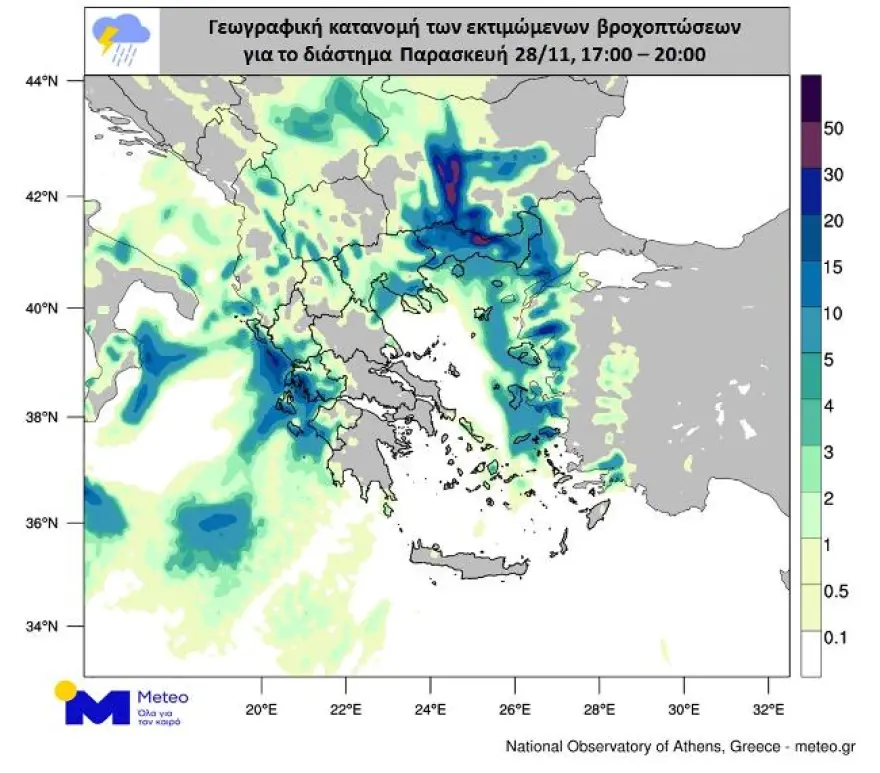
Meteorologist Thodoris Kolydas published maps showing the areas expected to be most affected by intense hailstorms and cumulative rainfall for today, Friday.
The intense weather phenomena began in the early morning hours, with large amounts of rain, strong thunderstorms, and incidents of hail. According to the latest forecast from the National Observatory of Athens, today is characterized by a high probability of large-sized hail, even in Attica, while the rainfall episode is classified as Category 4, meaning “very significant.” Snowfall is recorded in mountainous areas of Western, Central, and Northern Greece.
Severe weather continues – heavy rain, thunderstorms, and hail
According to the forecasting data from meteo.gr / NOA, today, Friday 28/11, the bad weather will continue with heavy rain and thunderstorms, large rain accumulation in places, and hailstorms with a chance of large hail.
More specifically:
On Friday 28/11, locally strong rain and thunderstorms are expected in Western Greece, Central Greece, the Peloponnese, Central and Eastern Macedonia, Thrace, and parts of Thessaly and the Sporades. Similar phenomena will affect the islands of the Northern and Eastern Aegean and the Cyclades from midday, and by evening the Dodecanese and Crete. Hailstorms will occur mainly in the Peloponnese, Eastern Central Greece—including Attica—and gradually in the Aegean islands. In some areas the hail may be large. Snow will fall in the mountainous regions of western, central, and northern Greece.
The rainfall episode is classified as Category 4 (Very Significant).
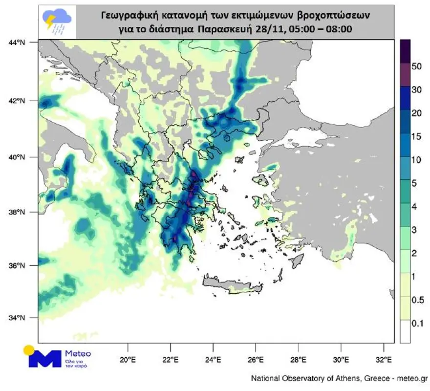
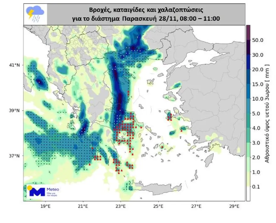
Forecast maps for the intervals Friday 27/11, 05:00–08:00; Friday 28/11, 08:00–11:00; and Friday 28/11, 17:00–20:00 show the geographic distribution of the expected phenomena, with more intense colors indicating stronger events.
Emergency Weather Bulletin from the HNMS
The Emergency Bulletin of Dangerous Weather Phenomena is updated with the latest forecast data.
A weather system named ADEL will affect almost the entire country today, Friday (28-11-25), with rain and thunderstorms. The phenomena in many parts of western and northern Greece, as well as the eastern Aegean, will be strong and accompanied by local hailstorms and occasionally very strong winds.
More specifically:
On Friday (28-11-25), strong rain and thunderstorms are forecast:
a. in Eastern Macedonia, Thrace, and until the afternoon in the regional units of Halkidiki, Serres, Kilkis, and Thessaloniki
b. in the Ionian Islands and western and southern Peloponnese until the morning hours
c. in the Eastern Aegean islands from midday
d. in the Dodecanese from the evening hours.
Four regions in “red code,” the critical 12 hours
Heavy rain and thunderstorms are already affecting Western Greece, Central Greece, the Peloponnese, Thessaly, Central and Eastern Macedonia, Thrace, and the Sporades, while from midday the phenomena will extend to the Northern and Eastern Aegean and the Cyclades. Toward evening, the weather system is expected to affect the Dodecanese and Crete. Strong hailstorms are recorded in the Peloponnese, Eastern Central Greece, and parts of Attica, in some cases with large-sized hail.
Preparations of the state mechanism were completed on Thursday after a meeting of the Risk Assessment Committee convened by the General Secretary for Civil Protection, Nikos Papaefstathiou. The Ministry of Climate Crisis and Civil Protection has placed Eastern Macedonia, Thrace, the Northern Aegean, and the Dodecanese under “red code,” while the regions of the Ionian Islands, Epirus, Western Greece, the Peloponnese, Central Macedonia, and Eastern Macedonia & Thrace remain on alert. The Unified Coordination Center for Operations and Crisis Management is in constant communication with local authorities, and all Civil Protection Councils have been held to ensure immediate response.
Double passage over Attica on Friday
According to Thodoris Kolydas, on Friday morning the western and southern Peloponnese as well as Eastern Macedonia and Thrace will be affected, with the meteorologist warning especially about Thasos. He notes that “Attica will see two rounds of phenomena, one during the night and another after dawn on Friday.”
On Friday afternoon the bad weather will hit Eastern Macedonia–Thrace and the Eastern Aegean, with particular attention needed for Chios, Samos, and Ikaria. Phenomena in these regions will continue into the night and will affect the Dodecanese as well. From Saturday morning to midday, the focus shifts to the Dodecanese and weakening will begin.
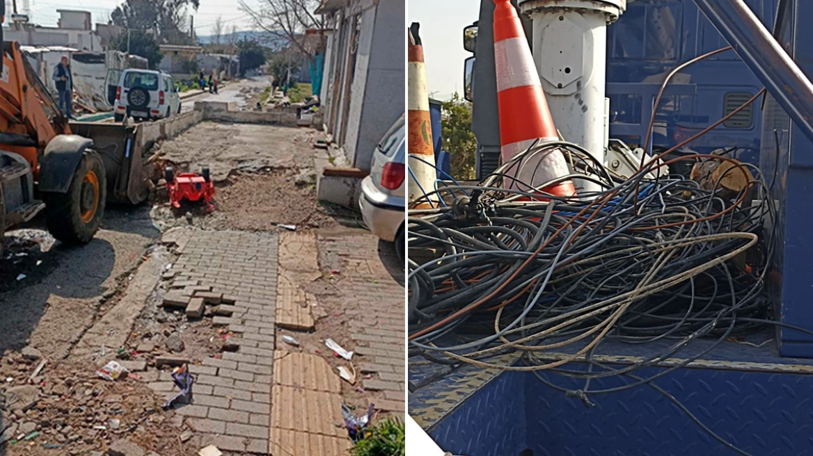
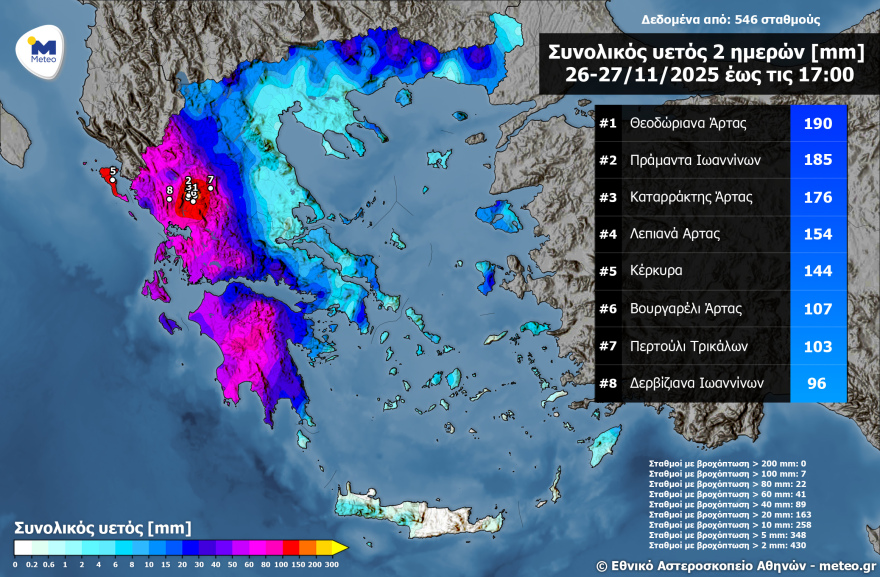
Arta recorded the highest rainfall yesterday
On Thursday, heavy rain and thunderstorms occurred in the Ionian Islands, Epirus, Aetolia-Acarnania, western and southern Peloponnese, Eastern Macedonia, Thrace, and the regional units of Halkidiki, Serres, Kilkis, and Thessaloniki. Indicative of the severity of the phenomena are the rainfall data published by Meteo.
As seen on the map, according to the network of meteo.gr / National Observatory of Athens, rainfall exceeded 100 mm at 7 stations, 80 mm at 22 stations, and 60 mm at 41 stations.
Floods and hail
Flooding occurred on Thursday in the port of Agia Kyriaki in Zola, Kefalonia, with roads becoming impassable, as shown in a video by Kefalonia Focus.
Intense hail also struck the area of Mandra, Xanthi, while in Amfilochia a stream overflowed.
Homes “up in the air” in Tzoumerka
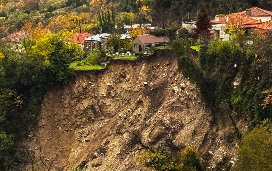
Meanwhile, a landslide occurred in the village of Agnanta in Tzoumerka due to continuous heavy rainfall. As the governor of Epirus, Alexandros Kachrimanis, told protothema.gr, regional crews have “diverted the flow of water” away from the Tzoumerka villages, while specialized geologists are already in the area with the primary goal of preventing further damage.
In Thesprotia, the plain of Paramythia turned into a vast lake, with animals seeking food in flooded fields, according to artinos.gr. In Parapotamos, residents are counting their losses, as the bad weather caused extensive damage to crops and property. Strong winds caused damage to businesses, splitting trees that then swept away structures.
On Meganisi in Lefkada, roads and homes flooded. A municipal crew using the civil protection vehicle is attempting to pump water from homeowners’ yards, according to ilefkada.gr.
Tornado in Finikounda
“Adel” also struck Messinia hard late Wednesday night, causing extensive damage. The most intense phenomena appeared early Thursday morning when a severe hailstorm was accompanied by a sudden shift in winds—from southerly to strong westerly.
In Finikounda and particularly in the Mavrovouni area, businesses and homes sustained damage; windows shattered, and roofs and awnings were torn off.
Weather for Saturday, November 29
Clouds, occasionally increased, with local showers over most of the country. Scattered thunderstorms in the Ionian Islands, Eastern Macedonia, Thrace, the Cyclades, Crete, the Eastern Aegean islands, and the Dodecanese. The phenomena—locally strong in the Eastern Aegean and the Dodecanese—will gradually weaken from midday. Visibility will be locally reduced in the mainland during morning and evening hours.
Winds: In the west, northwesterly 3–5 Beaufort, locally 6 in the Ionian. In the east, southerly 4–6 Beaufort shifting in the afternoon to west-northwest winds 4–5 Beaufort.
Temperature: A slight further drop across the country. Highs of 14–16°C in the Ionian and mainland, 17°C in parts of eastern mainland, and 18–20°C in the eastern and southern island regions, locally 21°C in the Dodecanese.
Weather for Sunday, November 30
In the Eastern Aegean: partly cloudy with intermittent showers and isolated thunderstorms until midday.
Elsewhere: a few clouds, occasionally increased, with a chance of light local showers in the west and south until the afternoon. Visibility will be locally reduced in the mainland during morning and evening hours.
Winds: Northwesterly 3–4 Beaufort, in the southern Aegean 5–6.
Temperature: No significant change.
Ask me anything
Explore related questions