
Severe Weather Expected in Greece: Two Successive Systems to Bring Heavy Rainfall
A period of significant rainfall is expected to affect Greece and the wider Eastern Mediterranean in the coming days, according to meteorologist Thodoris Kolydas. Two consecutive weather disturbances will impact the country over a three-day period.
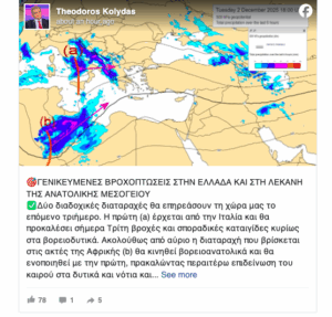
The first system, moving in from Italy, will bring showers and isolated thunderstorms today, Tuesday, mainly in the northwest. Beginning tomorrow, a second disturbance—currently located off the coast of Africa—will move northeast and merge with the first, leading to a marked deterioration of weather in the west and south, and eventually across most of the country by Thursday.
Kolydas adds that from Friday onward, unstable weather will persist not only in Greece but throughout the Eastern Mediterranean, with heavy rainfall also expected in Cyprus.
“Difficult Days Ahead,” Experts Warn
Meteorologist Giorgos Tsatrafyllias also highlights the severity of the upcoming system, noting that “Thursday and Friday are the difficult days.” He presented early forecast maps indicating regions where storm surges and persistent heavy rainfall may trigger problems during the critical 48-hour window.
He warns that the system will produce hail, strong southerly winds, and snowfall in mountainous areas.
According to Tsatrafyllias, the weather shift begins tonight, starting in the west due to a mild disturbance. By tomorrow, rain will spread to western Greece, Crete, and much of the mainland, except for Thrace. These first rains are not expected to cause major issues, though he expresses slight concern for the Ionian Islands.
Looking ahead to the weekend and Monday, as the African low-pressure system moves toward Cyprus, Tsatrafyllias anticipates no major problems, noting that the situation will be reassessed closer to the time.
Weather Forecast for Tomorrow
- Eastern Macedonia, Thrace, the Cyclades, and the eastern Aegean islands: Cloudy skies, with local showers developing in the Cyclades from the evening.
- Rest of the country: Increasing cloudiness, with showers in the Ionian Sea, the western mainland, and gradually the central and eastern mainland and Crete.
- Thunderstorms are most likely in the Ionian, the western coastal regions, and possibly the southern Peloponnese and southern Crete.
- Intense rainfall is likely on the Ionian islands.
Additional Conditions
- Snow: Expected in the mountains of Epirus and Macedonia.
- African Dust: Weather conditions may bring African dust to parts of the west and south from the evening.
- Visibility: Locally reduced in the morning on the mainland.
- Winds: East to southeast, 3–5 Beaufort; 4–6 Beaufort in the Ionian; increasing locally to 7 Beaufort by evening.
- Temperature: Little change expected.
- 14–16°C northern mainland
- 16–18°C Ionian, northern Aegean & central/southern mainland
- 19–21°C southern islands
Ask me anything
Explore related questions


