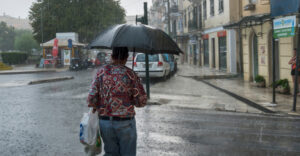
Greece is expected to be hit by a widespread 72-hour spell of severe weather, starting early Thursday and lasting through Saturday, with heavy rain, thunderstorms, and very strong winds, according to forecasts by the Hellenic National Meteorological Service (EMY) and assessments by meteorologists Giorgos Tsatrafilias and Giannis Kallianos. Experts emphasize the heightened likelihood of flooding in several regions and note that Attica is at particular risk due to its limited ability to absorb water.
Meteorologist Giorgos Tsatrafilias reports that the bad weather system arriving from the west at dawn on Thursday will affect the entire country. “Nationwide severe weather with strong thunderstorms and continuous rainfall for 72 hours,” he warns, highlighting the increased danger of flooding and landslides across large parts of Greece.
He adds that rainfall totals may reach extreme levels in Pelion, Volos, Larissa, and Pieria, while in Attica the problem is less about rainfall volume and more about the fact that the region “now has very limited natural drainage due to urbanization.”
Meteorologist Giannis Kallianos explains that the severe weather expected from Thursday through Saturday will be caused by a well-organized low-pressure system bringing widespread rain and thunderstorms across much of the country.
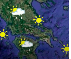
“A weather system is coming — no need for panic,” he notes, clarifying that winds will be especially strong, reaching 7–8 Beaufort and locally 9 Beaufort in gusts, especially over the seas and coastal areas. According to his mapping, the most intense phenomena are expected in the Ionian Islands, Western Epirus, Western and Southern Peloponnese, Eastern and Northeastern Peloponnese, Attica, Boeotia, Evia, parts of the Sporades, Halkidiki, Pieria, Imathia, areas of Larissa, Magnesia, parts of the Cyclades, the Eastern Aegean islands, the Dodecanese, and Western and Southern Crete.
Kallianos notes that possible impacts include sudden flash floods in small streams or uncleared areas, urban flooding due to restricted drainage, road network disruptions, local landslides, power outages caused by lightning or strong winds, and temporary coastal flooding from storm surge.
He stresses the need for the state to maintain heightened readiness — clearing drains and streams, informing residents early, patrolling high-risk areas, coordinating with local authorities, and ensuring protection for schools, hospitals, and vulnerable groups. He also emphasizes the importance of temporarily restricting access to dangerous areas where weather conditions are expected to worsen.
For citizens, Kallianos urges caution but not fear. He advises avoiding unnecessary travel during heavy rainfall, staying away from streams, not attempting to cross flooded roads, avoiding parking under trees, and always following official instructions.
In closing, he reminds that disaster management depends not only on weather forecasting but also on infrastructure resilience. Effective preparation requires continuous monitoring of critical locations, updating emergency plans, and rapid mobilization when necessary. While weather events cannot be prevented, risk can be reduced and communities protected through scientific and strategic planning.
Detailed Forecast for Wednesday (EMY)
Eastern Macedonia, Thrace, Eastern Aegean Islands, Dodecanese:
Scattered clouds becoming denser; possible light rain in the Dodecanese.
Elsewhere: Increased cloudiness with rain across western Greece and gradually in other areas.
Scattered thunderstorms mainly in the Ionian and western coastal zones, and from afternoon in southern Peloponnese and Crete. Localized intense phenomena possible in the Ionian Islands and later in southern Peloponnese and southern Crete.
Morning visibility locally limited on the mainland.
Winds: E/SE 3–5 Beaufort, 5–6 in the Ionian, locally 7 in the afternoon.
Temperature: 12–20°C depending on region.
Regional summaries are translated exactly as presented (you can ask for them in condensed form if you prefer).
Weather for Thursday, December 4
In Thrace, scattered clouds at times thicker. Elsewhere, rain and isolated thunderstorms mainly in coastal areas. Phenomena may be locally strong in Central Macedonia, eastern mainland, the Sporades, and Evia.
Winds: E/SE 4–6 Beaufort, 7 in the Ionian and later in central and southern Aegean.
Temperature: Slight rise, up to 22°C in southern regions.
Weather for Friday, December 5
Rain and thunderstorms locally strong in Central Macedonia, eastern mainland, the Sporades, Evia, the Cyclades, Crete, the Eastern Aegean islands, and the Dodecanese. Elsewhere, unstable weather with occasional showers and isolated storms.
Snow expected in mountainous areas of Western & Central Macedonia and Epirus.
Winds: E 4–6 Beaufort, up to 7–8 in the Aegean; turning NW 3–5 Beaufort in the west.
Temperature: Slight drop in western and southern Greece.
Weather for Saturday, December 6
Clouds with rain and coastal thunderstorms — locally intense — in central and northern mainland, southern Ionian, and northern/eastern Aegean. Gradually affecting the Cyclades and Crete.
Elsewhere, locally increased clouds with brief showers; light snow in central and northern mountains.
Winds: Variable 2–4 Beaufort in the west, turning NW; southern winds 3–5 Beaufort in the east and 6 in the Aegean.
Temperature: Slight drop, mainly in southern Greece.
Ask me anything
Explore related questions