
A new wave of severe weather is expected to affect a large part of the country from today through Thursday, according to the forecast by the Hellenic National Meteorological Service (EMY). During yesterday’s meeting of the Risk Assessment Committee, held in the context of the Emergency Weather Warning Bulletin, five regions were placed under “Red Alert” (Red Code).
Five Regions on Red Alert
Epirus, the Ionian Islands, the Peloponnese, Macedonia, and Thrace are among the areas expected to be hit by intense weather phenomena. Civil Protection authorities have issued recommendations urging citizens to exercise increased caution and to limit non-essential travel.
Specifically, the Red Alert will be in effect on Tuesday and Wednesday for Western Greece, Epirus, and the Ionian Islands, while from Wednesday through Thursday it will extend to Eastern Macedonia–Thrace and the Peloponnese.
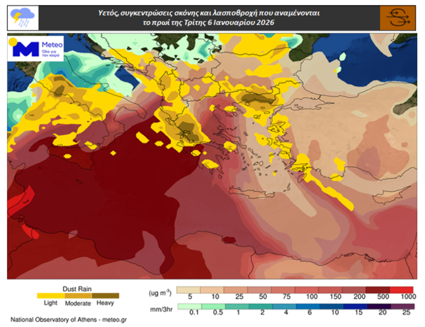
Saharan Dust and Mud Rain
Atmospheric circulation over Europe and North Africa is favoring the transport of Saharan dust toward Greece, due to prevailing southerly winds in the middle and lower troposphere. This situation is not expected to change significantly until Thursday, January 8.
As a result, elevated dust concentrations in the atmosphere are expected, along with mud rain in several areas.
Forecast by meteo.gr
According to the latest forecast data from the National Observatory of Athens / meteo.gr, mud rain will occur until the early hours of Wednesday, January 8, mainly in western, northern, and northeastern Aegean regions. The phenomena will then spread to other parts of the country.
From Thursday morning, mud rain will be confined to the Southern and Eastern Aegean as well as Crete, gradually weakening and fully ending by Thursday evening.
The accompanying map highlights in yellow and brown the areas where localized mud rain is expected on Tuesday morning, January 6.
Emergency Weather Bulletin Issued by the EMY
Heavy rain and thunderstorms are forecast from the early morning hours of Tuesday (06-01-26) through the morning hours of Thursday (08-01-26) across most areas of western and northeastern Greece.
It is noted that rainfall will not only be intense but also long-lasting. In many areas, severe phenomena may be accompanied by localized hailstorms and strong winds reaching 8 to 9 Beaufort.
Specifically, locally heavy rain and thunderstorms are forecast:
On Tuesday
- Ionian Islands (mainly Corfu, Lefkada, Kefalonia)
- Epirus (mainly Thesprotia, Preveza, Arta in the west, and western Ioannina)
- Western Central Greece (mainly Aetolia-Acarnania)
- Eastern Macedonia and Thrace from the afternoon hours (orange warning)
On Wednesday
- Ionian Islands (mainly Corfu, Lefkada, Kefalonia)
- Epirus (mainly Thesprotia, Preveza, Ioannina, Arta)
- Western Central Greece (mainly Aetolia-Acarnania)
- Western and southern Peloponnese from the afternoon until late at night (orange warning)
- Eastern Macedonia and Thrace until late at night (orange warning)
From the morning hours of Thursday, the intense phenomena are expected to gradually weaken. However, unsettled weather will persist in most areas of the country, with varying local characteristics.
⚠️⚠️⚠️ΕΚΤΑΚΤΟ ΔΕΛΤΙΟ ΕΠΙΚΙΝΔΥΝΩΝ ΚΑΙΡΙΚΩΝ ΦΑΙΝΟΜΕΝΩΝ (ΚΟΚΚΙΝΗ ΠΡΟΕΙΔΟΠΟΙΗΣΗ )
— Theodoros Kolydas (@KolydasT) January 5, 2026
Ισχυρές βροχές και καταιγίδες προβλέπονται από τις πρώτες πρωινές ώρες της Τρίτης (06-01-26) έως και τις πρωινές ώρες της Πέμπτης (08-01-26) στις περισσότερες περιοχές της δυτικής και βορειοανατολικής… pic.twitter.com/4Hm3p8x2bs
Civil Protection Recommendations to Citizens
The General Secretariat for Civil Protection urges citizens to be particularly cautious and to take self-protection measures against risks arising from severe weather events.
Relevant state services, regional authorities, and municipalities have been placed on heightened alert, while the Fire Service has activated its operational flood-response plan. Fire departments in affected areas are on increased readiness, with further escalation if required.
Citizens are advised to:
- Secure objects that could be displaced by strong weather and cause damage or injury.
- Ensure that gutters and drainage systems are clear and functioning properly.
- Avoid crossing streams and flood channels on foot or by vehicle during storms and for several hours afterward.
- Avoid outdoor work and activities in marine and coastal areas during severe weather (risk of lightning).
- Seek immediate shelter during hailstorms and remain indoors or inside a vehicle until conditions improve.
- Avoid passing under large trees, hanging signs, or balconies where loose objects may fall.
- Follow instructions from local authorities, including traffic police.
Ask me anything
Explore related questions