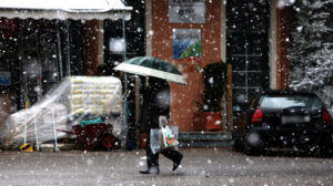
There is a significant change in weather from today, Saturday, with a slight drop in temperature across the country, strengthening winds and localized showers, while weak snowfall will occur in the mountains and in places in semi-mountainous areas of Central and Northern Greece, according to the EMY forecast and the analyses of meteorologists.
Drops of up to 8 degrees and strengthening winds
As EMY director Thodoris Kolydas points out, cold air masses from northeastern Europe will affect the country from today, Saturday, January 17, with the change becoming more noticeable on Sunday and Monday. The temperature will drop 7 to 8 degrees Celsius overall compared to today’s values.
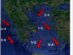
At the same time, northeasterly winds of 7 to 8 Beaufort will prevail in the Aegean Sea and easterly winds in the Ionian Sea up to 6-7 Beaufort, creating conditions of intense cold, especially in the east and north.
Where there will be rain and light snowfall
During the Saturday-Sunday weekend, local rain is forecast mainly in the eastern and southern mainland, as well as in Crete. Snowfall will be generally light and will affect:
– Mountainous parts of the whole country
– Mountainous areas of Central Sterea and further north.
– Parts of Thessaly, Macedonia, and Thrace, even at relatively low altitudes
According to meteorologist Yannis Kallianos, the phenomena do not have the potential for dense or generalized snowfall. “The weak character of snowfall will be the norm,” he notes, with snowfall or temporary moderate phenomena only in more favorable areas and higher altitudes.
Snowfall altitudes by day
According to the Kallianos analysis, the indicative snowfall start altitudes are as follows:
Saturday: 200-300 m in parts of Central Macedonia, 600-700 m in Western Macedonia, 800-1000 m in Attica, Evia, and Eastern Sterea
Sunday: lower altitudes, with 150-200 m. in Central Macedonia, 400-600 m. in Thessaly, Sterea, and Attica
Monday: even lower locally, with 0-100 m. in the northeastern Aegean and 250-350 m. in Thessaly
It should be clarified that the altitudes refer to the onset of snowfall and not necessarily the formation of snow cover, which depends on the duration, intensity, and ground temperature.
The possibility of a change from Tuesday remains open
Yannis Kallianos points out that from Tuesday, January 20, there is a possibility of a system approaching from the southwest with increased humidity. If combined with trapping of cold air masses near the ground, more significant snowfall may occur, even at low altitudes from Thessaly and further north.
This scenario remains under evaluation and will become clearer in the coming days, with meteorologists recommending monitoring the updated forecasts.
The forecast map shows the geographic distribution of the estimated cumulative snow depth in the country by Sunday night, Jan. 18.
Today’s weather
Light snowfall will occur at the beginning of the day in parts of Thrace, which will gradually stop. Rains will occur in the southern Ionian Islands, Crete, and in places in the Cyclades, while snow will fall in the mountainous parts of Crete. In the rest of the country, clouds are expected, with local rain or sleet in Macedonia and passing showers in Thessaly, Central and Eastern Sterea, Euboea and Eastern Peloponnese. Light snowfall will occur in the mountainous areas of the above regions, in semi-mountainous parts of Thessaly and Macedonia, but also in areas of Macedonia with lower altitude.
The temperature will range in Western Macedonia from -4 to 5 degrees, in the rest of Macedonia from -2 to 8 degrees, in Thrace from -5 to 6 degrees, in Epirus from 0 to 12 degrees, in the central continent from 0 to 8-10 degrees, in the western and southern continent from 5 to 12-14 degrees, in the rest of the eastern continent from 2 to 10-11 degrees Celsius, in the Ionian Islands from 6 to 12-14 degrees Celsius, in the islands of the North and Northeast Aegean from 3 to 8-9 degrees Celsius and in the rest of the Aegean islands and in Crete from 7 to 12-14 degrees Celsius. It should be noted that the minimum temperatures will occur in the evening.
In the Aegean Sea, northeast winds will blow with 4-5 Beaufort, but will gradually increase to 6-7 Beaufort. In the Ionian Sea, easterly winds will blow with intensities up to 5 Beaufort, and locally in the southern seas at the exit of the Corinthian Sea, 6 Beaufort.
In the prefecture of Attica and the city of Athens, we expect periodically increasing clouds with a possibility of light rain, mainly in the north of the prefecture. Light snowfall will occur at times in Parnitha and Kithairon. Winds will be northeast with 4-5 Beaufort and progressively locally 6 Beaufort. The temperature will range from 5 to 11 degrees. It should be noted that the minimum temperature will be reached in the evening.
In Thessaloniki, we expect clouds with occasional light rain in the lowlands and occasional light snowfall in the mountains. Winds will be easterly with intensities of 3-4 Beaufort. The temperature will range from 3 to 7-8 degrees. It should be noted that the minimum temperature will be reached in the evening.
The weather on Sunday, January 18
In western and central Macedonia, Thessaly, the northern Aegean islands, Evia, eastern Sterea, and eastern Peloponnese, increasing clouds with local rain or sleet and light snowfall in the mountains, in western and central Macedonia and Thessaly, and in semi-mountainous areas. In the rest of the country a few clouds, partly cloudy with some local rain in the Cyclades, Crete, and in the Dodecanese, and light snowfall in the mountains of Crete.
Winds will blow in the west from east 4 to 6 Beaufort, in the east from north 5 to 7, and in the southern Aegean Sea locally 8 Beaufort.
The temperature will drop slightly, mainly in terms of maximum values. In the northern mainland, it will not exceed 04 to 06 degrees Celsius, in the rest of the mainland and the Ionian Islands, 7 to 12 degrees, and locally in the western mainland and the Cyclades, 13 to 14 degrees Celsius, and only in southern Crete and the Dodecanese will reach 15 to 16 degrees Celsius. Frost will occur in the morning and evening hours in the continental areas, and in the northeast, it will be strong in places.
The weather on Monday, 19 January
In western and central Macedonia, Thessaly, the northern Aegean islands, Evia, eastern Sterea, and eastern Peloponnese, increasing clouds with local rain or sleet and snowfall in the mountains, as well as in semi-mountainous areas of western and central Macedonia, Thessaly, and central Sterea. In the rest of the country, a few clouds, partly cloudy with some local rain in the Cyclades, Crete, and the Dodecanese, and light snowfall in the mountains of Crete.
Winds will blow in the west from east directions and in the east from north 5 to 7 and in the Aegean Sea locally 8 Beaufort with a tendency to increase during the night.
The temperature will not change significantly. Frost will occur in the morning and evening hours in the continental areas, and in the north,h it will be strong in places.
Ask me anything
Explore related questions


