





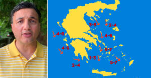
Temperatures are set to ease today as the meltemi winds strengthen over the Aegean Sea, significantly raising the risk of wildfires breaking out and spreading, according to protothema.gr meteorologist Giorgos Tsatrafyllias. Some limited instability is also expected, mainly over mountainous inland areas. There are currently no signs of an approaching heatwave.
Today, Monday, July 13, skies will be generally clear across the country. From midday onward, clouds will build over the mainland, bringing isolated local rain or showers, mainly in mountainous regions.
Highs will reach 35 to 36 degrees on the mainland, 36 degrees in the Dodecanese, and locally 37 degrees in Crete. Winds will blow from the north and northwest, reaching 6 Beaufort in the Ionian Sea and locally 7 Beaufort in the central and southeastern Aegean.
In Attica, isolated local showers are forecast from midday onward. Winds will blow from the north at up to 5 Beaufort, with temperatures ranging from 23 to 35 degrees.
In Thessaloniki, scattered clouds are expected around midday and in the afternoon. The wind will reach 6 Beaufort in the Thermaic Gulf, with temperatures climbing to 33 degrees.
Similar conditions will persist on Tuesday, before temperatures rise again on Wednesday and Thursday, with highs locally reaching 38 to 39 degrees in the Thessalian Plain, the Argolic Plain and the Kopaida Plain.
From Friday and through the weekend, temperatures will drop again to highs of 36 to 37 degrees. Unsettled conditions will continue on the mainland, while the meltemi winds in the Aegean will blow at 6 to 7 Beaufort.
Ask me anything
Explore related questions




