The heatwave intensifies today, Tuesday (July 9, 2025), with Greece facing dangerously high temperatures before a rapid drop of up to 10°C starting tomorrow. According to the latest emergency weather bulletin from the National Meteorological Service (EMY), extreme heat and strong winds will dominate the forecast before a cold front moves in.
Temperature Extremes Across the Country
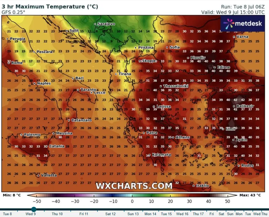
Eastern mainland: 38°C to 40°C expected, with localized peaks of 41°C in eastern Sterea and the eastern Peloponnese.
Aegean Islands, Dodecanese, and Crete: 37°C to 38°C, locally reaching 39°C.
Powerful Winds Signal Incoming Weather Shift
Winds will strengthen significantly throughout the day:
From midday, strong westerlies in central and southern Greece.
By afternoon, northwesterly winds in the Ionian Sea and western mainland.
From early evening, very strong northerlies in western and central Macedonia, Thessaly, and the Sporades.
Overnight into Thursday, gale-force northeast winds will sweep across eastern Macedonia, Thrace, and the northeastern Aegean.
End of Heatwave: Cold Front Brings Relief
Meteorologist Theodoros Kolydas confirms that the intense heat is expected to subside starting tomorrow.
“The latest analysis of the 850 hPa temperature map shows extreme warmth over Greece, in sharp contrast to much cooler air over the northwest Balkans. As the cold front pushes through, wind directions will shift from west-northwest to north-northwest, driving a sharp temperature drop and strong winds,” Kolydas explained.
He adds:
“While westerly winds will keep parts of eastern Greece hot today, tomorrow will bring a notably different, cooler weather pattern.”
National Weather Overview
Today:
Mostly clear skies across most of the country.
Some local cloud cover in the northwest with a chance of isolated showers.
Afternoon clouds may develop over northern Greece, possibly leading to brief storms in Macedonia and Thrace.
Winds:
West to northwest winds at 3–5 Beaufort.
Central and southern regions may see gusts up to 6 Beaufort.
By afternoon and evening, northerly winds will reach 6–7 Beaufort in many areas.
Temperatures:
Eastern mainland: 38°C–41°C
Other mainland regions: 35°C–37°C
East Aegean, Dodecanese, Crete: 37°C–39°C
Other islands: 33°C–36°C
Regional Highlights
Macedonia & Thrace: Clear with some afternoon clouds and possible rain. Winds shift from west to north in the evening (up to 7 Beaufort). Temperatures range from 22°C to 39°C.
Ionian, Epirus, West Mainland, West Peloponnese: Sunny, with 34°C–36°C highs inland. Westerly winds strengthen to 7 Beaufort.
East Sterea, Evia, East Peloponnese: Hottest region, with highs of 41°C. Winds west-northwest up to 7 Beaufort.
Cyclades & Crete: Sunny, breezy, and hot—temperatures up to 39°C in Crete.
Eastern Aegean & Dodecanese: Warm and dry, with moderate winds. Temperatures up to 38°C.
Thessaly & Sporades: Clear skies. Temperatures up to 40°C inland, 36°C in the islands.
Attica (Athens): Sunny with highs of 39°C, slightly lower along the coast.
Thessaloniki: Sunny with possible afternoon clouds and rain. Highs around 38°C.
Wednesday (July 10) Forecast
Eastern Macedonia & Thrace: Possible light rain in the morning; otherwise clear.
Rest of Greece: Mostly sunny, with some afternoon clouds over the mountains.
Winds: Northerly, 4–7 Beaufort. Strong gusts early in the northeast.
Temperatures: Sharp drop across most regions. Highs of 31°C–33°C on the mainland, 34°C–35°C in the east. Island temperatures 28°C–31°C.
Looking Ahead: Thursday to Sunday
Thursday (July 11):
Clear skies dominate. Local rain or isolated thunderstorms possible in northern mountains.
Northerly winds continue (up to 6 Beaufort).
Temperatures remain steady, slightly lower in the southeast.
Friday (July 12):
Mostly sunny with afternoon showers possible over the mountains.
No major temperature changes.
Saturday (July 13):
Clear with local clouds. Isolated mountain thunderstorms possible.
Winds north, 3–6 Beaufort.
Slight rise in temperatures on Sunday (July 14).
Critical Fire Risk Alert
🔥 Very High to Extreme Fire Danger Today The General Secretariat for Civil Protection has issued a Category 5 (Extreme) fire risk warning for:
Attica
Boeotia
Fthiotida
Magnesia
Corinthia
Other areas remain under Category 4 (Very High) risk, including parts of the Peloponnese, Thessaly, Macedonia, Thrace, and Crete.
Citizens are urged to exercise extreme caution and avoid any activities that could spark fires.
✅Από την ανάλυση του χάρτη των 850 hPa διακρίνουμε τις υψηλές θερμοκρασίες στην περιοχή μας, αλλά και το μεγάλο κοντράστ με αυτό των ΒΔ Βαλκάνίων, λόγω του ψυχρού μετώπου που θα διέλθει από την χώρα μας. Το ρεύμα αρχικά είναι Δ-ΒΔ που προς το βράδυ γίνεται Β-ΒΔ , οπότε αυτό… pic.twitter.com/3tzK4qgU6r