





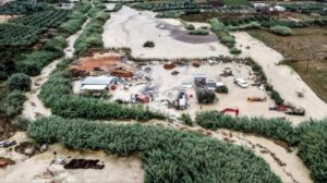
Storms that battered Crete overnight caused serious disruption, with the east of the island worst affected.
The heaviest rain fell in the early hours of Saturday around Ierapetra, in the Lasithi region, particularly in the villages of Ferma and Makry Gialos, where intense downpours led to flash flooding.
The Ierapetra rescued 23 people from homes and vehicles in a series of call-outs. Crews also took dozens of requests to pump water out of houses and businesses inundated by the volume of rain.
‼️🚨‼️Κακοκαιρία 🌧️ – Κρήτη: Νύχτα αγωνίας για τα έντονα φαινόμενα –
— Ε🇬🇷Λ🇬🇷Λ🇬🇷Α🇬🇷Σ (@GRHellasGR) October 2, 2026
🆘Μήνυμα 112: «Περιορίστε τις μετακινήσεις» έως το απόγευμα του Σαββάτου – Στο επίκεντρο ⚠️Ανώγεια, ⚠️Ζωνιανά και ⚠️Οροπέδιο ⚠️Λασιθίου.
Έχουν εκδοθεί προειδοποιήσεις από το 112 και απαγορεύσεις κυκλοφορίας… pic.twitter.com/9GUlBcuBZK
Flooding in Flamouriana
Floodwater also hit Flamouriana, in the municipality of Agios Nikolaos, sweeping large amounts of mud and debris onto roads. The deposits have slowed traffic and made some areas hard to reach.
Work crews are on site clearing the roads and removing the material so that traffic can gradually return to normal.
Conditions ease in Zoniana
The situation has improved in Zoniana and across the wider mountainous Mylopotamos area, in the Rethymno region, which suffered serious damage from the storms over the previous two days.
Although the rain has eased, emergency teams remain on alert. The situation is being closely monitored, and further problems cannot be ruled out if the heavy rain returns.
The latest flooding follows storms on Thursday that killed a livestock farmer in Rethymno and led to around 255 emergency calls across the Rethymno, Heraklion and Lasithi regions. The Region of Crete has kept its civil protection mechanism on its highest “Red Code” alert since Wednesday evening, and the status remains in force until Sunday.
Orange warning for the Dodecanese
The Hellenic National Meteorological Service (EMY) has updated its emergency bulletin on dangerous weather. Heavy rain and thunderstorms are expected in Crete throughout Saturday, easing gradually from late at night, and in the Dodecanese from midday on Saturday. An orange warning is in force for the Dodecanese, mainly the southern islands, from Saturday midday until midday on Sunday.
Over the Aegean, north-easterly gales of force 8 to 9 on the Beaufort scale are forecast locally until Saturday afternoon.
Meteo, the weather unit of the National Observatory of Athens, is warning of a fresh round of intense rainfall in Crete, with particularly high totals expected in the mountainous and semi-mountainous areas. Rain that began on Friday afternoon will intensify into thunderstorms and stay heavy in the mountains, foothills and northern parts of the island until Saturday evening. On Sunday, rain and local storms are expected on and off until midday, before easing.
Meteo’s forecast model suggests especially large accumulations over the Cretan uplands by Sunday evening. Under its rainfall episode classification, Saturday’s weather is rated Category 4, described as “very significant”.
Elsewhere in the country, cloud will increase in the east and south, with local rain on Friday in eastern mainland Greece, Evia and the Cyclades. From Saturday afternoon until Sunday morning, local storms are forecast in the Dodecanese, particularly on Rhodes.
Strong northerly winds over the eastern mainland and the Aegean will persist until Saturday, easing slightly on Sunday.
The weather today
Saturday will be sunny with a little cloud, with more cloud in the east and south and local rain in Evia, eastern mainland Greece and the Cyclades. Local storms will hit Crete and the Dodecanese, turning heavy in the north, mountains and foothills of Crete until the evening, and in Rhodes after the afternoon.
Temperatures will range from 10C to 24C in northern Greece (4C to 20C in western Macedonia), 15C to 23C in central and southern Greece, 12C to 25C in western Greece, 17C to 21C in the Cyclades and Crete, 16C to 22C on the eastern Aegean islands and 18C to 23C in the Dodecanese.
Northerly winds in the Aegean will be strong to near gale force 6 to 7, reaching gale force 8 locally in the central and southern Aegean, with gusts of up to 90 km/h, easing slightly later. In the Ionian, winds will be easterly and light to moderate, force 3 to 4, turning north-westerly at the same strength in the central and northern Ionian after midday.
In Attica, cloud will increase at times in the north and east, with a chance of light rain in the morning in the north and over high ground. Temperatures will range from 15C to 21C, with the north 3C to 4C cooler. Northerly winds will blow at force 6, reaching near gale force 7 in the east with gusts of 80 to 90 km/h, easing slightly after the afternoon.
Thessaloniki will be sunny, with temperatures between 14C and 24C. Winds in the Thermaic Gulf will be north-westerly, light to moderate at force 3 to 4.
Ask me anything
Explore related questions




