






Greece is bracing for severe weather today, Tuesday 13 October, with heavy rainfall, thunderstorms, possible hail and gale-force winds among the main hazards.
The Hellenic National Meteorological Service (EMY) has updated its emergency severe weather bulletin, warning that the conditions will continue into Wednesday (14 October). Particular concern centres on Magnesia, the Sporades islands and Evia, where heavy and prolonged rainfall is forecast. In Attica, the strongest thunderstorms are expected from late afternoon, while north-easterly winds in the Aegean could briefly reach force 10 on the Beaufort scale.
According to meteorologist Giorgos Tsatrafyllias, some areas could receive rainfall in just 48 hours equivalent to, or exceeding, the average total for the whole of October. Meanwhile, Meteo, operated by the National Observatory of Athens, has classified the rainfall event as Category 3 (Significant), forecasting falling temperatures and strengthening winds over the seas.
Where and when the worst weather is expected today
The storm system will move in from western Greece before gradually shifting eastwards. The EMY forecast identifies the periods when the most intense conditions are expected.
From the morning until late afternoon, heavy rain and thunderstorms will affect Lefkada, Kefalonia and Zakynthos, western Central Greece, and western and southern Peloponnese. By midday, severe weather will also reach Halkidiki, where it is expected to continue until Wednesday morning.
From the afternoon, the worst of the weather will move towards the Sporades, eastern Thessaly, particularly Magnesia, and Evia. The HNMS has issued a specific warning for these areas, where thunderstorms are expected to be both intense and prolonged.
Brief but intense weather conditions are forecast from late afternoon until late at night in north-eastern Peloponnese, eastern Central Greece, including Attica, and the Cyclades, particularly their western and northern parts.
Crete will also be affected from the evening, mainly in Chania and Rethymno, while severe thunderstorms are expected to reach the Dodecanese late at night. Coastal and seaside areas face an increased risk of localised hail
Elsewhere in the country, rain and scattered thunderstorms are expected, generally of lower intensity and shorter duration, according to Meteo.
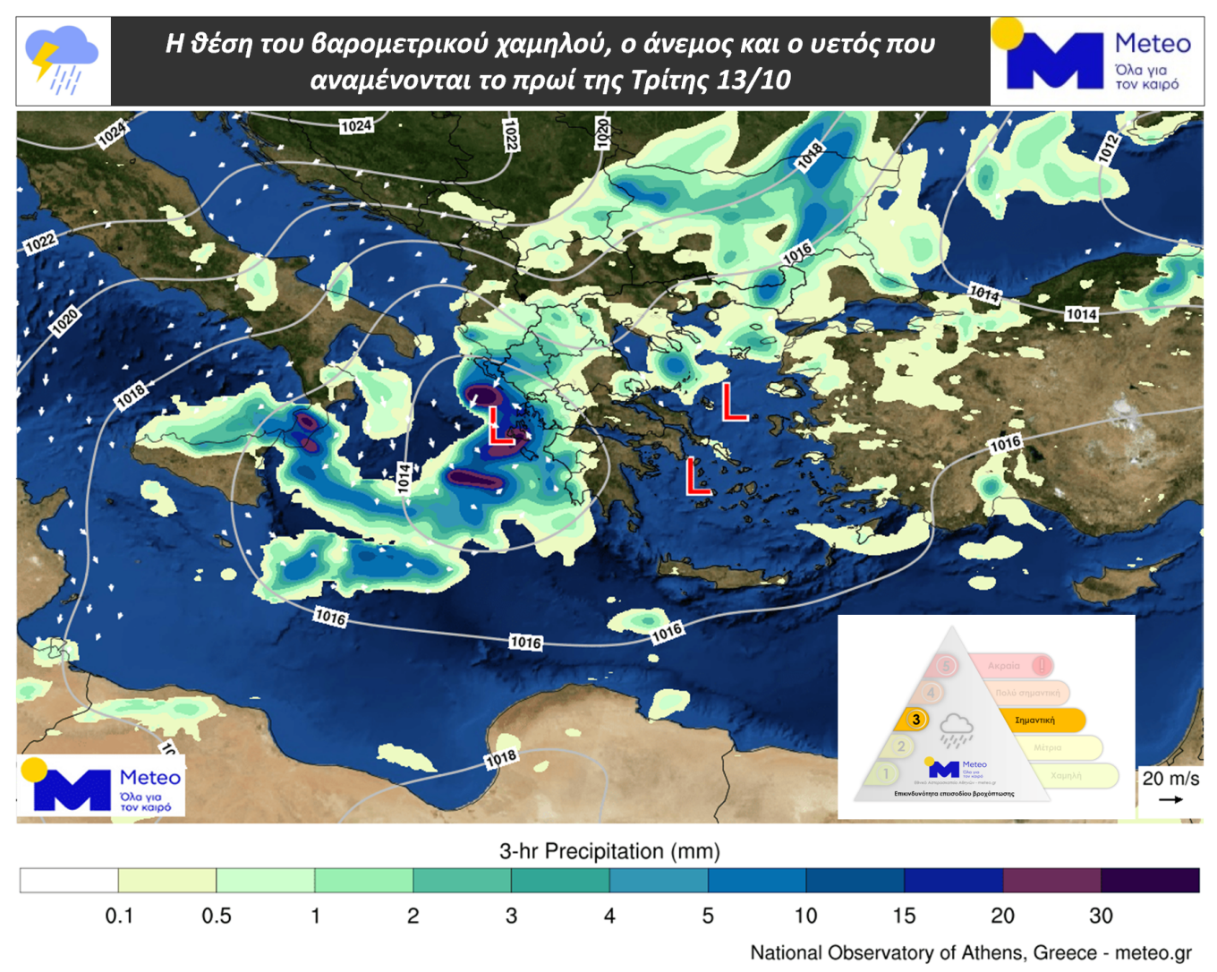
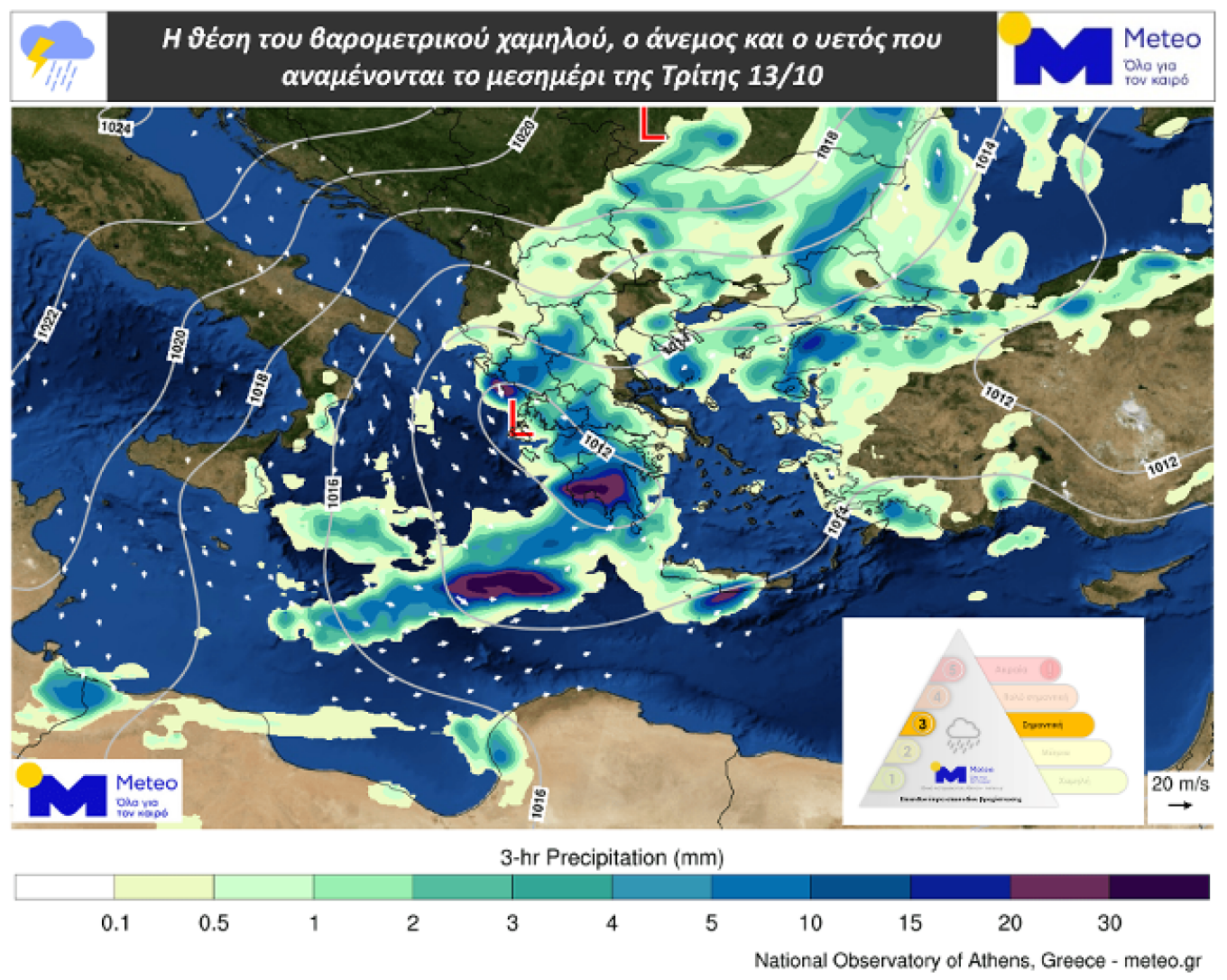
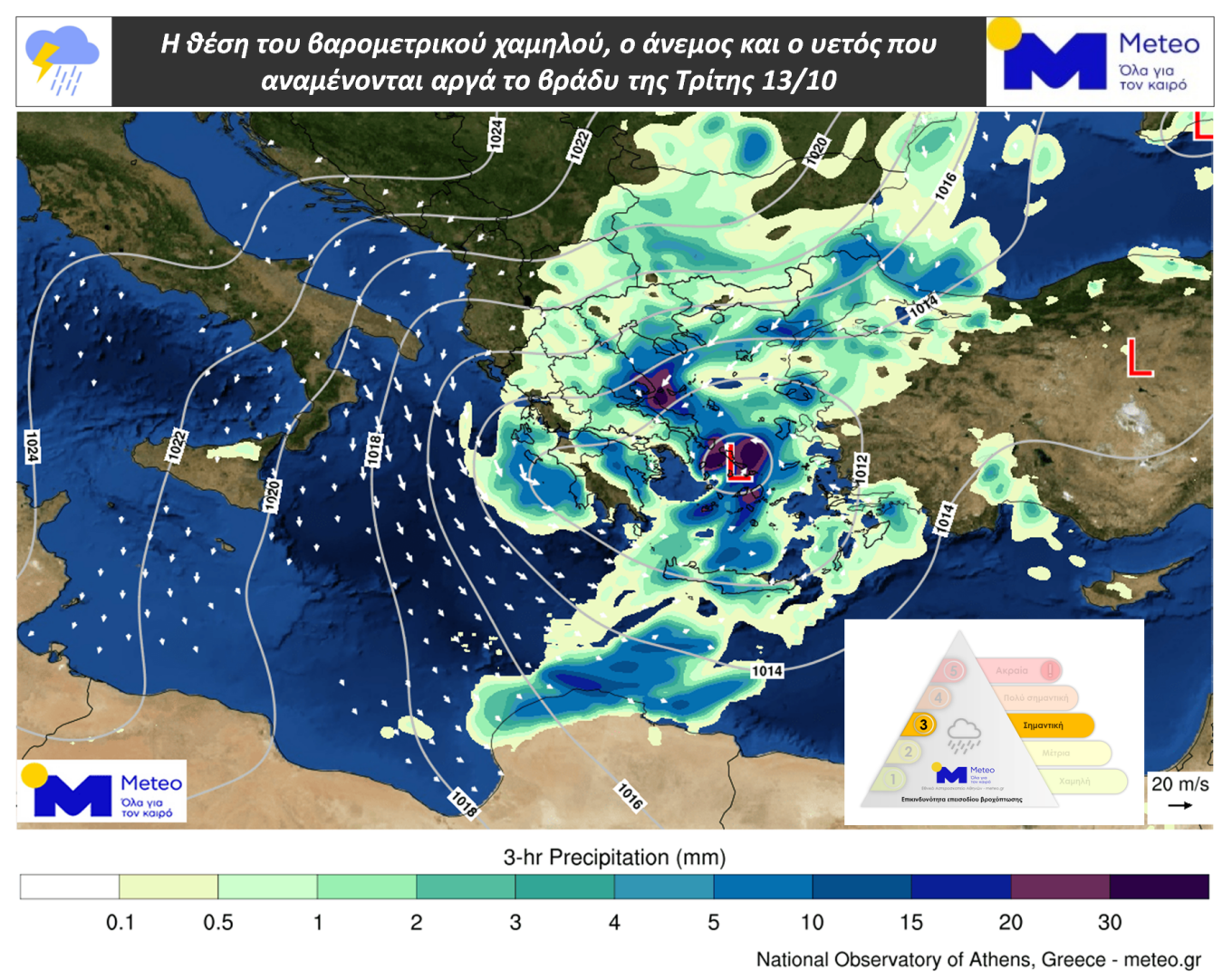
Tsatrafyllias warns of up to 150mm of rain in Magnesia, the Sporades and Evia
The risk of flooding is particularly high in parts of eastern Thessaly and the Sporades, as well as northern and central Evia, where rainfall is expected to persist for an extended period.
According to Giorgos Tsatrafyllias, total rainfall over 48 hours could locally exceed 100mm, while some forecast scenarios suggest totals of between 130mm and 150mm.
These figures become more significant when compared with typical October rainfall. Volos, for example, receives an average of about 65mm of rain over the entire month, while Skiathos records 75mm and Chalkida 60mm.
This means that, if the more severe forecasts prove accurate, some areas could receive more than a month’s worth of rain in just two days.
The meteorologist cautions, however, that flood risk does not depend solely on the total amount of rainfall. The intensity and duration of the downpours, ground conditions and the ability of drainage infrastructure to carry away large volumes of water all play a crucial role.
In Pelion, the Sporades and Evia in particular, persistent thunderstorms could increase the risk of overflowing streams, localised flooding and landslides.
Attica: When will thunderstorms arrive, and how much rain is expected?
The weather in Attica will gradually deteriorate on Tuesday, with cloud cover and rain developing after midday. According to the HNMS’s updated warning, temporarily severe thunderstorms are expected from late afternoon until late at night.
Giorgos Tsatrafyllias estimates that total rainfall in Attica could range from 20mm to 50mm in some areas. Where more intense thunderstorms develop, totals could reach 60mm to 80mm.
For comparison, Athens receives an average of about 50mm of rain throughout October. The higher totals indicated by some forecast scenarios could therefore cause problems on roads and in areas with inadequate drainage.
According to Meteo’s daily forecast, temperatures in Attica will range from 18C to 22C. Winds will initially be variable at force 2 to 4, turning northerly after midday and strengthening to force 3 to 5 from the afternoon.
Wednesday: Thunderstorms persist in the most vulnerable areas
Wednesday (14 October) is also expected to bring difficult conditions, particularly in areas that will already have received large amounts of rain the previous day.
In Halkidiki, severe weather is forecast to continue until the morning. In Magnesia, the Sporades and Evia, however, thunderstorms are expected to persist until the afternoon, increasing the risk of waterlogging and placing additional pressure on drainage networks.
Heavy rain in the Dodecanese is expected to continue until the afternoon, while conditions in western Crete, particularly Chania and Rethymno, could remain unsettled until late at night.
Meteo forecasts that conditions will gradually ease across much of the country from Wednesday afternoon, although this does not mean the rain will stop everywhere at the same time.
Aegean winds could reach force 10, with ferry disruption possible
In addition to heavy rainfall, strengthening winds will be a major feature of the storm system, particularly in the Aegean.
According to the HNMS’s updated emergency bulletin, north-easterly winds of force 8 to 9 are expected from Tuesday evening, briefly reaching force 10 in some areas. The strongest winds will initially affect the northern Aegean before spreading to the central Aegean. Very strong gale-force winds are forecast to persist until late on Wednesday night.
In the Ionian Sea, Meteo forecasts that winds will gradually turn north-westerly, reaching force 5 to 7 and briefly force 8. In the southern Aegean, westerly to south-westerly winds of force 3 to 5 are expected, strengthening to force 4 to 6 from the afternoon.
These conditions could disrupt ferry services, potentially causing delays, timetable changes or sailing bans. Air travel could also be affected, particularly at island airports exposed to strong crosswinds.
Temperatures to fall as forecast issued for the rest of Greece
The arrival of the low-pressure system will bring a gradual drop in temperatures. Maximum temperatures are generally expected to remain between 22C and 23C on the mainland and between 25C and 27C on the islands.
According to Meteo, temperatures in western Macedonia will range from 7C to 12C, while the rest of Macedonia and Thrace will see temperatures of 11C to 19C. Thessaly is forecast to range from 13C to 20C, and Epirus from 10C to 18C.
In Central Greece and the Peloponnese, temperatures of 11C to 22C are expected. The Ionian islands will see temperatures of 14C to 18C, while the northern and eastern Aegean will range from 14C to 22C. Temperatures in the Cyclades and Dodecanese are expected to range from 14C to 25C, and in Crete from 17C to 27C.
In Thessaloniki, cloudy skies and occasional localised rain are forecast. Winds will be north-westerly at force 2 to 4, while temperatures in the city centre will range from 16C to 23C.
Temperatures are expected to fall further on Wednesday, with maximums generally reaching 20C to 22C.
Civil Protection on heightened alert as authorities issue safety advice
In view of the dangerous weather, the General Secretariat for Civil Protection has placed the relevant state services, regional authorities and municipalities on heightened alert to ensure that any problems can be dealt with promptly. The Fire Service has also activated its operational plan for responding to flooding.
Particular caution is advised in areas with a history of flooding, near streams and torrents, and at low-lying points on the road network where large volumes of water can accumulate.
People are urged to avoid crossing streams and torrents, even when heavy rain is not falling at that moment, as water levels can rise suddenly. They are also advised to avoid unnecessary travel during thunderstorms, secure objects that could be blown away and stay away from trees, poles and structures that could be damaged.
Drivers should take particular care because of reduced visibility, possible water accumulation on roads and strong gusts of wind. Extra caution is also needed in underground spaces that are vulnerable to flooding.
When will the severe weather ease?
Conditions are expected to improve more noticeably from Thursday, 15 October, with the weather forecast to settle across most parts of the country.
The last of the rainfall may persist mainly over the eastern and southern Aegean and parts of Crete. Strong northerly winds could continue in the Aegean even after the thunderstorms begin to weaken.
The EMY has announced that the updated emergency severe weather bulletin will be reviewed in 12 hours, based on the latest forecast data.
Ask me anything
Explore related questions




