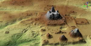
In a new study published in the journal Ancient Mesoamerica, researchers from Texas-based universities used LiDAR, or laser-based imaging, to open up more of Maya settlement history than ever known before.
The light detection and ranging technology pierced through the heavily forested Mirador-Calakmul Karst Basin in northern Guatemala to show that more than 1,000 settlements covered about 650 square miles, all connected with 110 miles of causeways that the Maya people used to travel their settlements, cities, and cultural centers. The researchers even located canals and reservoirs, highlighting the expanse of the organization from the Maya culture in the middle and late preclassic period from about 1000 BC to 150 AD.
It all amounted to a first look at “an area that was integrated politically and economically, and never seen before in other places in the Western Hemisphere,” study co-author Carlos Morales-Aguilar, of the Department of Geography and the Environment at the University of Texas at Austin, tells Live Science. “We can now see the entire landscape of the Maya region.”
Read more: Popular Mechanics
Ask me anything
Explore related questions


