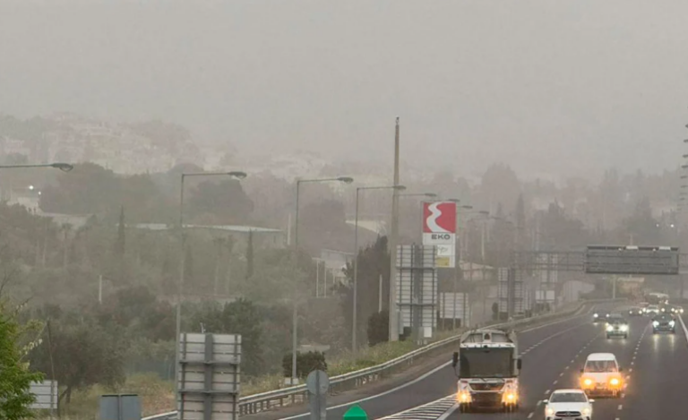
High concentrations of African dust have affected Greece where gradually the quality of the atmospheric air will begin to improve tomorrow. Notably, a significant reduction in dust concentrations is expected from midday onwards heading to the eastern parts while still being visible during the morning hours.
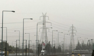
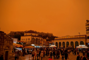
Yesterday, increased concentrations of dust in the atmosphere created an orange veil covering Greece creating a ghastly scene with images captured by meteorologist Kostas Lagouvardos. Noted, was an increase in hospital admissions with respiratory problems where in a statement released by the Association of Pulmonologists advised was caution and restriction of movement for vulnerable groups.
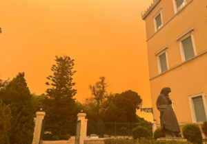


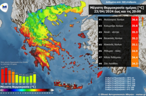
Dust concentrations also affected the region of Ilia as well where images taken at the port of Katakolon, the beach of Karouta, and the area of Zacharo show an orange veil covering the areas. Chania was also impacted by the African dust creating a suffocating atmosphere. Today’s temperature in the Cretan city is said to reach a high of 35 degrees Celsius. According to the director of the Hellenic National Meteorological Service (EMY), Thodoris Kolydas, the African dust will begin to recede as of Wednesday morning.
Here’s when people think old age begins & why experts think it’s starting later
The onslaught of African dust as captured by satellite
New satellite images depict the extent of the phenomenon of African dust that has engulfed all of Greece. Data from the American Aqua satellite of NASA on Tuesday showed a high resolution of an intense wave of African dust, known as “Minerva red,” in the Eastern Mediterranean region significantly affecting Greece. From the region of Syrtis moving towards Greece large waves of African dust affected air quality. In addition to the African dust, high temperatures were recorded in areas of Southern Greece, mainly in Crete, reaching a record high of 36.6°C in Falassarna, Chania,
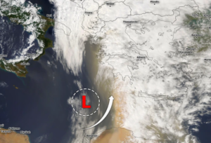
Minerva Red African dust wave has not only affected Greece yesterday, air traffic was suspended in eastern Libya due to a powerful sandstorm coming in from the Sahara leading to temporary closure of public services and educational institutions, according to local authorities.
Issues arose at all airports in the region, mainly in Benghazi, where the runway was covered by a thick layer of sand.
Today’s weather
Initially, improved weather is expected throughout the country. Concentrations of Saharan dust in the atmosphere will be elevated, but gradually will move eastward and be limited to the Aegean Sea. Rain showers will occur in the Ionian Islands and Epirus in the evening hours, phenomena that will extend to areas of Macedonia, Western Thessaly, Western Sterea, and Northwestern Peloponnese overnight towards Thursday.
Temperatures will range from 4 to 21 degrees Celsius in Western Macedonia, from 8 to 25 degrees Celsius in the rest of northern Greece, from 8 to 23 degrees Celsius in Epirus, from 8 to 26 degrees Celsius in Thessaly, from 12 to 25-27 degrees Celsius in other mainland regions, from 13 to 24 degrees Celsius in the Ionian Islands, from 15 to 25 degrees Celsius in the island regions of the Northern, Central, and Eastern Aegean, and from 18 to 26 degrees Celsius in Crete and the Dodecanese islands.
Winds in the Aegean Sea will becoming in from the west with intensities of 4-5 Beaufort locally reaching 6 Beaufort. In the Ionian Sea, northwesterly winds of 4-5 Beaufort will prevail but gradually in the Northern Ionian will turn to southwestern winds with same intensities. Western winds will intensify reaching up to 6 Beaufort in the Corinthian Gulf.

Forecast for Thursday, 25-04-2024:
Initially, in the Ionian, Epirus, Macedonia, and gradually in the rest of the western and northern parts of the country, there will be cloudiness with local showers and sporadic thunderstorms. Snowfall is expected in the western and northern mountainous areas (above 1500 meters altitude). From afternoon hours, the phenomena will weaken, and the weather will improve. In the rest of the country, there will be occasional cloudiness with local showers mainly in Thessaly and other mainland mountainous areas. Visibility in the morning and evening hours will be locally limited, mainly in the east. Winds will be coming in from the west at 3 to 5 Beaufort and locally up to 6 Beaufort. In the east, southerly winds will prevail, gradually turning to the west at 4 to 5 Beaufort and locally up to 6 Beaufort in the south. Temperatures will decrease to 16 to 18 degrees Celsius in the northwest, 19 to 22 degrees Celsius in the rest of the mainland and island regions.
Forecast for Friday, 26-04-2024:
Generally the weather will be sunny. In the afternoon and evening hours in the mainland there will be clouds with local showers or thunderstorms in the western and northern mainly mountainous areas. Visibility in the morning and evening hours will be locally limited, mainly in the west, with winds coming in from the west at 3 to 4 Beaufort. In the east, winds will blow from northerly directions at 3 to 5 Beaufort, and in the southeastern Aegean up to 6 Beaufort. Temperatures will show a slight increase, mainly in the west and north.
Forecast for Saturday, 27-04-2024:
Sparse cloudiness, locally denser at times, with the possibility of local showers or downpours in the west and north. Winds will blow from northerly directions at 3 to 5 Beaufort, and in the Aegean locally at 6 to 7 Beaufort, strengthening to 7 Beaufort in the evening. Temperature will not show a significant change.
Forecast for Sunday (Palm Sunday), 28-04-2024:
Generally the weather will be sunny, but gradually in the northeast and later in the rest of the eastern mainland, the Cyclades, and Crete there will be clouds where in the northeast, local showers are expected. Winds will blow from northerly directions at 3 to 5 Beaufort, and in the Aegean, at 6 to 7 Beaufort. Temperature will show a slight further increase, mainly in the west and south.
Ask me anything
Explore related questions


