Hopes at Amphipolis are now pinned on what geologists will find as they geoscan the hill covering the ancient underground tomb or tombs. The Department of Geophysics of the University of Thessaloniki will perform an electrical tomography on Kasta Hill where the tomb is located. The ground is to be covered with cables and an algorithm created by scientsts of the lab under the direction of Grigoris Tsokas, Professor of Applied Geophysics.
Previous geologists who had scanned the tomb in 1999 (L. Polymenakos et al) found at least two very promising sites for tombs located in the south and southwest of the hill with high density areas and possible structures that could be stone jars. Since that time methods and sensors have improved and geologists will be able to produce better resolutions.
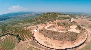
Discussions are currently taking place concerning how the geological investigation will take place and there are fears that certain areas of the hill are unsteady and a cavein could be disastrous. Huge amounts of soil have been subtracted from the Tumulus Hill and that, accompanied by erosion, could (a) bring about a better result, but (b) increase danger of the structure caving in.
Dr. Orit Peleg Barkat of the Hebrew University of Jerusalem fears that there are already signs of unsteadiness. She states that a great deal of the interest in the case of the tomb isn’t just in the archaeological finds but in the occupant of the huge monument and there are hopes of finding that person’s remains.
Ask me anything
Explore related questions


