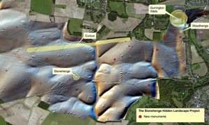
After spending four years scanning the ground surrounding the world’s most famous prehistoric monument, University of Birmingham archeologists have produced a map of unprecedented detail of the earth beneath Stonehenge.
The findings have yielded many unexpected surprises that are transforming our understanding of this ancient landscape, including details of a nearby 1.5 kilometer-round “super henge” and a plethora of previously unknown monuments.
The Guardian reports:
Researchers uncovered 17 new chapels and hundreds of archaeological features around the neolithic standing stones on Salisbury Plain, Wiltshire, including forms of monuments that have never been seen before.
Brought together for the first time in a digital map of the historic site, the discoveries transform how archaeologists view a landscape that was reshaped by generations for hundreds of years after the first stones were erected around 3100BC.
(“This radically changes our view of Stonehenge,” said Vince Gaffney, head of the Stonehenge Hidden Landscapes Project at Birmingham University. “In the past we had this idea that Stonehenge was standing in splendid isolation, but it wasn’t … it’s absolutely huge.”)
He added that around Stonehenge people created “their own shrines and temples. We can see the whole landscape is being used in very complex ways”.
The finds follow the discovery, that the monument was originally circular. Researchers said that an insufficiently long hosepipe might have helped them solve one of the enduring mysteries of Stonehenge: whether the monument was originally built as a full circle or a C-shape.
Ask me anything
Explore related questions


