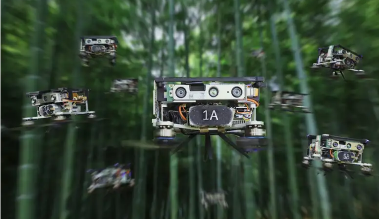
A new navigation system enables a swarm of 10 lightweight drones to fly together without crashing into one another or obstacles, even in challenging places such as forests.
Drones can compute their location and find a path to follow using a panoply of sensors, which can be expensive and unwieldy. Shrinking down a drone often involves getting rid of key components, impacting its ability to travel safely.
Xin Zhou at Zhejiang University in China and his colleagues have developed a new method that reduces the size and hardware requirements of a drone while keeping its computing nous.
The palm-sized, 300-gram drone uses off-the-shelf computer components powered by a 100-gram battery that can keep it aloft for up to 11 minutes. The drone has a camera that feeds real-time footage to its processing unit.
The NATO Tiger Meet 2022 Exercise has begun (video-photos)
A localisation algorithm creates a 3D image of the scene and regularly sets the drone targets to reach within that scene. It looks out for obstacles – and other drones – and readjusts the flight pattern in real time. It then plans the most computationally efficient route through the area.
This algorithm accounts for the largest share of the drone’s processing power, but it doesn’t require the specialist processors that other drone navigation systems do. Perhaps most importantly, the algorithm doesn’t require GPS signals to locate itself, meaning it can be used in a broader range of places where such signals are low.
“To achieve a quality map, built from a distributed collection of robots, of the detail demonstrated is an excellent piece of engineering,” says Jonathan Aitken at the University of Sheffield, UK. “To couple this with the additional successful navigation and avoidance of obstacles, and critically other members of the swarm, is an excellent achievement.”
Source: New Scientist
Ask me anything
Explore related questions


