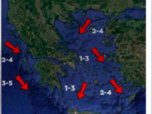
The weather pattern is changing with showers and thunderstorms in the coming hours in the north-east, while a south-westerly wind will blow African dust away, resulting in the heat being restricted to the south.
However, the instability will be exacerbated next weekend (25-26.05.24), with the onset of the “cold lake”
What is a cold lake:
The director of the National Weather Service, Thodoris Kolydas, referring to the instability of the weather, explains the phenomenon of the “cold lake”, in a post on X.
“This weather is due to a detached low accompanied by a cold mass in the upper atmosphere. The air masses in the low will contrast with the warmer and wetter air masses in the lower layers. This contrast, and the dynamics of the low, will cause vertical clouds (Cu, CB) and thunderstorms will occur, especially during the warm daytime hours on the continents.”
The “Cold Lake” is an extended area of low pressure with low temperatures. Unless atmospheric circulation changes significantly, it could remain stationary in an area for several days. This results in a divergence of temperatures from seasonally normal levels in the lower layers of the atmosphere.
A cold lake is a barometric low, i.e. a severe weather event over the Greek area, which swirls around itself very slowly, and is accompanied by very low temperatures. In the upper layers of the atmosphere, temperatures can reach -20 degrees Celsius. The temperature difference from the upper layers to the lower layers dynamizes the atmosphere and therefore we have these extreme storms and strong hailstorms that we are concerned about.
The weather today:
Clouds are expected in the eastern and northern Aegean, the northern mainland and the eastern parts of Thessaly where local showers and occasional thunderstorms will occur from the early morning hours. In the rest of the country, generally clear weather is expected with only local clouds in the afternoon and afternoon. Dust concentrations in the atmosphere will be relatively high in the eastern parts of the Aegean and Thrace.
The temperature in Western Macedonia will range from 13 to 25 degrees Celsius, in the rest of Macedonia and Thrace from 14 to 29, in Epirus from 12 to 26, in Thessaly from 16 to 31, in Sterea and Peloponnese from 16 to 31, in the Ionian islands from 13 to 25, in the North and East Aegean islands from 14 to 27, in the Cyclades from 16 to 27, in the Dodecanese from 18 to 25 and in Crete from 18 to 30 degrees Celsius.
Winds in the Central and North Aegean will blow from the west from 3 to 5 Beaufort but from the afternoon they will shift to north from 2 to 4 Beaufort. In the Central Aegean, winds will blow from the northwest at 3 to 5 Beaufort from the northwest. In the South Aegean, winds will blow from westerly directions 4 to 6 Beaufort. In the Ionian Sea the winds will blow from the northwest at 3 to 5 Beaufort.
FORECAST FOR FRIDAY 24-05-2024
Generally clear weather with occasional clouds in the midday and afternoon hours mainly in the northern mainland, where local showers and in the northeastern mountains possibly isolated thunderstorms will occur.
Winds will blow north-northwest 3 to 5 Beaufort, in the sea locally 6 and in the Dodecanese area locally 7 Beaufort.
The temperature will not change significantly. In the western and northern mainland and the island country will reach 25 to 28 degrees Celsius and in the eastern mainland 29 to 30 degrees Celsius.
Mitsotakis from Chios: Political stability is the stake of the European elections
FORECAST FOR SATURDAY 25-05-2024
Initially almost clear weather throughout the country. Clouds will develop from midday in Macedonia and the central mainland and from the afternoon in the Ionian and the rest of the mainland where local rain or rain and in the north, mainly in the mountains, isolated thunderstorms will occur. In the evening clouds will develop in the Aegean Sea.
Winds will blow in the west variable 3 to 4 and in the Ionian Sea west northwest to 5 Beaufort. In the east will blow from the north 4 to 5 and in the Aegean 5 to 6, in the south locally 7 Beaufort.
The temperature will drop slightly.
FORECAST FOR SUNDAY 26-05-2024
In Thrace and the northeastern island country thin clouds.
In the rest of Greece increasing clouds with local rain mainly in the Ionian Sea, the western and northern mainland, Peloponnese, Crete and after noon in the Cyclades and Dodecanese. Isolated thunderstorms will occur from the early morning hours mainly in the west – northwest with gradual improvement from the afternoon hours. The phenomena will stop in the evening in most areas.
Winds will blow from the north 3 to 5, in the Aegean 6 and locally in the north 7 Beaufort.
The temperature will drop slightly further.
Ask me anything
Explore related questions


