A mini summer is coming later this week with temperatures starting to gradually rise, reaching up to 34 degrees Celsius. The rise will last till Saturday and the fall will start from Sunday.
According to the latest forecast data of meteo.gr / National Observatory of Athens, during the next days the atmospheric circulation will favor the transfer of warm air masses to our country. Thus, especially on Friday 11/10, when the peak of the heat wave is expected, the maximum temperature is expected to reach 32-34 °C in some places.
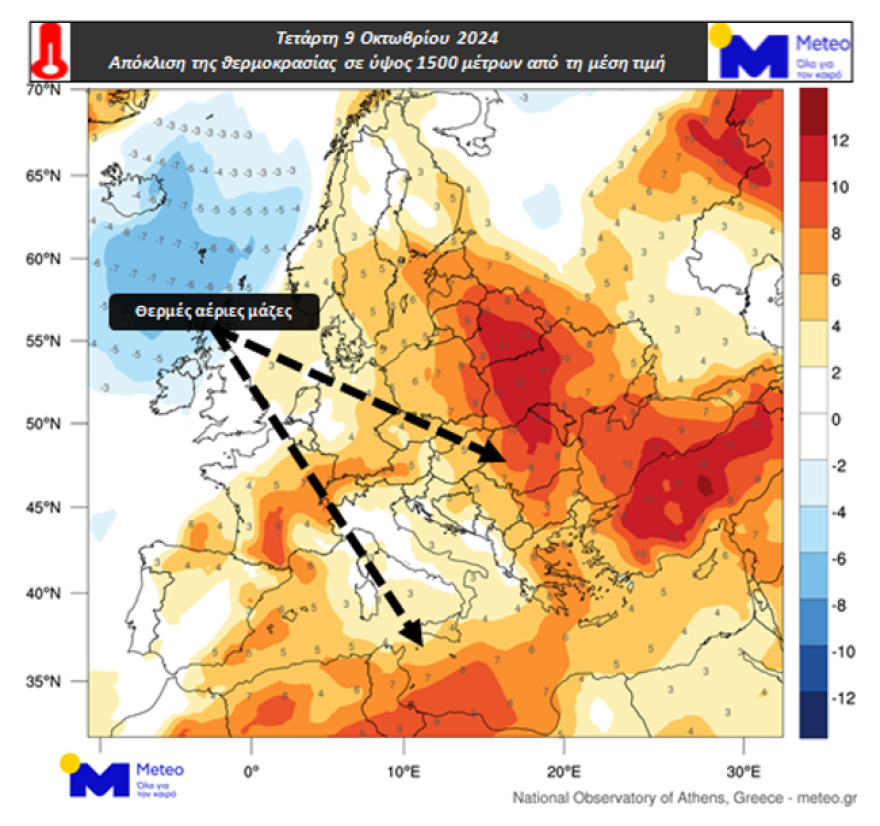
Maps 1 and 2 show the deviation of the temperature at an altitude of about 1500 meters from the average value of the period 1979-2010 for the noon of Wednesday 09/10 and Friday 11/10. The altitude of 1500 m is used to study temperature variations in the lower part of the atmosphere. Orange/red shades the areas where the temperature will be higher than the average climate value and blue/blue shades the areas where it will be lower. They typically show the warmest air masses over the central and eastern parts of Europe and the Mediterranean. It should be noted that the final configuration of the temperature near the ground depends on a number of factors such as the presence/absence of clouds and phenomena and wind.

The Little Summer of St. Demetrios
In a post, the director of the National Weather Service explains why these sunny and warm days of October are called “St. Demetrios’ little summer” and says there’s no sign of rain.
“The name “little summer of St Demetrius” is mentioned because the feast of St Demetrius from the earliest centuries of Christianity was a landmark festival for agricultural and livestock work. Especially for farmers, it marked the end of their stay in the mountains and the beginning of their multi-day march to the valleys of the plains. They would return to the mountains six months later, on St George’s Day.
Something similar, we notice, was happening in Greek Mythology. Persephone was returning to the darknesses of Hades, leaving behind her Demeter to lament her loss. The latter, in order to avenge herself, brought winter to the people. And the chrysanthemums – the “holy flowers” that bloom at this time of year even today are considered by many to be mourning flowers because, according to a folkloric interpretation, they appear to console Demeter for the departure of her daughter to Hades. The people wanted to exorcise fear of the coming winter, but also wanted to continue ancient beliefs in the new Christian reality. Be that as it may, the great feasts are “written” into people’s lives, giving their own meanings to everyday life and tasks.”
The weather today
Local clouds are expected at times on the mainland and in the Ionian Sea. Local showers and possibly sporadic thunderstorms will occur from the morning in the Ionian, western and northwestern mainland. Visibility will be locally limited until the morning.
The temperature in Western Macedonia will range from 9 to 25 degrees Celsius, in the rest of Macedonia and Thrace from 10 to 27, in Thessaly from 12 to 30, in Epirus from 12 to 25, in Sterea and Peloponnese from 11 to 30, in the Ionian islands from 14 to 23, in the North and East Aegean islands from 13 to 28, in the Cyclades and the Dodecanese from 13 to 26 and in Crete from 12 to 29 degrees Celsius.
From 12 to 12 degrees Celsius and from 12 to 12 degrees Cretaceous.
Winds in the Central and North Aegean will initially blow from variable directions up to 3 Beaufort but from the morning they will become south 3 to 5 Beaufort. In the South Aegean the winds will initially blow from westerly directions 3 to 5 Beaufort but from the morning they will become south to south-westerly of the same intensity. In the Ionian Sea the winds will blow from southerly directions 2 to 4 Beaufort.
THURSDAY 10-10-2024
In the Ionian islands, Epirus, western Sterea, the eastern Aegean islands, the Dodecanese and Thrace, clouds, partly cloudy with a few local showers until the afternoon. In the rest of the country, thin clouds at times more dense.
Visibility in the morning and evening hours will be locally limited and fogs may form.
Winds will blow south-southwest 3 to 5 Beaufort.
The temperature will rise slightly and will be 3 to 5 degrees above normal for the season, reaching 28 to 29 degrees and locally in the central and southern mainland and Crete 30 to 32 degrees Celsius.
FRIDAY 11-10-2024
In the west and north a few clouds, partly cloudy with local rain mainly in the northwest. In the rest of the country thin clouds at times thicker.
Visibility in the morning and evening hours will be locally limited and fog will form.
The winds will blow from southern directions 3 to 5 and in the Aegean Sea locally 6 Beaufort. Gradually in the west they will turn into western northwestern winds up to 5 Beaufort.
The temperature will drop slightly in the north, but in the central and southern regions it will remain high for the season, reaching 29 and in some places 31 degrees Celsius.
SATURDAY 12-10-2024
In eastern Macedonia, Thrace, the islands of the northern and eastern Aegean Sea and northern Evia a few clouds, partly cloudy with local rain and possibly in the northeast until noon isolated thunderstorms.
In the rest of the country a few clouds.
Visibility in the morning and evening hours will be locally limited.
Winds will blow north-northwest at 4 to 6 Beaufort, and by noon in the southeast from southerly directions up to 5 Beaufort.
The temperature will drop slightly in the north, but in other areas it will remain high for the season.
SUNDAY 13-10-2024
In the eastern mainland, Euboea, Cyclades and northern Crete a few clouds, partly cloudy with local rain. In the rest of the country generally clear with a few clouds.
Winds will blow from the north 3 to 5 and in the Aegean Sea locally 6 Beaufort.
The temperature will drop slightly.
Ask me anything
Explore related questions


