
Since yesterday, the weather has significantly worsened, with the storm continuing until the afternoon, mainly affecting western Greece, where heavy rain, thunderstorms, frequent lightning, and local hailstorms are occurring.
The ongoing storm in the western part of the country will end tonight, and a new one is approaching, expected to bring severe weather phenomena across Greece, including Attica, according to meteorologists.
The new weather front is expected from Friday and will impact eastern and southern Greece, bringing considerable cold and further temperature drops. By Sunday, the phenomena will shift towards the east and south, indicating that by the end of the week, almost no region will be spared from the rain.
EMY’s Emergency Weather Bulletin
The emergency weather deterioration bulletin issued on Monday has been updated with the latest forecast data. It is noted that there are no significant changes from the initial bulletin.
The worsening weather is expected to continue today, Wednesday (13-11-2024), mainly in western Greece, with heavy rain and thunderstorms accompanied by frequent lightning and local hailstorms.
Severe Weather Expected to Impact:
Today, Wednesday (13-11-2024), the entire Ionian region, Epirus, western Central Greece, the western Peloponnese, and possibly Thessaly.
Marousakis’ Forecast
ATTENTION IN THE COMING HOURS
The latest data from our forecasting systems indicate a shift in the storm’s path, suggesting that, in addition to the western coastal areas, southern coastal regions such as the southern parts of the Peloponnese, extending towards the Myrtoan Sea and the Cyclades, are also likely to be affected.
Tsatrafilias’ Forecast on Rainfall
Areas likely to experience water quantities close to 100 tons per hectare (thus, at risk of sudden flooding) until the afternoon include Zakynthos, Kefalonia-Ithaca, Lefkada, Achaia, Ilia, Aetolia-Acarnania, and Preveza.
Significant Rainfall in Western and Southern Regions Yesterday
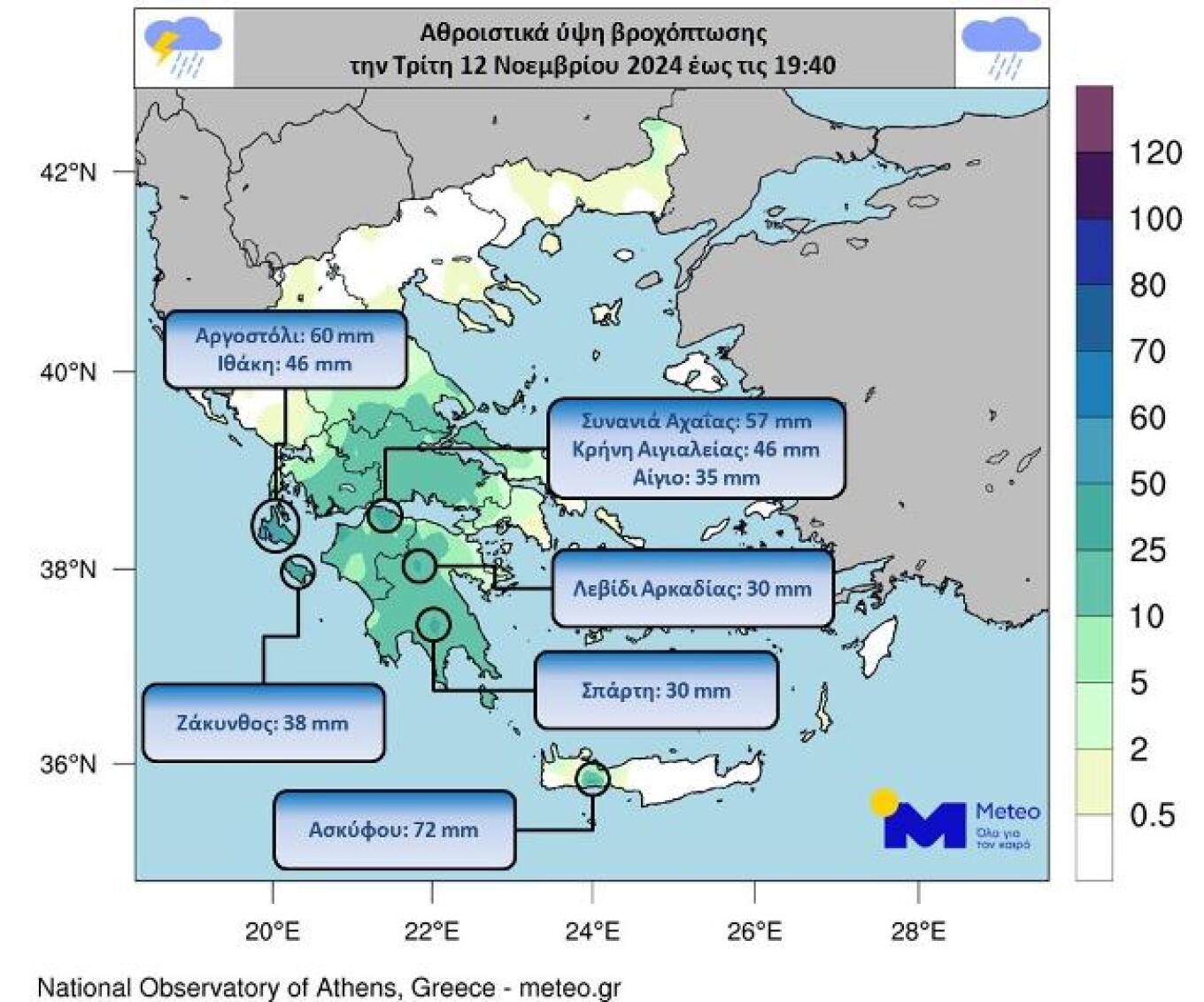
Notable rainfall occurred throughout Tuesday, November 12th, with intense localized phenomena, including thunderstorms, in the western regions and Crete. The following map shows cumulative rainfall levels up to 19:40 on Tuesday, November 12th, as recorded by 510 meteorological stations of the National Observatory of Athens/meteo.gr, highlighting indicative rainfall heights.
Today’s Weather
Rainfall is expected in the Ionian Islands, most mainland areas, the Sporades, the North Aegean islands, and possibly briefly in parts of the Cyclades and the Eastern Aegean. The phenomena will be more intense in the Ionian Islands and mainland parts of Western Greece, where thunderstorms and potentially local hailstorms are expected. Atmospheric circulation favors dust transport, mainly affecting the western, central, and southern parts of the country.
Temperatures will range from 1 to 10 degrees Celsius in Western Macedonia, 4 to 13-14 in the rest of northern Greece, 7 to 14-15 in Thessaly, 10 to 20 in Epirus, 10 to 20-22 in the rest of the mainland, 14 to 20 in the Ionian Islands, 8 to 16-17 in the North Aegean islands, 11 to 22-23 in the other Aegean islands and Crete, with local highs of up to 25-26 degrees Celsius in Crete.
In the North Aegean, winds will be from the east-northeast at 4-5 Beaufort, while in the rest of the Aegean, they will be from the east at 3-5 Beaufort. In the Ionian, south-southeast winds will blow with intensities of 5-6 Beaufort.
Ask me anything
Explore related questions