Low temperatures and gusty north winds will be the main features of weather at the weekend as a polar vortex brings a 48-hour heavy winter to the European south as well, forecasters predict.
According to EMY director Thodoros Kolydas, a big drop in temperature of 10 degrees Celsius (locally more) is expected on Saturday. Precipitation heights will be reduced and will not be able to provide significant snowfall based on current data.
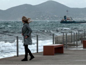
For his part, Giorgos Tsatrafyllias characterizes “the drop in temperature in our country this weekend as the position of the polar air pocket favors the transfer of very cold air masses from the northernmost latitudes to our country. On Sunday and Monday morning many major cities will “wake up” with temperatures below 10 degrees Celsius, such as Athens, Thessaloniki, Larissa, Trikala, Argos, Chalkida, Ioannina, Patras and Nafplio. Also the gusty north winds that will reach 9 Beaufort will not only create problems for sea transport but will cause a greater sense of cold. However, from Tuesday onwards, the winds will drop, the weather will improve and the temperature will rise.”
Enhanced southerly winds and notable rainfall Thursday
Strengthened southerly winds prevailed until noon on Thursday 21/11 in the Aegean Sea and in continental areas. The strongest gust was recorded in Paximada Karystos and was equal to 108 km/h. Table 1 presents the 8 stations of the meteo.gr / National Observatory of Athens network of automatic weather stations that recorded the strongest wind gusts until the afternoon of Thursday 21/11.
At the same time, there was considerable rainfall, mainly in the western mainland. The largest amount of cumulative precipitation until the afternoon of Thursday 21/11 was recorded in Theodoriana Arta and was equal to 44 mm. Table 2 shows the 8 stations of the network that recorded the highest cumulative precipitation up to the afternoon of Thursday 21/11.
The weather today
Clouds are expected in the west, southwest and northwest, gradually expanding to the rest of the country. Rains will initially occur in the west, southwest and northwest, which from the afternoon will extend in places to the northern mainland, the Aegean islands and Crete. Sporadic thunderstorms are expected mainly on the Ionian islands in Epirus and Western Sterea, while from the afternoon there is a possibility of sporadic thunderstorms in Thrace and the islands of the Eastern Aegean. Dust concentrations in the atmosphere will be relatively high in Crete and the Dodecanese. Visibility on the mainland will be locally limited until the morning.
The temperature in Western Macedonia will range from 0 to 17 degrees Celsius, in the rest of Macedonia and Thrace from 0 to 18, in Thessaly from 4 to 21, in Epirus and Western Central Greece from 7 to 20, in the rest of Central Greece from 5 to 20, in the Peloponnese from 5 to 20, in the Ionian islands from 13 to 20, in the North and East Aegean islands from 7 to 20, in the Cyclades from 10 to 21, in the Dodecanese from 14 to 21 and in Crete from 13 to 25 degrees Celsius.
The winds in the North Aegean will initially blow from eastern directions from 2 to 4 Beaufort but from the morning they will turn to southern 3 to 5 Beaufort, while in the afternoon they will strengthen and will blow from southern directions from 5 to 7 Beaufort. In the Central Aegean Sea the winds will initially blow from variable directions up to 3 Beaufort but from the morning they will become southerly 2 to 4 Beaufort while from the afternoon they will strengthen and blow from southerly directions 4 to 6 Beaufort. In the South Aegean Sea the winds will initially blow from westerly directions 2 to 4 Beaufort but from the morning they will shift to southerly 3 to 5 Beaufort. In the Ionian Sea the winds will blow from the south to southwest 3 to 5 Beaufort and from the morning 4 to 6 Beaufort. Towards the evening in the Central and Northern Ionian Sea the winds will shift to west to northwest 4 to 6 Beaufort.
SATURDAY 23-11-2024
Cloudy, with showers and thunderstorms in the Ionian Sea, the western, central and northern mainland, the eastern Aegean islands, western Crete and occasionally in other areas. However, from the morning hours in the Ionian Sea and from mid-morning onwards gradually in the mainland, almost clear weather is expected, while gradually from the afternoon the weather will improve in the Aegean Sea. Occasional snowfall will occur in the northern mountains and until the morning hours in western Macedonia.
The winds will initially blow west southwest 5 to 6, in the seas 7 and locally in the northern Aegean 8 Beaufort. From the morning hours in the Ionian Sea, from the midday hours in the mainland and gradually in the Aegean Sea they will turn to north 6 to 8 Beaufort.
The temperature will drop initially in the north and central areas and from the afternoon in the rest of the regions. It will reach up to 12 degrees Celsius in the northwestern mainland, 13 to 16 degrees in the rest of the northern and central mainland and 17 to 18 degrees in the east, 19 to 22 degrees Celsius in the rest of the country and 23 degrees Celsius in Crete and the Dodecanese. The minimum temperatures will range in the northern and central lowlands around -1 (minus one) to 4 degrees Celsius. It is noted that by the evening the drop in temperature will be felt throughout the country.
SUNDAY 24-11-2024
Generally clear weather and only locally in the Aegean Sea and the eastern mainland there will be occasional local clouds.
The winds will blow north northeast, in the west 3 to 5 Beaufort, initially in the east 5 to 6, in the Aegean 6 to 7 and in the southernmost parts of the Aegean 8 and possibly locally 9 Beaufort. From the morning hours they will gradually weaken and only in the southern Aegean Sea they will reach 7 to 8 Beaufort.
The temperature will drop further across the country. It will reach 11 to 13 degrees Celsius in the central and northern regions, 14 to 15 degrees Celsius in the rest of the country and only in the western part of the country and the southernmost parts of the Aegean Sea will reach 16 to 17 degrees Celsius locally. In the morning hours, mainly in the northern mainland, there will be frost in the northwest.
Ask me anything
Explore related questions