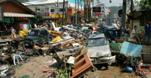
Twenty years passed a few days ago, on December 26, since the most devastating tsunami on record. The deadly event, which occurred the day after Christmas 2004, claimed the lives of nearly 230,000 people and affected dozens of countries bordering the Indian Ocean.
On December 26, 2004, a 9.2 magnitude earthquake off the coast of Sumatra caused huge waves that swept through countries such as Indonesia, Sri Lanka, India, Thailand and nine other regions. The seismic waves reached speeds of up to 800 kilometers per hour and heights of 30 meters, wreaking destruction and death. According to EM-DAT, the global database on natural disasters, the tsunami left 226,408 victims in its wake. The hardest-hit area was the northern part of Sumatra, with 120,000 dead, the most of the 165,708 mourned by Indonesia as a whole.
Experts note that the absence of an effective early warning system in 2004 exacerbated the tragedy. Since then, many countries have invested in such systems to prevent similar disasters in the future.
Lessons learned from 2004 – How ready is Greece for a tsunami?
On the occasion of the “black” anniversary of the 20th anniversary, Professor Kostas Synolakis, Professor of Natural Disasters, analyses the conclusions of that tragedy and asks whether Greece is ready to face a similar -expired- scenario.
“Twenty years ago today an earthquake measuring 9.2 on the Richter scale struck northwest of Sumatra,” he says. “After the 9.5 magnitude earthquake in Chile in 1960, it was the second largest on record and moved a piece of seabed the size of Greece, about 11 meters laterally and 5 meters vertically. After the earthquake, I spent about three months on field missions in the Indian Ocean as a UNESCO representative, studying what happened and lecturing in schools, hospitals and civil protection offices. The earthquake triggered a major tsunami that killed at least 230,000 people in Sumatra, Thailand, Sri Lanka, India, the Maldives and East Africa. The tsunami rose to a height of about 35 meters in Banda Aceh.”
What went wrong
What went wrong then? Everything, says Kostas Synolakis. There was no warning because at the time the Indian Ocean was not considered vulnerable to tsunamis and the warning centers in the Pacific had no protocols for providing warnings to Indian Ocean countries. The initial magnitude estimate was 8.2, because it was based on the first three minutes of the shaking, the algorithms were not programmed for longer duration.
India did not issue a timely evacuation order on its coast even after the tsunami caused major damage in Port Blair in the Andaman Islands, two hours before it hit the mainland. In Thailand, visitors were exploring the exposed seabed when the coastline was pulled back with the arrival of the tsunami. In Sri Lanka, tourists took pictures on the beach with the tsunami advancing behind them, believing they could not outrun the tsunami. In the Maldives, men ordered women and children to stay in their homes (single-story dwellings) while they explored the strange noise made by the tsunami’s advance.
Recovery from the disaster was rapid, but so was the upgrading of preparedness. The Pacific Tsunami Warning Center began providing warning services to Indian Ocean countries. I and other scientists worked in hyper drive to identify other high-risk zones around the world to avoid deadly surprises.
I then coordinated efforts by the US National Oceanic and Atmospheric Administration (NOAA) in collaboration with UNESCO to train scientists from Indian Ocean countries, emergency center managers, on how to do risk assessment studies and how to educate their fellow citizens. We also turned NOAA’s tsunami flood forecasting technology into a web-based platform to produce flood maps for evacuation planning and labeling by scientists around the world.
Prior to 2004, there were only six tsunamographs in the Pacific. These are buoys anchored in the open oceans and linked by acoustic signals to ocean-bottom pressure recorders, then transmit the information to satellites, which in turn transmit the information to warning centers. When an undersea earthquake occurs, they are used to confirm the size of the tsunami. There are currently about 60 in the Pacific and Caribbean, and another ten in the Indian Ocean, but none in the Mediterranean.
Are we better prepared?
Are we better prepared? The December 5, 2024 magnitude 7.0 earthquake off Northern California generated only one nano tsunami, about 5 cm when it made landfall. A tsunami warning was issued in five minutes-let’s see what happened.
The United States Geological Survey (USGS) system, which tries to provide an early warning a few seconds before one feels the tremor, worked almost flawlessly. Wireless emergency notification, namely 112, was activated, and millions of residents in coastal areas from San Francisco to central Oregon received text messages, marking the first time such a warning has been transmitted in this way in the US – in Greece the first such warning was issued in 2020 in the Samos earthquake and arrived before the main tsunami wave.
What didn’t work so well in California was that the alert reached hundreds of thousands more people than had to be evacuated, given the small size of the quake.
Clearly we need improvements in technology so that we don’t rely on earthquake detection alone. Machine learning can be useful in providing worst-case flooding estimates, leading to targeted warnings and effective evacuations of at-risk areas.
It is equally obvious that education of coastal residents needs to be intensified; residents need to know how much time they have to evacuate, where to go, and how to be guided by signs to get there. This requires preparation, preparation, preparation.
Where we are in Greece
But let’s look at where we are in Greece. Except for Samos, there are no signs indicating danger zones and evacuation routes, Mr. Synolakis points out, as many municipalities mistakenly believe that signs will discourage tourists. Hawaii, which is one of the most tourist-successful areas in the world, has signs everywhere, even though the last major tsunami was in 1960. In Greece it was the 1956 Amorgos tsunami.
In the Aegean, with over 200 inhabited islands and tens of millions of tourists every year, there are currently only ten tide gauges, instruments that measure the water level in ports and are really useful for detecting the size of a tsunami – tsunamographs measure the level in the open sea, and we have none. This is where the state and local communities need to take responsibility, because, in addition to that, tide gauges are also very useful for assessing the effects of climate change.
We do not have offshore cabled seismographs that provide more timely and accurate estimates of the magnitude of underwater earthquakes, especially in southern Crete which has some of the highest risks in Greece, because there are no accessible seismographs on the global network in North Africa. There are no plans to install seismographs when laying undersea communication cables, which is now routine elsewhere.
At best, preparedness drills are held once a decade, rather than evacuation drills every 1-2 years in the highest risk areas, as is done in Japan, California, Hawaii and Chile. Crete had the Greek exercise “Minos” in 2023 and the international exercise “Poseidon” in 2011. Nowhere have there been any real evacuation exercises (except for a few schools), despite the national tragedy in Mati. Samos is an exception.
The only positive thing is that 112 is working, but as we are essentially blind, we are at risk from an undersea earthquake in the central Aegean to evacuate all the beaches of our islands because we do not have the measuring and computing tools we need to better determine the risk.
Targeted and early warnings are technologically feasible everywhere. Forecasting tsunami inundation is now a routine calculation using NOAA technology. There is no excuse for any region in the world not to have hazard and evacuation maps. In Greece, as we saw in Thessaly last year, we are also at risk from ignorance of the consequences of ignorance. Civil Protection in our country has announced large funding for the production of early warning and information systems, but without so far involving the scientific community in terms of specifications and capabilities. We need the search for global best practices and not only our own “patents”, we do not know everything.
“We learned about 112 because the then Deputy Secretary General of Civil Protection George Karagiannis and I stepped forward, despite the strong reactions at the time,” says Kostas Synolakis.
Until we have targeted warnings in less than five minutes, as we had in California, we need to know that if we are near the coast (anywhere in the world) and feel a tremor that lasts more than fifteen seconds, or observe unusual sea movements, such as rapid rise or rapid retreat, we should immediately move to an elevation of at least 10 meters and wait there for instructions from the authorities. In this way we will avoid the bad fate of our fellow human beings who died on their exotic holidays 20 years ago.
Kostas Synolakis is a full member of the Academy of Athens and the US National Academies, and a professor at the University of Southern California.
Ask me anything
Explore related questions