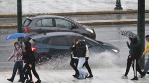
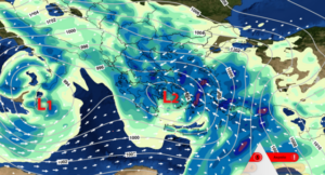
The weather over the next few days will generally be good. Saturday will see showers and thunderstorms across most of the country and on Sunday, the weather will subside, followed by clear weather on Monday, the day of Epiphany, with the scene likely to remain the same through the first 10 days of January.
“With temperatures above normal, the first ten days of January will pass with a temporary drop in mercury next weekend and a few showers. Temperatures retreat towards the middle of the month, with more showers. Happy New Year,” says EMY director Thodoris Kolydas in a post on X (formerly Twitter).
Alcyonide days may be expected early in the New Year, but this will not be the case for all areas of the country. Tassos Arniakos gives the first insight into the cold invasion that meteorologists estimate will come to our country.
Specifically, according to him, rains will continue over the weekend and on Christmas Day in western and eastern regions of the country. Forecast models are still divided on the extent and intensity of the cold invasion and when exactly it will affect our country, with Tasos Arniakos clarifying, however, that a lot of cold is concentrated in northern Europe.
In his forecast, Sakis Arnaoutoglou says that the weather will be good on Epiphany, but from Tuesday (7/1) there will be a new change, with rain in western Greece. At the same time, there are continuing signs of a lot of “winter cold” accumulating in the Balkans after January 10-11.
“There is a possibility that these colder air masses will descend on several areas of our country. If this happens, why not have snow surprises, depending on how this cold weather is combined,” according to Arnaoutoglou.
For his part, Giorgos Tsatrafyllias notes the following:
“Will cold weather come in January? Happy New Year! With mild weather conditions both on land and at sea we are heading towards Epiphany. However some showers are expected mainly in the west, south and eastern Aegean over the weekend, with temperatures dropping a little. However, the long term forecast for January from two major centers ( NOAA, ECMWF) does not give us a cold signal. On the contrary, the temperature will be above normal by about 1 degree. Let’s see…”.
The weather today
Localized showers are expected in parts of the Western mainland and the Ionian Islands, the islands of the Eastern Aegean, the Dodecanese and the Cyclades. Sporadic thunderstorms will mainly occur in the islands of the Eastern Aegean and the Northern Dodecanese. At night and early in the morning in the northern mainland, frost will occur, while in many areas of the country visibility will be limited.
The temperature will range in Western Macedonia from -5 to 10 degrees Celsius, in the rest of northern Greece from -2 to 12-14 degrees Celsius, in Thessaly from -2 to 15-17 degrees Celsius, in Epirus from 2 to 14-15 degrees Celsius, in the rest of the mainland from 3 to 14-16 degrees Celsius, in the Ionian Islands from 6 to 15 degrees Celsius, in the North Aegean islands from 3 to 14 degrees Celsius and in the rest of the Aegean islands and in Crete from 7 to 16-18 degrees Celsius.
In the Aegean Sea the winds will blow from the south-west at 4-5 Beaufort and possibly at times up to 6 Beaufort. In the Ionian Sea the winds will blow from the west southwest with an intensity of 3-5 Beaufort.
In Attica we expect some clouds. At night and early in the morning the visibility will be limited. Winds will blow south southwest with intensities up to 4 Beaufort. The temperature will range from 7 to 14-15 degrees Celsius.
In Thessaloniki we expect a few clouds. At night and early in the morning the visibility will be limited. Winds will blow from variable directions with intensities of 2-3 Beaufort. The temperature will range from 3 to 13 degrees Celsius.
The weather on Saturday 04-01-2025
Increased clouds and mainly in the west and the eastern and southern Aegean with showers. Sporadic thunderstorms will occur in the southeast (Dodecanese – Crete area). Occasional snowfall will occur in the mountains of Epirus and Macedonia. In the evening the phenomena will stop in the Ionian and most continental areas.
Winds in the southeast will blow south southeast at 3 to 5 Beaufort. In the rest of the country the winds will initially be westerly southwesterly 3 to 5 Beaufort, but quickly in the west and north and gradually in the rest of the country they will turn to northerly directions and in the northeastern Aegean Sea they will increase to 5 to 6 Beaufort.
The temperature will drop in the north where it will not exceed 9 to 11 degrees Celsius, while in other areas it will reach 15 to 17 degrees Celsius and locally in the southern Aegean 18 degrees Celsius.
The weather on Sunday 05-01-2025
In the Cyclades, Crete and the Dodecanese clouds with local rain and occasional thunderstorms are forecast, but the weather will gradually improve. In the rest of the country a few clouds, partly increasing in the morning hours, when there will be light showers in the Sporades and Evia.
Winds will blow from the north from 3 to 5 and in the Aegean Sea locally 6 Beaufort.
The temperature will drop slightly in the south. In the northwest in the morning hours there will be local frost.
The weather on Monday 06-01-2025 (Epiphany)
Nearly clear weather all over the country. From the afternoon clouds in the west and north. Visibility in the morning hours will be locally limited and fog will form.
Winds will initially blow from the north at 3 to 5 Beaufort, but will gradually shift to west southwest and at night in the northern Ionian Sea south southeast winds up to 6 Beaufort will prevail.
The temperature will rise all over the country, mainly in terms of maximum values.
The weather on Tuesday 07-01-2025
Clouds, locally increasing mainly in the west and the islands of the eastern Aegean Sea where local rain and occasional thunderstorms will occur.
Winds will blow south-southwest 4 to 5 and in the sea locally 6 Beaufort.
The temperature will not change significantly.
Ask me anything
Explore related questions


