Temperatures will remain slightly below normal for the season today with more rain and heavy snowfall at altitudes of 300-400 meters, mainly from the Peloponnese and further north. From Thursday 13/2, snow will be reduced and rain will be the dominant feature of the weather.
According to OPEN’s meteorologist Klearchos Marousakis for Tsiknopempti (20/2), the cold will be felt, with quite low temperatures and possible rainfall in most areas of the country, while he speaks of a polar descent next week.
For his part, EMY director Thodoros Kolydas said in a post that “more rain is coming in the next few days. Otherwise, temperatures may return to normal in the middle of the month, but this will not last long, as a new (smaller) drop in temperature is predicted.”
Temperature approached -10 °C yesterday morning
Very low minimum temperatures were recorded in the morning hours of Tuesday 11/02 in several continental areas, with the lowest minimum temperature recorded in Paranesti, Drama, at -9.9°C. According to the network of automatic weather stations of the National Observatory of Athens / meteo.gr the eight lowest minimum temperatures of the day are presented in the table below.
Today’s weather
Increased clouds are forecast with local rain, which will intensify in the Ionian Sea from midday. Snowfall will occur in the mountainous areas of the mainland, Evia and Crete, in Western Macedonia, in semi-mountainous areas of Central and Northern Greece and occasionally in areas with lower altitude in Thessaly and Central Macedonia. Visibility will be limited in the central and northern mainland, while frost will occur overnight and early in the morning in the mainland.
The temperature will range in Northern Greece from -6 to 9 degrees, in Epirus from -3 to 13 degrees, in Thessaly from -2 to 9 degrees, in the Peloponnese from -2 to 12 degrees and in Sterea from -2 to 11 degrees, in the North Aegean islands from 2 to 10 degrees, in the Central and South Aegean from 5 to 12 degrees, in the Ionian Sea from 6 to 14 degrees and in Crete from 6 to 13 degrees.
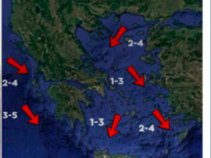
Winds will blow in the West from southeastern directions from 3 to 6 Beaufort, in the East from northern northeastern directions from 3 to 5 Beaufort and in the Southeastern Aegean up to 6 Beaufort.
In Attica, partly cloudy with light local rain is forecast. Winds will blow from the north northeast at 3 to 5 Beaufort. The temperature will range from 4 to 10 degrees Celsius.
In Thessaloniki increased clouds are forecasted. The winds will blow from east southeast directions with intensities up to 4 Beaufort and the temperature will range from 2 to 9 degrees
The weather on Thursday 13-02-2025
Cloudy with local rain in the Ionian Sea, the mainland, western Crete, from noon in Evia, Sporades, the rest of Crete and from the evening in the Cyclades. Sporadic thunderstorms will mainly occur on the Ionian Islands, western Sterea and western and southern Peloponnese. Snowfall will occur in the mainland mountains and in the mountains of northern Evia.
Winds will blow in the west southeast 4 to 6 and in the Ionian Sea locally 7 Beaufort. In the east will blow from the north 3 to 5 Beaufort, but will gradually change to south southeast winds up to 4 Beaufort.
The temperature will rise slightly in the west and south. In the Ionian Islands, the western and southern mainland, Crete, the Dodecanese and the Cyclades it will reach 13 to 15 degrees Celsius, while in the north it will reach 8 to 11 and in the rest of the country 11 to 13 degrees Celsius. Frost will occur in places in the central and northern mainland in the morning and evening hours.
The weather on Friday 14-02-2025
Increased clouds with local rain mainly in the Ionian Sea, the western and southern mainland, the Cyclades and the islands of the eastern Aegean. Sporadic thunderstorms will occur in the Ionian Sea, the western mainland and probably from noon onwards in some places in the Cyclades and the eastern Aegean. Light snowfall will occur in places in the continental highlands. Visibility in the morning hours will be locally limited.
Winds will blow from southern directions 3 to 5 and locally in the sea 6 Beaufort.
The temperature will rise and return to normal for the season.
The weather on Saturday 15-02-2025
Across the country, cloudy skies are forecast, with localized showers. Sporadic thunderstorms will occur mainly in the Ionian Sea and on the islands of the eastern Aegean. Snowfall will occur in places mainly in the central and northern continental mountains.
Winds will blow from southerly directions 3 to 5 and locally in the sea 6 Beaufort, but from the afternoon in the north – northeast will shift to northerly directions and will increase to 6 to 7 and locally at night in the northeastern Aegean 8 Beaufort.
The temperature will not change significantly. Frost will occur locally in the northern mainland in the morning and mainly in the evening hours.
The weather on Sunday 16-02-2025
In the Ionian and the western mainland, gradually in the rest of the mainland, Evia and the islands of the northeastern Aegean, increased clouds with local rain and occasional thunderstorms are forecast. In the rest of the country cloudy at times with local showers. Snowfall will occur in places mainly in the central and northern continental mountains.
The winds will blow from southern directions 4 to 5 and in the sea locally 6 Beaufort, in the northeastern Aegean east northeastern 3 to 5 Beaufort.
The temperature will rise slightly in the south.
Ask me anything
Explore related questions


