
Weather continues with heavy rains from late yesterday afternoon in the Ionian Sea, coastal areas of Epirus, western Sterea, and the western and southern Peloponnese
According to meteorologist Thodoris Kolyda, the main part of the disturbance affected the Ionian Islands and western mainland shortly after midnight, moving eastward. He presented the system’s occlusion and hourly rainfall data.
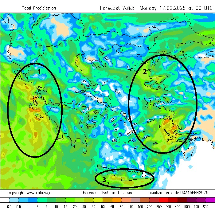
Clerchos Marousakis shared a rainfall map for the next 48 hours, highlighting areas with the heaviest rainfall. “Unfortunately, these areas include those affected by the previous weather disturbance. Generally, coastal areas seem to be at the highest risk. The data comes from our regional forecasting system ‘THESEAS,’ fed by our global forecasting system ‘HERCULES.’ We must remain cautious!” said the OPEN meteorologist.
Meteorologist Giorgos Tsatrafyllias mentioned that heavy storms will continue in western Greece until morning, particularly in areas such as Lefkada, Zakynthos, Kefalonia, Ithaca, and coastal areas of Aetolia-Acarnania, Achaia, Messinia, and Ilia.
Kefalonia (mainly its southern and southeastern parts), Zakynthos, and southwestern Peloponnese are in the highest risk areas for flooding and landslides. Southern Peloponnese will experience heavy rains just before noon.
The intensity of the weather will be less than yesterday, but in already saturated areas, problems could arise. By Sunday after 12:00 noon, conditions will improve, said the Alpha meteorologist.
Emergency Weather Bulletin from the National Meteorological Service (EMY)
From the early hours of Sunday (February 16, 2025), strong weather will affect the eastern Peloponnese, parts of western and southern Crete, the Cyclades, and the northeastern Aegean.
A gradual weakening of the weather phenomena is expected starting from the afternoon on Sunday, first in the western regions and later in other areas.
112 Alerts in Western Greece and the Peloponnese
The 112 emergency alerts were sent on Saturday afternoon warning of the impending bad weather. The messages notified citizens of strong rains and thunderstorms during the night on Saturday (February 15) and Sunday noon (February 16) in western Sterea and the western and southern Peloponnese.
Alerts were also sent to Lefkada, Ithaca, Kefalonia, Zakynthos, and coastal areas of Epirus.
Citizens are urged to exercise caution when traveling during the weather event and follow the authorities’ guidelines.
Weather Forecast for Today
Increased cloudiness and local rain are expected in most parts of Greece. Scattered thunderstorms will occur in the West, the Peloponnese, the Northern and Eastern Aegean, the Cyclades, and Crete.
Temperatures will range from 5-13°C in Eastern Macedonia and Thrace, 2-10°C in Western Macedonia, 5-14°C in Epirus, 7-15°C in Thessaly, 5-16°C in the Peloponnese, and 5-17°C in Central Greece. The islands of the Northern Aegean will have temperatures between 10-16°C, while the South Aegean will experience 8-17°C. The Ionian Islands will range from 10-17°C, and Crete will see temperatures from 9-18°C.
Winds will be southerly at 4-6 Beaufort in the Ionian, 5 Beaufort in the Aegean, and north-northeast at 3-5 Beaufort in the Northeast.

Weather on Monday, February 17, 2025
Cloudy skies with rain are expected in Central and Eastern Macedonia and Thrace, extending to Western Macedonia and Thessaly by afternoon. The eastern Aegean, the Dodecanese, and early morning rain in the Cyclades and Crete will see occasional showers and storms. The rest of the country will experience brief periods of increased cloud cover and short-duration rain in Epirus, Sterea, and Evia. Snow is expected in higher altitudes of the northern mainland, and in some northern and eastern areas, snow may fall in lower regions as well.
Winds will come from northern directions at 3-5 Beaufort, and in the northeastern areas, winds will reach 5-6 Beaufort. In the eastern Aegean, winds will be southerly at 4-5 Beaufort.
Temperatures will drop in the northeast, where they will not exceed 8-10°C. The rest of the country will see temperatures ranging from 11-13°C in the north, 14-16°C in the central parts, and up to 16-18°C in the south.
Weather for Tuesday, February 18, 2025
Cloudiness and local rain are expected in Eastern and Northern Greece and the Aegean. Snowfall will occur in the central and northern mountainous areas and in lower elevations of northern Greece. There will also be light showers in other parts of the country. Visibility will be reduced in the morning, with fog in certain areas.
Winds will be from northern directions at 3-5 Beaufort, with localized gusts of 6 Beaufort in the Aegean.
Temperatures will drop in the central and northern parts of the country, and frost is expected in certain inland northern areas.
Weather for Wednesday, February 19 and Thursday, February 20, 2025
Increased cloudiness with local rain is expected in the eastern and southern mainland, the Sporades, Evia, Crete, and occasionally in the northern parts of mainland Greece and the northern Aegean islands. Snow will fall in the mountainous areas, with lower elevations in northern Greece possibly seeing snow as well. Conditions will gradually improve by Thursday. The rest of the country will experience few clouds with occasional increased cloudiness.
Winds will be from northeastern directions at 4-6 Beaufort, and in the Aegean, gusts could reach 7 Beaufort. The Dodecanese will see north-northwesterly winds at 6-8 Beaufort.
Temperatures will drop across the country, and frost is expected in the central and northern mainland.
Ask me anything
Explore related questions