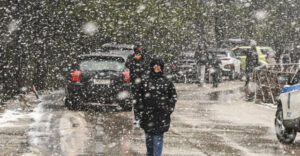
The cold invasion has been underway since last night, having draped several areas of northern Greece in white. From the early morning hours snowfall will also occur in the mountainous and semi-mountainous parts of Central Greece. Still, rainfall will occur in most of the country and sporadic thunderstorms in the northeast, while the phenomena will begin to weaken from the afternoon.
In addition, the temperature drop, which is expected to be in the order of 10°C, will be felt most today in the central and northern parts of the country. From Tuesday 08/04 the rest of Greece will be affected, while frost will persist in many areas of the northern part of the country, mainly in the morning and evening hours, until Friday 11/04.
According to the updated Special Weather Forecast issued on Saturday (05-04-2025)
Sometimes heavy rain and thunderstorms
– On Monday (07-04-2025) until noon on the islands of the East Aegean.
– Locally heavy rain in the morning hours of Monday (07-04-2025) in eastern Thessaly, Sporades and northern Evia.
In some places heavy snowfall
– Until noon on Monday in the mountains and semi-mountains of Thrace and Macedonia (areas with an altitude of 400 meters and above) and locally in the prefecture of Evros and in lowland areas.
– In the morning hours of Monday (07-04-2025) in the mountains of Epirus and Thessaly.
Noticeable drop in temperature in Macedonia and Thrace and gradually today and Tuesday in central and southern Greece. Frost in northern Greece in the evening hours of Monday (07-04-2025) and in the interior of all mainland Greece in the morning and evening hours of Tuesday and Wednesday and in the morning hours of Thursday.
Florina, Drama, Kastoria, Kozani and Thessaloniki
Florina has been dressed in white since yesterday evening, as there was heavy snowfall even in the city. In fact, schools will open today at 9:15 in the morning by decision of the mayor of the city.
Shortly before 2 a.m. Monday morning, it started snowing in Thessaloniki, as seen in this video from Forecast Weather.
Heavy snowfall from late Sunday night in Kastoria, Kozani and Drama.
Thodoros Kolydas says in a post that in Florina “in just 6 hours the temperature dropped by 15 degrees.”
Hail in Halkidiki
Heavy hail occurred yesterday in northern Halkidiki, with the phenomena being particularly intense in the area of Paleochori and Megali Panagia.
As seen in the video by ergoxalkidikis.gr, hail covered the road from the road connecting the two villages. Drivers were forced to reduce speed due to the slipperiness, while the intensity of the hail caused a temporary reduction in visibility.
The weather forecast until Friday 11/4
Monday 7/4
WARNINGS
Heavy showers and thunderstorms on the eastern Aegean islands until midday.
Heavy rain in the morning hours in eastern Thessaly, Sporades, and northern Evia.
Noticeable drop in temperature and occasional heavy snowfall in the morning hours in the mountains of Thessaly and Epirus and until noon in the mountains and semi-mountains of Macedonia and Thrace with an altitude of 400 meters and above and locally in the prefecture of Evros and in lowland areas. Frost in the northern part of the country in the evening hours
GENERAL CHARACTERISTICS
Clouds, partly increasing in most of the country with local rain and in the east sporadic thunderstorms. The phenomena will be locally strong until the morning in eastern Thessaly, the Sporades and northern Evia and until noon on the islands of the eastern Aegean.
Snowfall will occur in the northern mountains – semi-mountains which will be dense in the morning hours in the mountains of Epirus and Thessaly and until noon in areas of Macedonia and Thrace with an altitude of 400 meters and above and locally in the prefecture of Evros and in lowland areas.
The phenomena will gradually weaken from the afternoon in most areas of the northern part of the country and will stop in the west.
The winds will blow from the north 4 to 6 and in the seas locally 7 Beaufort and only in the southern Aegean Sea until noon will prevail southwest winds 4 to 6 Beaufort.
The temperature will drop significantly in the central and northern regions, where it will reach 10 to 14 degrees Celsius. In the rest of the country 17 to 19 degrees Celsius and in Crete 20 to 21 degrees Celsius. Frost will occur in the evening hours in the northern mainland.
Tuesday 8/4
In the eastern part of the country increasing cloudiness with local rain and in the south isolated thunderstorms. In the rest of the regions a few clouds in some places. Winds will blow north northeast 4 to 5 and in the sea locally 6 Beaufort.
The temperature will drop slightly further and in the central and northern areas will be low for the season. Frost will occur in the morning and evening hours in the central and northern continents.
Wednesday 9/4
In the west and south, increasing clouds with local rain and, mainly in the Peloponnese, isolated thunderstorms. In the rest of the country a few clouds, partly increasing in the midday and afternoon hours on the mainland. A little snow will fall in the mountains. Winds will blow north-northwest 4 to 6 and in the sea locally 7 Beaufort. The temperature will not change significantly and will remain low for the season. Frost will occur in the morning and evening hours on the mainland.
Thursday 10/4
A few clouds, partly cloudy, initially in the east and from midday on the mainland with a chance of local rain. Some snow will fall in the mountains. Winds will blow north-northwest 4 to 5 and in the southeast 6 locally 7 Beaufort. The temperature will rise slightly towards the maximum. Frost will occur in the morning hours on the mainland.
Friday 11/4
A few clouds, partly cloudy, initially in the east and from midday on the mainland with a chance of local rain in the southern mainland, Crete and the Aegean islands. Winds will blow north-northwest 4 to 5 Beaufort and occasionally 6 to 7 Beaufort. The temperature will rise slightly. Frost will occur in the morning hours on the mainland.
Civil Protection’s recommendations to citizens in view of bad weather
The Civil Protection is making recommendations to citizens, in view of the worsening weather, to be particularly careful, ensuring that they take measures to protect themselves from the risks arising from the onset of severe weather phenomena.
The General Secretariat of Civil Protection (civilprotection.gov.gr) of the Ministry of Climate Crisis and Civil Protection has informed the relevant government departments involved, as well as the regions and municipalities of the country, in order to be in increased readiness for civil protection, in order to deal immediately with the effects of the outbreak of severe weather phenomena.
At the same time, according to a statement by the Fire Department, operational plans are being implemented to address the risks of flooding and snowfall and their accompanying phenomena, while the Fire Services of the areas where the phenomena are expected to occur have been put in a state of increased readiness and further escalation if required, in order to immediately address any problems.
In particular, in areas where heavy rainfall, thunderstorms or gusty winds are expected, the General Secretariat of Civil Protection recommends that citizens:
* To secure objects which, if carried away by severe weather phenomena, may cause damage or injuries.
* Ensure that residential gutters and downspouts are unclogged and functioning properly.
* Avoid crossing streams and creeks, on foot or by vehicle, during storms and rainstorms and for several hours after they have ended. Particular attention is needed at road crossings where the road crosses streams and there is no bridge.
* Avoid outdoor work and activities in marine and coastal areas during the outbreak of severe weather events (risk of lightning strikes).
* Take shelter immediately during a hailstorm. Take shelter in a building or car and do not leave the safe area until they are sure the storm has passed. Hail can be very dangerous for animals as well.
* Avoid crossing under large trees, under posted signs, and generally from areas where light objects (e.g., pots, broken glass, etc.) can become detached and fall to the ground (e.g., under balconies).
* Strictly follow the instructions of the local authorities, such as traffic police etc.
In areas where snow and frost is forecasted:
If they are to travel by car:
* To be informed about the weather and the condition of the road network
* Have anti-slip chains and a full tank of fuel in their vehicle
* Travel, if necessary, preferably during the day, preferably on main roads
* Inform their relatives about the route they are going to take
* Use the main roads as much as possible
* To change their travel schedule in order to avoid the peak of the weather
* To follow strictly the instructions of the local authorities, such as the traffic police, etc.
If moving on foot:
* Dress in several layers of light clothing instead of one heavy garment and wear appropriate shoes to avoid injuries due to slipperiness
* Avoid unnecessary travel during peak weather conditions (heavy snowfall, freezing conditions)
Ask me anything
Explore related questions


