In a move that officially records for the first time in a European document the potential boundaries of Greece’s continental shelf/EEZ—and essentially nullifies the illegal Turkey-Libya memorandum on which Ankara bases its arbitrary claims in the Eastern Mediterranean—our country proceeded on Holy Wednesday afternoon, triggering an immediate reaction from Ankara. Foreign Minister Giorgos Gerapetritis, speaking on Skai, called it “expected.” Ankara described it as a unilateral action violating Turkey’s rights in the Aegean and the Mediterranean.
Shortly after, Milliyet published Turkey’s counter-map, which, using the midline method between the two countries’ mainland coasts—since Ankara doesn’t recognize any influence of islands, not even Crete—slices the Aegean in two. Foreign Minister Giorgos Gerapetritis responded by stating, “There’s only one solution: signing a joint agreement to refer the dispute to the International Court of Justice in The Hague.”
The KYSEA Meeting
Turkey’s potential reactions and the possible impact on Greek-Turkish relations were at the center of discussions held at the Maximos Mansion during the KYSEA meeting under Prime Minister Kyriakos Mitsotakis, following the Milliyet publication.
Regardless of these developments, the government is signaling in all directions that Athens will proceed with its planning that safeguards the country’s sovereign rights. “Our foreign policy is not dictated by others,” was the message sent by Foreign Minister Giorgos Gerapetritis in his statements.
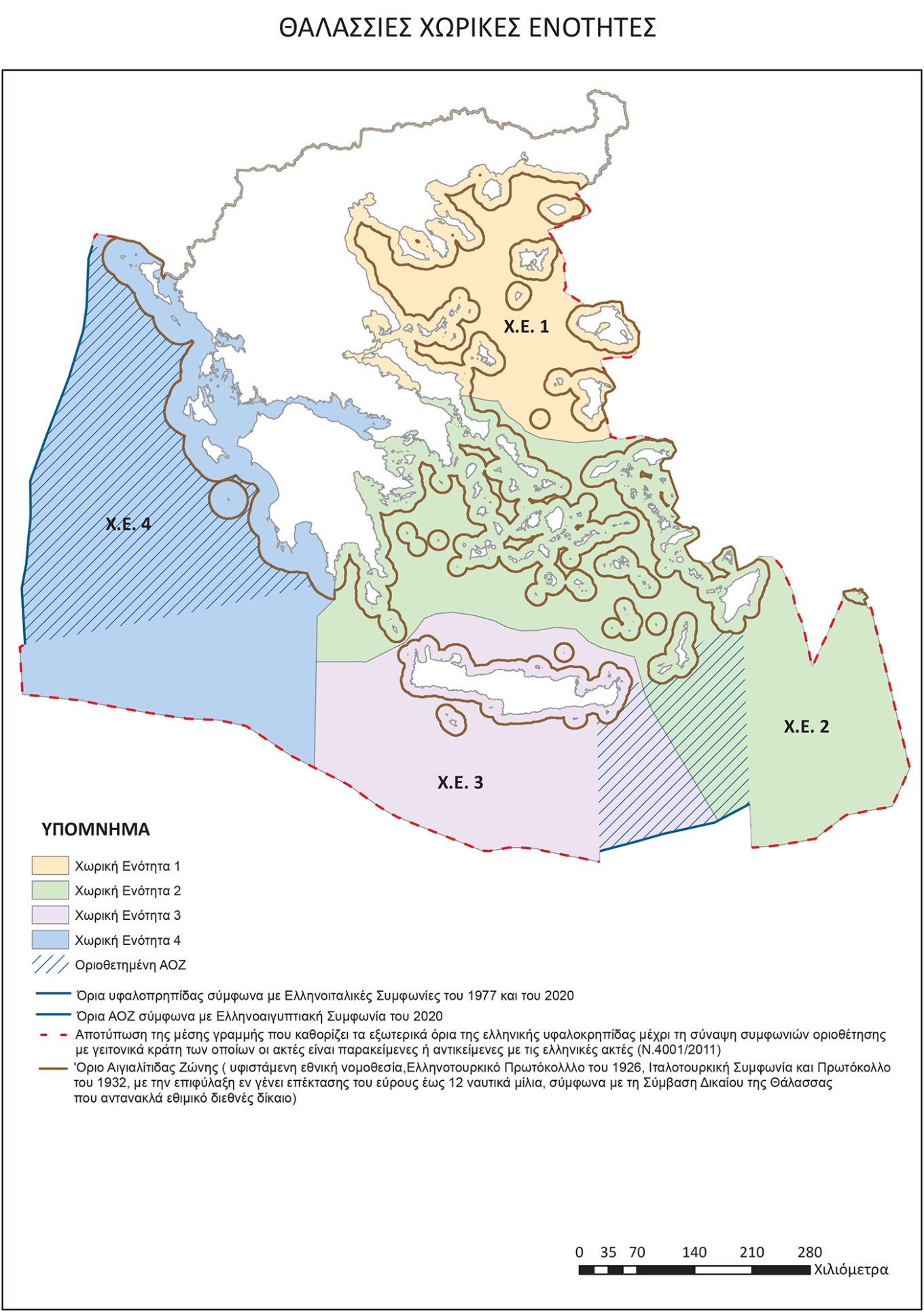
Announcement of the Marine Spatial Planning (MSP)
The MSP map shows the delimited EEZ with the two agreements with Italy and the partial delimitation agreement with Egypt, while in all other regions it shows the potential EEZ, as defined by Law 4001/2011, which sets the external boundary of the EEZ at the midline with countries where no delimitation agreement exists.
See the map
What the Marine Spatial Planning announcement means for Greece
With the approved and published map, Greece is essentially, for the first time, documenting its claims over its continental shelf/EEZ in accordance with the Law of the Sea. This constitutes the most authoritative response to Turkey’s unilateral attempt to impose faits accomplis by submitting its “external EEZ boundaries” to the UN, calculated based on the Turkey-Libya Memorandum, thereby challenging even Greece’s delimitation agreement with Egypt.
Closing
Turkey’s “nightmare,” also known as the “Seville Map,” now appears in an official Greek document published in the Government Gazette and submitted to the EU. Greece fully attributes effect to mainland coasts, all islands and islets, including Kastellorizo, thus extending its potential EEZ to the western limits of Cyprus’ EEZ.
The so-called Seville Map was created when the EU asked the University of Seville to record the continental shelves of EU member states as defined by the 1982 Law of the Sea agreement.
See the section concerning Greece’s continental shelf and EEZ:
The map also records Greece’s existing territorial waters—12 nautical miles in the Ionian and 6 nautical miles elsewhere—highlighting a “reservation of the right to extend to 12 nautical miles,” in accordance with the Law of the Sea, which, as noted, is customary international law. This underscores the compulsory nature of the Law of the Sea, even for countries like Turkey that are not parties to the Convention.
While the MSP approval is not a declaration or delimitation of the EEZ, it records the existing delimited and potential boundaries based on the Law of the Sea in remaining areas, thus cementing Greece’s positions in a European document. These now serve as the foundation for any future discussions with Turkey and Libya regarding maritime zone delimitation.
Last fall, when the European Commission first released a technical map of Greece’s MSP, Turkey reacted strongly, calling the map “unacceptable,” warning that it would not accept faits accomplis, and resurrecting the theory of “grey zones,” claiming the map showed island formations of “undefined sovereignty.”
At a particularly delicate juncture for Greek-Turkish relations, Turkey’s reaction to the MSP’s approval is especially noteworthy, especially with the upcoming visit of Kyriakos Mitsotakis to Ankara and the meeting of the High-Level Cooperation Council.
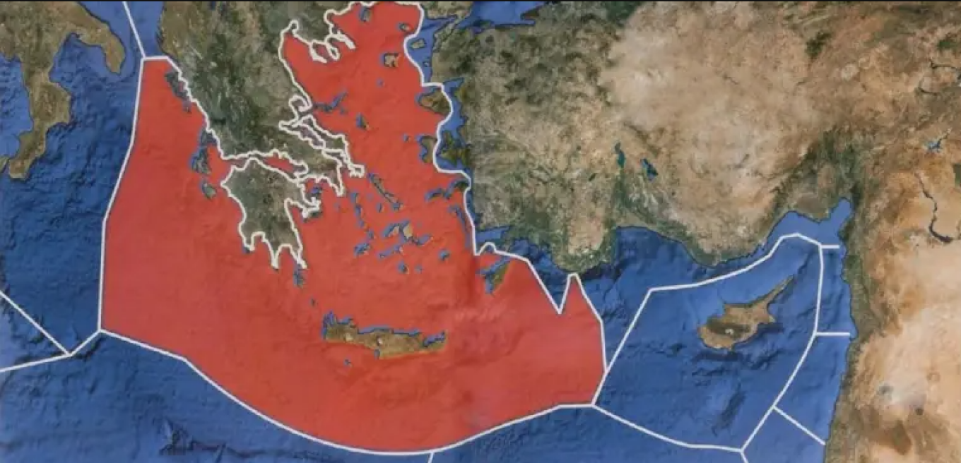
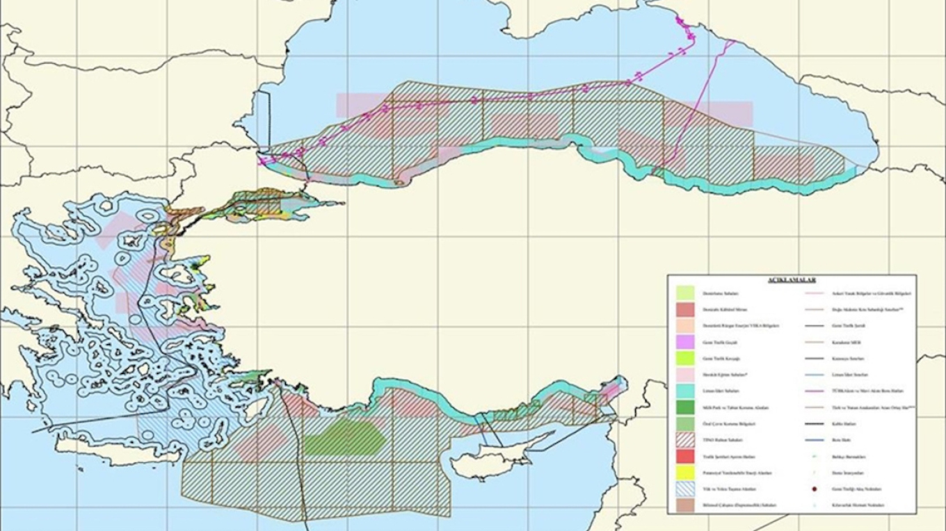
It’s no coincidence that Milliyet earlier today—before the Greek announcements—reported that Turkey was finalizing its own Marine Spatial Planning map, which, according to the paper’s sources, would adopt the “midline” approach between mainland coasts, thus completely stripping islands and islets of maritime zones. A little later, the article was updated online and the map was published.
See Turkey’s map, which splits the Aegean in two and stretches its EEZ… south of Kythera!
Statement by the Turkish Foreign Ministry
Turkey’s Ministry of Foreign Affairs issued a statement today regarding the Marine Spatial Planning map presented by Greece.
In it, the Turkish ministry called Athens’ actions “unilateral,” claiming they “violate Turkey’s maritime jurisdiction both in the Aegean and in the Eastern Mediterranean,” and stated that Ankara “will submit its own plan to UNESCO and the relevant United Nations bodies.”
The statement reads:
“Some of the areas designated in the ‘Marine Spatial Plan’ (MSP) announced by Greece under EU legislation violate Turkey’s maritime jurisdiction in both the Aegean Sea and the Eastern Mediterranean.
We reiterate that Greece’s unilateral actions and claims will have no legal effect on the Republic of Turkey.
We also remind that unilateral actions must be avoided in closed or semi-enclosed seas such as the Aegean and the Mediterranean, that international maritime law encourages cooperation between coastal states in these seas, including on environmental matters, and from this perspective, the Republic of Turkey is always ready to cooperate with Greece in the Aegean Sea.
These aforementioned actions and attempts at faits accomplis, as in the past, will have no legal effect on the Republic of Turkey today or in the future.
The Republic of Turkey remains committed to a sincere and comprehensive approach to resolving issues based on international law, equality, and good neighborly relations, in the spirit of the Athens Declaration on Friendly Relations and Good Neighborliness dated December 7, 2023, which reflects the desire of both sides to maintain this spirit in Greek-Turkish relations.
The Republic of Turkey will submit its own Plan to UNESCO and the relevant United Nations bodies.”
Statement from KYSEA
“The Government Council for National Security (KYSEA) convened today under Prime Minister Kyriakos Mitsotakis.
During the session, briefings were provided by Foreign Minister Giorgos Gerapetritis and Minister of Environment and Energy Stavros Papastavrou on the national strategy for maritime space and the preparation and detailing of the Marine Spatial Planning.
Also discussed and approved was the Long-Term Defense Equipment Programming of the Armed Forces for the period 2025–2036.”
Ask me anything
Explore related questions