The country is experiencing the first strong heatwave from Africa since yesterday, with the phenomenon peaking tomorrow, as the thermometer is expected to climb to 42°C in several regions.
However, this intense heat incursion will come to an abrupt end. By Saturday, cooler air masses will begin descending from the north, causing a noticeable temperature drop initially in eastern and northern areas.
The cooler conditions will spread across the entire country by Sunday, with temperatures dropping by as much as 10°C.
What is the Urban Heat Island phenomenon?
Meteorologist Giorgos Tsatrafilias, in a post, mentioned that warm air masses from the African coast, after crossing the western Mediterranean, will also affect our country, creating the first heatwave conditions of this summer until Friday, 27/6.
From Saturday, temperatures will begin to fall (albeit briefly), making the heat more bearable. On Thursday, Aetolia-Acarnania, Serres, Kilkis, and Thessaly will reach 41°C, while on Friday only Thessaly and Boeotia will see such highs.
“The urban heat island phenomenon will affect major urban centers…”
The urban heat island phenomenon will affect the country’s major cities over the next three days.
Urban heat island describes the phenomenon where temperatures within urban areas are higher compared to surrounding suburban or rural regions.
This phenomenon is due to human factors and began alongside urban expansion, as natural environments were gradually replaced by built structures.
Building materials like concrete and asphalt, with their high heat storage capacity and low reflectivity, absorb large amounts of solar radiation and re-emit it in cities during the day.
Dense urban construction creates “walls” that block cool air from entering and trap warm air inside.
Meanwhile, the lack of green spaces reduces natural shading and worsens the situation, as plants produce moisture through transpiration during the day that cools the surrounding environment. Additional contributing factors include human activities (such as air conditioning and vehicles) that release extra heat into the atmosphere.
🎯 Athens, Larissa, Thessaloniki, Agrinio, Sparta, and Serres are some of the cities where nighttime temperatures on Friday will exceed 30°C.
🎯 The highest temperatures (42-43°C) will occur on Friday, 27/6, in the enclosed plains of Central Macedonia and Thessaly.
🎯 From then until Sunday, temperatures will drop by 10-12°C.
Today’s weather:
Sunny overall, though during midday and afternoon, local clouds will develop mainly over mainland highlands, where scattered showers are possible. Slightly elevated dust concentrations.
Temperatures:
- Western Macedonia: 18-34°C
- Rest of Macedonia and Thrace: 20-39°C
- Thessaly: 23-40°C
- Epirus: 21-37°C
- Central Greece & Peloponnese: 19-39°C
- Ionian islands: 21-37°C
- North & East Aegean islands: 20-39°C
- Cyclades: 21-36°C
- Dodecanese: 18-35°C
- Crete: 22-35°C
Winds:
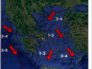
- Central & North Aegean: North 3-5 Beaufort
- South Aegean: West to northwest 3-5 Beaufort
- Ionian: Northwest 2-4 Beaufort
Athens: Sunny, north winds 2-4 Beaufort, slight dust, 27-39°C in the city center.
Thessaloniki: Sunny with scattered clouds midday-afternoon, variable winds up to 3 Beaufort, slight dust, 28-37°C in the city center.
Friday, 27 June:
Generally clear weather. During midday-afternoon, clouds will develop over mainland areas, with local showers or brief storms in the north.
Winds: North 3-5 Beaufort, locally 6 in the Aegean.
Temperature: Remaining high—40-41°C inland, 36-38°C in the Ionian, east and south island regions, 33-35°C elsewhere.
Saturday, 28 June:
Macedonia & Thrace: Variable cloudiness with some local rain, isolated storms in highlands midday-afternoon.
Elsewhere: Mostly clear, temporary clouds inland with local showers or storms in highlands.
Winds: North 4-6 Beaufort, locally 7 at sea.
Temperature: Drop of 2-3°C.
Sunday, 29 June:
Macedonia, Thrace, North Aegean islands, East Thessaly, Sporades, East Central Greece, Euboea, East & South Peloponnese: Variable cloudiness with local rain.
Elsewhere: Generally clear, with local clouds in Crete.
Winds: West 4-5 Beaufort, up to 7 in the Ionian later. East: North 4-6 Beaufort, 7-8 in the Aegean.
Temperature: Noticeable drop.
Ask me anything
Explore related questions


