Meteorologists are forecasting widespread instability, resulting in a noticeable drop in temperatures, showers, and a high frequency of lightning. Meteorologist Klearchos Marousakis has also warned of possible flooding phenomena.
In a post, the OPEN TV meteorologist referred to the change in weather from heatwave to instability and northerly winds, which will become more noticeable from Thursday onward.
“A disturbance from the region of Italy will move east-northeast, triggering instability over the central and northern parts of our country as well as the interior of the Peloponnese over the Thursday–Friday period,” he notes.
According to Marousakis, the forecast shows:
- A large volume of water locally that could lead to minor flooding episodes
- Frequent lightning
- Hailstorms with possibly large hailstones
- Sudden squalls in marine and coastal areas
- Abrupt wind strengthening during phenomena
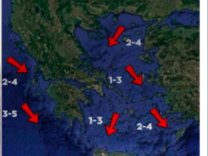
- Generalized strengthening of northerly winds up to 7 Beaufort, especially in areas facing the Aegean
Long-term trend
The gradual shift of high-pressure systems to higher latitudes will direct disturbances towards our region. This means that until around August 12–15, unstable weather will prevail, with air mass flows mainly from central Europe rather than northern Africa, preventing intense and prolonged heat waves.
Today’s Weather
Fair weather is expected with local showers in the western and northern mainland (especially mountainous areas).
Temperatures:
- Western Macedonia: 12–30/31°C
- Rest of Macedonia & Thrace: 15–35°C
- Thessaly: 15–35°C
- Epirus: 12–30/31°C
- Rest of Western Greece: 14–30/32°C
- Rest of mainland: 13–35°C
- Ionian Islands: 20–30°C
- Aegean islands & Crete: 17–30/32°C
Winds: In the Aegean and Ionian, generally northwesterly, up to 4–5 Beaufort, locally up to 6 Beaufort in the south.
Attica: Fair weather. Winds variable, up to 3–4 Beaufort, temporarily 5 Beaufort in the west in the morning. Temperatures 26–34/35°C.
Thessaloniki: Fair weather. Winds northwesterly up to 3–4 Beaufort, later shifting variable 2–3 Beaufort. Temperatures 26–34°C.
Thursday, July 31
Clouds and local showers in Macedonia, Thrace, Thessaly, Sporades, and Evia. Scattered thunderstorms initially in Macedonia, gradually spreading. Phenomena possibly locally strong, but will cease at night in western Macedonia and Thessaly.
Elsewhere, few clouds increasing by midday, with local showers and isolated storms in eastern Sterea, eastern Peloponnese, and Epirus mountains. Weather improves at night.
Winds: Northerly 4–6 Beaufort.
Temperatures: Slight further drop, with highs 31–33°C, locally 34–35°C inland.
Friday, August 1
Unsettled weather in Sporades and Evia with a few showers early morning. Gradual cloudiness inland, especially central and southern areas, with local showers or downpours. Improvement by night.
Elsewhere, generally fair.
Winds: Northerly 4–6 Beaufort, locally 7 Beaufort in the Aegean.
Temperatures: Slight drop.
Saturday, August 2
Generally fair, but inland clouds will develop midday–afternoon, possibly bringing local showers, especially in mountains.
Winds: Northerly 3–5 Beaufort, 6–7 Beaufort in eastern and southern seas.
Temperatures: No significant change.
Sunday, August 3
Generally fair. Inland clouds midday–afternoon may bring isolated showers in mountainous areas.
Winds: Northerly 3–5 Beaufort, locally 6 Beaufort in the Aegean.
Temperatures: Slight rise.
Ask me anything
Explore related questions


