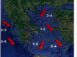
According to MEGA meteorologist Christina Rigou, winds will ease today. In fire-stricken Achaia, as well as Filippiada, winds will blow between 3 and 5 Beaufort, while in Chios, also affected by wildfires, winds will be up to 4 Beaufort. Significant wind strengthening is expected on Saturday, August 16, with stormy winds reaching up to 8 Beaufort in Lemnos, Samothraki, southern Evia, the northern Cyclades, and Attica. Winds will weaken again from Sunday, August 17 onward.
Giannopoulos: Winds to strengthen again on Saturday
As forecaster Panagiotis Giannopoulos noted, the Aegean will still have winds up to 7 Beaufort, but winds in Chios – where there is increased concern about the wildfire front – have eased. On Saturday, they will strengthen again, reaching 8 Beaufort in the Aegean, without, however, causing travel bans or significant disruption. Temperatures will also be excellent, with cooler conditions across the country. According to Giannopoulos, there are no signs of a heatwave until at least August 23.
Arnaoutoglou: Rain in Evia and northern Attica
During the Assumption Day long weekend, there is an increased likelihood of showers and local thunderstorms, mainly in mainland Greece. According to Sakis Arnaoutoglou, on August 15 there may be brief rain in Evia, and possibly northern parts of Attica.
Short showers are also possible in the southern Peloponnese and the mountainous regions of Crete. On Saturday, August 16, there is a small chance of rain in the mountains of Evia and Crete.
On Sunday (17.08.2025), instability will be more pronounced, with Evros, Rodopi, and Samothraki likely to see showers in the afternoon. Rain and short showers may also occur in Epirus, western and northern Thessaly, Aetolia-Acarnania, and possibly the Peloponnese.
Instability will peak on Monday, August 18, with rain expected across much of mainland Greece – from western and central Macedonia to the Peloponnese.
Possible showers expected in:
- Western Macedonia
- Epirus
- Thessaly
- Central Greece
- Northwestern Attica
- Ionian Islands
Similar conditions are forecast for Tuesday, August 19. Between August 22 and 25, temperatures will rise slightly but without extreme heat, and generally mild weather will continue, with occasional showers in some regions.
Χάρτης Πρόβλεψης Κινδύνου 🔥για αύριο Παρασκευή 15/08
— Civil Protection GR (@CivPro_GR) August 14, 2025
🟠 Πολύ υψηλός κίνδυνος 4️⃣ σε:
📍#Αττική #Βοιωτία #Εύβοια #Αργολίδα #Κορινθία & περιοχές #Φθιώτιδας
📍#Έβρο #Ροδόπη #Ξάνθη #Καβάλα #Χαλκιδική & #Άγιον_Όρος
📍Π.Ε. #Ρόδου #Κάρπαθο #Κάσο #Θάσο #Σαμοθράκη #Σποράδες #Σκύρο… pic.twitter.com/MK7ZEpyNGb
“Orange” fire alert in 8 regions
A very high fire risk (Category 4) is forecast for today, Friday, August 15, 2025, in much of the country, according to the Fire Risk Prediction Map from the General Secretariat for Civil Protection.
Regions at high risk include:
- Attica
- Peloponnese (Corinthia, Argolis)
- Central Greece (Fthiotida, Viotia, Evia incl. Skyros)
- Thessaly (Sporades)
- Central Macedonia (Halkidiki)
- Eastern Macedonia and Thrace (Kavala, Thasos, Xanthi, Rodopi, Evros incl. Samothraki)
- North Aegean
- South Aegean (Rhodes, Karpathos)
Authorities remain on high alert, with preventive bans on vehicle traffic and camping in national parks, forests, and vulnerable areas. Citizens are urged to avoid outdoor activities that could spark a fire, such as burning dry grass, using spark-producing machinery, or outdoor grilling.
Today’s forecast
Clouds alternating with sunshine, with possible brief showers, mainly in mountainous areas.
Temperatures:
- Western Macedonia: 17–30°C
- Rest of Macedonia & Thrace: 19–35°C
- Thessaly: 20–34°C
- Epirus: 19–33°C
- Western Central Greece: 22–36°C
- Rest of Central Greece & Peloponnese: 19–34°C
- Ionian Islands: 20–33°C
- North & East Aegean: 20–34°C
- Cyclades & Dodecanese: 21–30°C
- Crete: 19–31°C
Winds:
- Central & Northern Aegean: N–NE, 4–6 Beaufort
- Southern Aegean: W–NW, 3–5 Beaufort
- Ionian: variable, 2–4 Beaufort
Saturday, August 16: Mostly clear, some clouds in the north, with possible showers in the NW mountains. Winds N, 3–7 Beaufort. Highs: 30–36°C.
Sunday, August 17: Cloudier in the northwest, with afternoon showers in some mainland areas. Winds NW, 3–6 Beaufort. Little temperature change.
Ask me anything
Explore related questions


