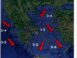
A barometric low forming in southern Italy on Wednesday afternoon (1/10) is expected to move towards the Ionian Sea, causing intense weather in many parts of Greece from Thursday.
According to Thodoros Kolydas, starting Thursday morning, bad weather will begin to affect the Ionian Islands and western mainland areas as the system moves further east. The most intense phenomena are expected after noon, he stresses.
The meteorologist draws attention not only to western Greece, but also to the northern parts of the country on Thursday, while on Friday the phenomena will extend to the eastern Aegean and the Dodecanese.
The weather on Wednesday, according to the National Weather Service:
In Thrace, the Cyclades, the islands of the eastern Aegean and the Dodecanese a few clouds. In the west, a few clouds that will gradually increase from the afternoon and there will be local rainfall that will intensify from the night in the Ionian Sea and sporadic thunderstorms will occur.
They will increase in intensity and may be accompanied by thunderstorms and thunderstorms.
In the rest of the country cloudy with local rain and in the eastern Peloponnese and central Macedonia isolated thunderstorms. Winds will be in the west variable 3 to 4 and from the evening in the Ionian Sea southeastern 5 Beaufort. In the east will blow from the north 3 to 4, in the eastern Aegean 4 to 5 and locally in the Dodecanese up to 6 Beaufort.
The temperature in the northwestern mainland will not exceed 19 to 20 degrees Celsius, while in other areas it will reach 23 to 25 degrees Celsius and in Crete and the Dodecanese locally 26 degrees Celsius.
Ask me anything
Explore related questions


