
The skies have opened up across many areas of Attica, with localized rain and thunderstorms. This weather instability is expected to last until Wednesday, October 8, already affecting several regions across the country.
By late Monday afternoon, torrential rain was reported in Haidari, Petroupoli, SKA, Zephyri, Peristeri, Ano Liosia, Kamatero, and Aspropyrgos. Rainfall was also recorded in the northern suburbs of Attica.
Heavy rains are occurring in areas of the Peloponnese, Evia, Chania, Samos, Chios, and Skiathos.
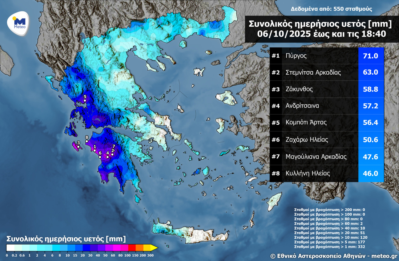
By the afternoon, the highest rainfall amounts had been recorded in Western Greece and the Peloponnese. According to Meteo, the Ionian Islands, western mainland Greece, and the Peloponnese were the regions most affected by the storm system until Monday afternoon. The accompanying image map shows the distribution of accumulated rainfall up to 18:40, according to the network of automatic weather stations operated by the National Observatory of Athens, along with the 8 stations that recorded the highest rainfall. The highest amount of rain recorded nationwide was in Pyrgos, Ilia, with 71 millimeters.
Rain Forecast for Tuesday
The low-pressure system that formed over the Adriatic has moved eastward, already affecting much of the country. The main characteristics of the storm system are:
- Heavy localized rain and thunderstorms continuing until Tuesday noon, October 7
- Strengthening winds, reaching 6–7 Beaufort in the seas on both Monday (October 6) and Tuesday (October 7)
- A drop in temperature on Tuesday compared to Monday
Temperatures will remain below seasonal averages. In the north, highs will not exceed 20–21°C, while in the rest of the country they will range between 22–25°C.
On Tuesday, the low-pressure system will remain over the northern Aegean, bringing intense rain and storms to Thrace, the Eastern Aegean islands, and the Dodecanese. The rest of the country will experience unstable conditions, with scattered showers and storms, mainly in the west. Winds will blow from the west-northwest at 6–7 Beaufort, locally reaching 8 in the Ionian. Temperatures will continue to fall, with highs of 15–18°C in the north and up to 22–24°C in the south.
Wednesday’s Weather
The low-pressure system will begin moving eastward, but rain will persist in the Aegean and eastern mainland. The rest of the country will see gradual improvement, with winds from the west-northwest up to 7 Beaufort and no significant temperature change.
From Thursday and Friday onward, the weather is expected to improve significantly, with weaker winds, rising temperatures, and the return of sunshine — promising a pleasant and mild autumn weekend.
Ask me anything
Explore related questions