The severe weather system “Adel,” which hit Attica yesterday with intense weather conditions, appears to be easing today. Early indications suggest that the phenomena are now limited to the islands of the Eastern Aegean and the Dodecanese. In Attica, rainfall will be milder, and winds have weakened.
Despite the gradual improvement, meteorologists warn of local showers and thunderstorms continuing in the Eastern Aegean, although Saturday is expected to be milder compared to previous hours, and by Sunday the weather will improve throughout Greece.
According to the emergency weather bulletin from the Hellenic National Meteorological Service (EMY), the system named ADEL will be confined to the eastern Aegean on Saturday (29-11-25).
Strong rains and thunderstorms are forecasted:
a. In the Eastern Aegean islands until midday
b. In the Dodecanese until late afternoon
Problems in Attica from severe weather “Adel”
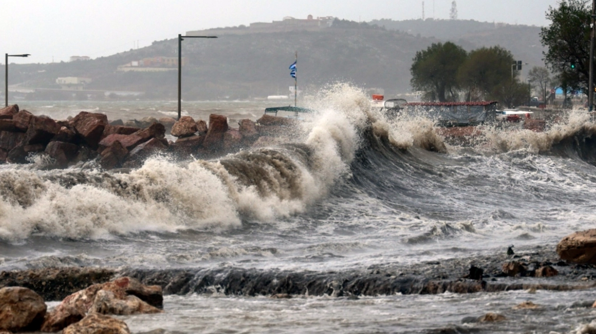
On Friday, the storm system Adel caused major disruptions across Attica. From early morning, Athens faced extreme weather—torrential rain, thunderstorms, and strong winds. Many streets flooded, causing major traffic issues.
Kifisos Avenue and other central roads were flooded, causing congestion and delays. Emergency services received numerous calls for water pumping and flood-related incidents. Schools and public services in many areas remained closed due to hazardous conditions.
A sudden storm also erupted just before midnight, accompanied by strong winds and hail.
Within just ten minutes, the sudden downpour caused serious problems in several areas of Attica, including Halandri, Agia Paraskevi, and Keratsini, with reports of intense and unusually large hailstones.
Similar conditions were recorded in Aspropyrgos, Piraeus, and even central Athens, with strong winds and heavy rain.
Strong wind gusts caused a large tree to fall onto four cars on Piraeus Street, causing material damage.
Civil Protection continues to monitor the situation, while restoration of Friday’s flood damages has already begun.
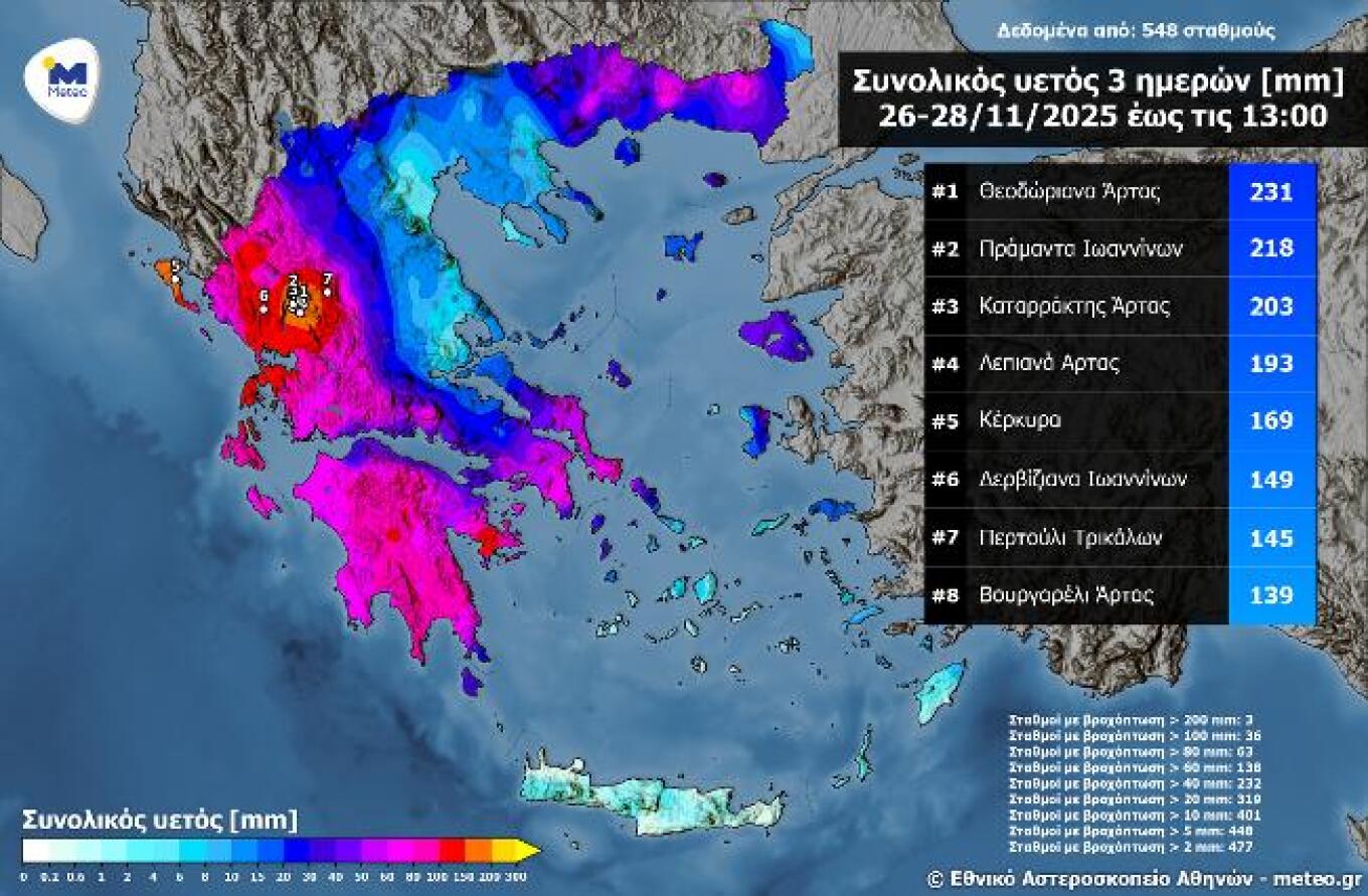
Very high cumulative rainfall over three days – Rainfall in Tzoumerka exceeds 200 mm
Persistent and locally intense rainfall affected almost all of Greece in successive waves. The rains began on Wednesday 26/11 in western Greece, the Peloponnese, and eastern Macedonia & Thrace, and continued until today, Friday 28/11, with significant rainfall recorded also in eastern regions, including Athens. As a result, very high cumulative rainfall totals have been noted.
According to the meteo.gr / National Observatory of Athens network, rainfall exceeded:
• 100 mm at 36 stations
• 80 mm at 63 stations
• 60 mm at 138 stations
Additionally, three stations in Epirus—specifically in Tzoumerka—recorded over 200 mm, further burdening an already difficult situation, as total November rainfall has now exceeded 900–1000 mm in the area.
Today’s weather
Strong rains and thunderstorms are expected in Central and Eastern Macedonia, Thrace, and the northern Aegean islands, with improvement after midday. Storms with hail are expected in the Cyclades and especially the Eastern Aegean islands and the Dodecanese, with temporary improvement before midday. Elsewhere, unsettled weather with scattered showers and isolated thunderstorms will prevail. More intense phenomena will occur in the Ionian Islands, western mainland, and Crete. Light snow may fall on mountainous mainland areas. Visibility will be limited in the early morning and evening, especially inland.
Temperatures:
• Western Macedonia: 2–9°C
• Other Macedonia & Thrace: 5–12/14°C
• Thessaly: 5–14/16°C
• Epirus: 6–14°C
• Other mainland: 9–14/17°C
• Ionian Islands: 11–15/16°C
• Northern & Eastern Aegean: 10–15/17°C
• Other Aegean islands & Crete: 12–17/19°C
Winds:
• Aegean: southerly up to 6 Beaufort, turning west-northwest up to 6–7 Beaufort
• Ionian: northwest up to 5 Beaufort
Athens: Cloudy with occasional showers and possible brief thunderstorms. Winds westerly up to 4 Beaufort, later shifting west-northwest up to 5–6 Beaufort. Temperature 11–16/17°C.
Thessaloniki: Cloudy with occasional showers. Winds northwest up to 4 Beaufort. Temperature 8–14°C.
Sunday, November 30 weather
In the eastern Aegean, clouds with local showers and isolated thunderstorms until afternoon. Elsewhere, few clouds, locally increased in western and southern regions with light local rain. Visibility will be locally limited in the morning and evening inland.
Winds will blow west-northwest at 3–4 Beaufort, and locally 5–6 Beaufort in the south.
Temperatures will remain stable:
• Northern mainland: 13–15°C
• Western & central mainland: 16–18°C
• Southeastern mainland: up to 19°C
• Eastern & southern island regions: 18–20°C
Ask me anything
Explore related questions