
The Hellenic National Meteorological Service (EMY) issued an emergency weather bulletin at midday on Wednesday, including a red warning.
According to the bulletin:
Heavy rain and thunderstorms are expected from Thursday, December 4, 2025, until the morning of Saturday, December 6, 2025, in most areas of the eastern and southern parts of the country.
It is noted that the rainfall will not only be intense but also long-lasting. In many areas, the severe weather will be accompanied by local hail and at times by very strong winds, which on Friday, December 5, 2025, in the southeastern islands may reach force 8 and occasionally force 9 Beaufort.
Specific areas affected
Thursday, December 4, 2025: Heavy rain and thunderstorms in:
- Ionian Islands
- Central Macedonia (mainly Chalkidiki, Pieria, Imathia)
- Thessaly (mainly eastern parts)
- Eastern Central Greece (including Attica, mainly southern and eastern parts)
- Euboea (mainly southern parts)
- Peloponnese (mainly southern and eastern parts)
- Cyclades
- Crete (mainly southern parts)
- Eastern Aegean islands (from Chios southwards) and Dodecanese
Friday, December 5, 2025: Heavy rain and thunderstorms in:
- Central Macedonia
- Thessaly and the Sporades
- Eastern Central Greece (including Attica) and Euboea
- Eastern and southern Peloponnese
- Cyclades and Crete
- Eastern Aegean islands (from Chios southwards) and Dodecanese
Red alert areas (particularly severe and potentially dangerous) include: Pieria, Imathia, Chalkidiki, Thessaloniki, Thessaly, Sporades, Euboea, Eastern Aegean islands, and Dodecanese.
Saturday, December 6, 2025: From the morning, severe weather is expected to weaken in most areas and be confined mainly to the Dodecanese.
Severe Weather: High Rainfall Expected in Thessaly, Pieria, Olympus, and Western Chalkidiki – New Maps from Thodoris Kolydas
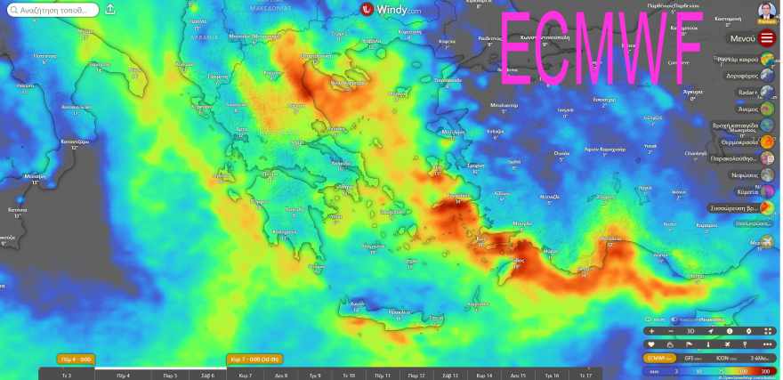
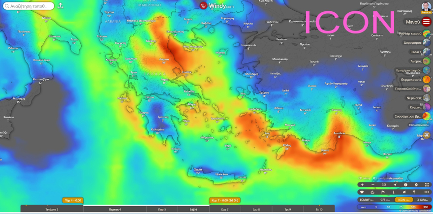
The two leading European forecast models, ECMWF and ICON, show remarkable agreement regarding the distribution and intensity of rainfall over the next three days, warning of widespread and persistent severe weather across Greece. Meteorologist Thodoris Kolydas confirms this assessment, highlighting particular areas that will be especially affected due to orographic effects.
In his post, he notes:
*”Since yesterday, we have reported that the two European models – ECMWF and ICON – show remarkable convergence in the distribution and intensity of rainfall for the next three days. Both simulations agree that Greece is entering a period of widespread, persistent, and locally intense rainfall, focusing on specific regions.
The GFS model, on the other hand, remains more ‘conservative,’ showing rain but significantly underestimating quantities. It is not uncommon for GFS to underperform with Mediterranean systems, especially when they are strengthened by the sea and interact with topography – something we know well in our country.”*
Cumulative Rainfall Forecast through Saturday
- Thessaly, Pieria, Olympus, and Western Chalkidiki:
The orography acts as a “multiplier” for rainfall, with both ECMWF and ICON predicting the highest precipitation totals in the country. - Eastern Central Greece – Euboea:
Mainly the windward areas under south–southeast winds will be affected. - Southeastern Aegean – Kos, Rhodes, Karpathos:
Strong agreement between models, both showing widespread rainfall. - Ionian & Western Mainland:
Rainfall will not reach the levels of the eastern regions, but ECMWF and ICON agree that western areas, particularly Epirus, Aetolia-Acarnania, and Achaia, will receive significant precipitation. - Crete (mainly southeast):
Conclusion
- When ECMWF and ICON agree on such a large scale and with such consistency, the probability of verification increases significantly. Greece is heading into a three-day period of widespread rainfall affecting Thessaly, Pieria, Chalkidiki, Eastern Central Greece, Euboea, and the Southeastern Aegean (Kos, Rhodes).
- Forecasts and warnings from HNMS are awaited, which since yesterday have already indicated the possibility of strong phenomena.

Ask me anything
Explore related questions