Six Regional Units of the country are being placed today, Monday January 26, under a “Red Code” state of mobilization due to worsening weather conditions and an increased risk of flooding.
These include the Regional Unit of Serres in Central Macedonia, as well as the Regional Units of Drama, Kavala, Thasos, Xanthi, and Rodopi in the Region of Eastern Macedonia and Thrace.
Severe weather has also caused disruptions to ferry services, as the morning routes of Blue Star Delos and Fast Ferries Andros were canceled, while flying dolphins to the islands of the Saronic Gulf are also docked. In addition, the morning departure from the port of Rafina will not take place.
Civil Protection decision following an Emergency Weather Deterioration Bulletin by the EMY
According to an announcement by the Ministry of Climate Crisis and Civil Protection, the General Secretariat for Civil Protection placed the above areas under “Red Code” status following the issuance of an Emergency Weather Deterioration Bulletin by the Hellenic National Meteorological Service (HNMS) and a meeting of the Risk Assessment Committee.
In this context, municipalities and regions are called upon to immediately convene the Local and Regional Civil Protection Operational Coordination Bodies (T.E.S.O.P.P. and P.E.S.O.P.P.) in order to assess the readiness of mechanisms and measures to address potential flooding phenomena.
Category 3 rainfall event – Locally intense phenomena
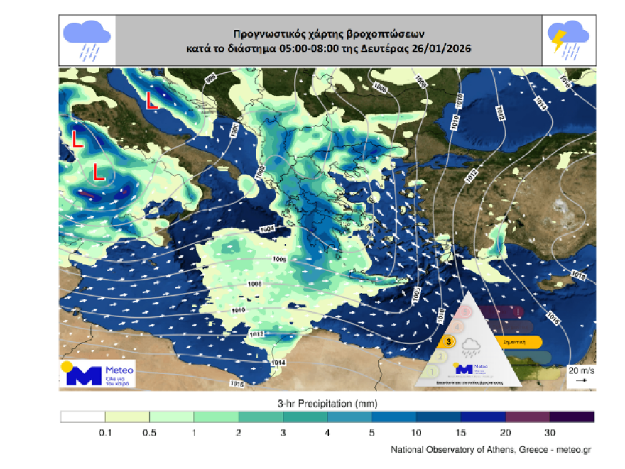
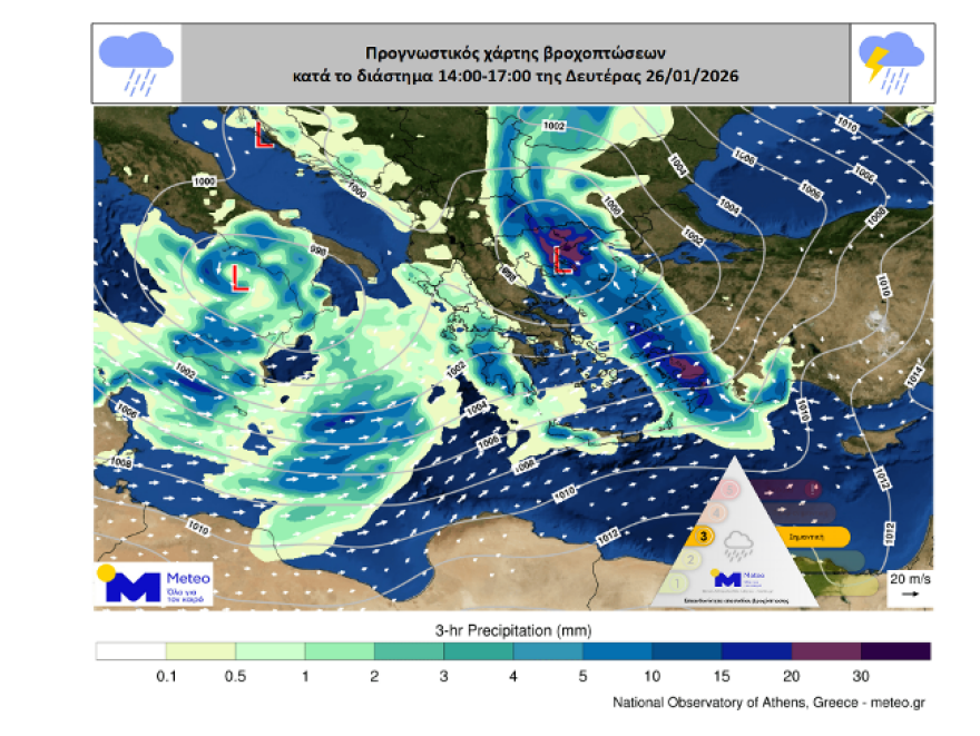
According to the available forecast data from the National Observatory of Athens / Meteo.gr, on Monday 26/01 a Category 3 (Significant) rainfall event is expected, with locally heavy rain and thunderstorms.
The deterioration of the weather will begin in the west and gradually expand to:
- Eastern Central Greece,
- Southern and Eastern Peloponnese,
- Evia,
- Central and Eastern Central Greece,
- Crete from the pre-noon hours,
- Cyclades from midday,
- Sporades,
- the islands of the Northern and Eastern Aegean,
- and the Dodecanese.
The phenomena will locally be accompanied by hailstorms, mainly in island areas of the Southern and Eastern Aegean, and possibly in parts of northeastern Peloponnese and southern Attica. At the same time, locally gale-force southerly winds will prevail in the Aegean.
The following maps show the estimated rainfall totals at two time snapshots on Monday 26/01.
Kallianos: “Not alarmism, but heightened alertness in Attica”
In a social media post, meteorologist Giannis Kallianos notes that from midnight until the early morning hours of Monday, weather conditions in Attica will gradually become unstable, with light local rainfall, and no serious problems expected.
However, between 07:00 and 10:00–11:00 in the morning, thunderstorms are expected to pass through the prefecture, which could locally produce increased rainfall totals. He stresses, however, that these phenomena are in no way comparable to last week’s destructive storm in Ano Glyfada.
Special attention to Ano Glyfada, Hymettus, and the Southern Suburbs
Particular reference is made to Ano Glyfada and the Southern Suburbs in general, where debris remains on roads despite cleanup efforts. As Mr. Kallianos notes, even brief but intense rainfall can cause the movement of mud, stones, and soil.
Increased caution is advised:
- on roads with remaining debris,
- in areas near slopes and streams,
- in the wider Hymettus area, where excavation works have reduced the soil’s natural absorbency,
- on downhill roads in the Southern Suburbs,
- and in keeping drains and runoff systems clear.
“No alarmism – Yes to timely prevention”
As the meteorologist emphasizes, this is not an extreme or dangerous phenomenon comparable to the recent flooding event. However, the burden on soil and infrastructure necessitates heightened preparedness.
“Proper management of natural disasters is based on the timely identification of vulnerable points and not on alarmism,” he notes, calling on both citizens and authorities to remain on heightened alert over the coming hours.
EMY Emergency Weather Deterioration Bulletin
“Orange” warning
Heavy rain and thunderstorms are forecast today, Monday (26-01-2026), in many parts of the country.
Gale-force southerly winds will blow in the Aegean.
More specifically, heavy rain and thunderstorms will occur on Monday (26-01-2026):
a. in western Greece until midday
b. in eastern Macedonia from the morning hours and from the pre-noon hours in central Macedonia, and temporarily in Thrace
c. in the islands of the Eastern Aegean and the Dodecanese from early afternoon
d. in Crete (mainly western and southern parts) from the pre-noon hours
e. in Attica from the morning until midday hours
Today’s weather
Rain and thunderstorms, locally intense, are forecast in western, northern, and eastern mainland areas, Evia, the Cyclades, the islands of the Eastern Aegean, and the Dodecanese. Snowfall will occur in mountainous areas of western and northern Greece.
Temperatures will range from 3 to 10°C in Western Macedonia; 10 to 14–15°C in the rest of Macedonia and Thrace; 11 to 17°C in Epirus; 7 to 14°C in Thessaly; 11 to 14°C in Central Greece; 6 to 14°C in the Peloponnese; 10 to 17°C in the Ionian Islands; 12 to 15°C in the Northern Aegean islands; 12 to 14–15°C in the remaining Aegean islands; and 14 to 17°C in Crete.
Winds will blow from westerly to southwesterly directions, and in the east from southeasterly gradually turning southwesterly, at 4–6 Beaufort, locally 7 and temporarily up to 8 Beaufort in the Eastern Aegean until midday.
In Attica, increased cloudiness with rain and thunderstorms is forecast. Winds will be southwesterly gradually turning southeasterly at 3–5 Beaufort. Temperatures will range from 9 to 15°C.
In Thessaloniki, rain and thunderstorms will occur. Winds will be variable at 2–4 Beaufort, and up to 5 Beaufort in the Thermaic Gulf. Temperatures will range from 9 to 15°C.
Weather on Tuesday 27-01-2026
Unstable weather with rain and scattered thunderstorms is forecast in the islands of the Eastern Aegean, the Dodecanese, the Cyclades, and Crete, and temporarily until midday–afternoon in the Ionian, Macedonia, and Thrace. Gradual improvement across the country from the afternoon and from the west, except in eastern and southern island regions where phenomena will persist. Light snowfall will occur in the mountainous areas of northern mainland Greece. Meteorological conditions favor the transport of African dust to southern and eastern regions.
Winds will blow southerly to southwesterly at 4–6 Beaufort, locally 7 Beaufort in the east and south. Elsewhere, northerly to northwesterly winds will prevail at 4–5 Beaufort, gradually reaching 6 Beaufort in the Ionian.
Temperatures will drop slightly, reaching 14–16°C in the Ionian and mainland areas, not exceeding 12–13°C in the northwest, and reaching 17–18°C elsewhere.
Weather on Wednesday 28-01-2026
In the islands of the Eastern Aegean and the Dodecanese, cloudiness with local rain and isolated thunderstorms (mainly in the Dodecanese), gradually weakening. In the rest of the country, few clouds increasing gradually in the west, with local rain after midday.
Winds will blow from southern directions in the west at 4–6 Beaufort, and westerly to southwesterly at 4–5 Beaufort in the east.
Temperatures will rise slightly in the west.
Weather on Thursday 29-01-2026
Locally increased cloudiness with rain and scattered thunderstorms is forecast initially in the west, quickly spreading to the rest of the country. In the evening, phenomena will weaken and be confined mainly to eastern areas. Snowfall will occur in mountainous regions of western and northern Greece.
Winds will be southerly to southwesterly at 4–6 Beaufort, reaching 7 and possibly temporarily up to 8 Beaufort in the Aegean.
Temperatures will rise slightly in the south.
Weather on Friday 30-01-2026
Locally increased cloudiness with rain and scattered thunderstorms in eastern and southern island regions. Elsewhere, intervals of cloudiness with a few local showers in the west.
Winds will blow from westerly directions at 3–4 Beaufort, and only in southern seas at 4–5, locally 6 Beaufort.
Temperatures will show no significant change.
Ask me anything
Explore related questions