Today’s weather will be changeable, with cloud cover and local rain affecting the islands of the Eastern Aegean and the Dodecanese, while isolated thunderstorms are also expected in the Dodecanese, which will quickly subside.
In the rest of the country, the day will start with limited cloud cover, which will increase from midday onwards, bringing local rain, while from the afternoon scattered thunderstorms will develop in the western regions. Snowfall is expected in the mountainous areas of Epirus and Western Macedonia from the evening. Winds will initially be westerly to northwesterly at 4–5 Beaufort, locally up to 6 Beaufort in the south, later turning southerly to southwesterly, reaching locally 7 Beaufort in the Aegean. Temperatures will rise slightly, reaching 15–17°C in the Ionian and mainland areas, while in the northwest they will remain at 12–13°C and in the rest of the islands they will reach 18–19°C.
However, a deterioration of the weather is expected from Wednesday evening. According to the forecast by Giannis Kallianos, during Thursday the weather will worsen further, with rain and thunderstorms across most parts of the country.
As the meteorologist notes, although rainfall will occur across almost the entire country—more widespread and intense in some areas and more local and weak in others—special attention is required in the areas within the highlighted zone, where thunderstorms will also develop at times and may locally be intense.
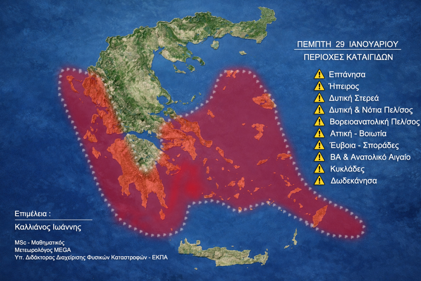
“I would like to stress that this is a typical winter weather system for January and does not constitute an extreme or unprecedented phenomenon. However, increased readiness is required because there are already areas affected by previous rainfall, as well as regions where high rainfall rates may occur,” he notes.
Why increased caution is required in already burdened areas:
Saturated soils:
Previous rainfall has significantly reduced the soil’s absorption capacity, increasing the risk of surface runoff and local flooding, even with moderate rainfall.
Hydrological fatigue of drainage basins:
Streams, torrents and small waterways now respond faster and more abruptly, with smaller amounts of rainfall sufficient to cause overflows.
Stressed infrastructure:
Road networks, drainage systems and slopes are already under strain, especially in southern parts of Attica, increasing the likelihood of landslides or local accessibility problems.
What to watch out for:
Targeted monitoring in already affected areas, rather than a blanket approach nationwide.
Timely information and operational readiness of local authorities, especially in flood-prone areas.
Avoid complacency, as phenomena may be locally intense even if they are generally considered seasonal.
Finally, during the weekend, weather conditions will once again become unstable across most of the country, with showers, rain and locally thunderstorms.
In summary, these are not extreme events, but weather systems that require increased preparedness, mainly due to existing vulnerabilities. Particular attention should be paid to areas within the highlighted zone (Thursday map), where phenomena may suddenly intensify at a local level.
Today’s weather, Wednesday 28 January
MACEDONIA, THRACE
Weather: Few clouds increasing gradually, with local rain from the afternoon and possibly isolated thunderstorms at night in the west. Snowfall is expected in the mountainous areas of Western Macedonia from the evening.
Winds: Variable 3–4 Beaufort, turning southwesterly 4–6 Beaufort from midday.
Temperature: 2 to 15°C, 3–4°C lower in Western Macedonia.
IONIAN ISLANDS, EPIRUS, WESTERN CENTRAL GREECE, WESTERN PELOPONNESE
Weather: Increased cloud cover with local rain from the late morning hours. Scattered thunderstorms in the north from the afternoon. Snowfall in the mountains of Epirus from the evening.
Winds: Westerly 3–5 Beaufort, quickly turning southerly 5–6 Beaufort.
Temperature: 7 to 17°C, and in inland Epirus from -2 to 12°C.
THESSALY, EASTERN CENTRAL GREECE, EUBOEA, EASTERN PELOPONNESE
Weather: Few clouds increasing in the afternoon. Chance of local rain in Thessaly and eastern Peloponnese.
Winds: Westerly 3–5 Beaufort, turning southwesterly 4–6 Beaufort from midday.
Temperature: 2 to 17°C, 2–3°C lower in the north.
CYCLADES, CRETE
Weather: Few clouds increasing in the afternoon.
Winds: Westerly to northwesterly 4–6 Beaufort, turning southwesterly 5–7 Beaufort from midday.
Temperature: 11 to 18°C, locally up to 19°C in Crete.
EASTERN AEGEAN ISLANDS – DODECANESE
Weather: Cloudy with local rain and isolated thunderstorms in the Dodecanese, improving quickly.
Winds: Westerly to northwesterly 4–5 Beaufort, turning southwesterly 5–7 Beaufort in the afternoon.
Temperature: 10 to 18°C, locally up to 19°C in the Dodecanese.
ATTICA
Weather: Few clouds increasing in the afternoon.
Winds: Westerly to northwesterly 3–4 Beaufort, turning southwesterly 4–5 Beaufort in the afternoon, strengthening slightly at night.
Temperature: 7 to 16°C.
THESSALONIKI
Weather: Few clouds increasing rapidly, with local rain from the afternoon.
Winds: Variable 3–4 Beaufort, turning southeasterly later.
Temperature: 6 to 15°C.
Forecast for Thursday 29 January 2026
In the Ionian, Epirus, Western Central Greece, Western Peloponnese and gradually in Thrace and the Eastern Aegean islands, increased cloud cover with rain and scattered thunderstorms, possibly locally intense. From late morning, rain will spread to the rest of the country, while thunderstorms will mainly affect southern mainland areas and the Cyclades. Phenomena in the west will weaken in the evening.
Snowfall is expected in the mountainous areas of central and northern Greece.
Winds: Southerly to southwesterly 4–6 Beaufort, 7 Beaufort over the seas and locally up to 8 Beaufort. Gradual weakening in the north from the evening.
Temperature: Up to 15–16°C in the Ionian and mainland, 17–19°C in the islands, but no more than 10–12°C in northern mainland areas.
Forecast for Friday 30 January 2026
Cloudy with local rain in the west and northeast. Rain and scattered thunderstorms in the eastern islands, possibly locally strong in the Dodecanese until early morning. Elsewhere, intermittent cloud cover increasing in the south after midday, with rain in Crete and the southern Aegean intensifying overnight.
Conditions favor the transport of African dust, mainly in the south.
Winds: Westerly 4–5 Beaufort, 6 Beaufort over the seas, locally up to 7 Beaufort in the south.
Temperature: No significant change.
Forecast for Saturday 31 January 2026 & Sunday 1 February 2026
Cloudy with rain and scattered thunderstorms in western, central and southern areas, possibly locally strong. Elsewhere, periods of increased cloud cover with local rain.
Snowfall in mountainous mainland areas.
Winds: In the south, westerly to southwesterly 4–6 Beaufort, locally 7 Beaufort over the seas; in the north, northeasterly with similar intensity.
Temperature: Gradual drop in central and northern regions.
Ask me anything
Explore related questions