Scientists exploring the deep waters around Britain’s Caribbean territories for the first time have revealed an impressive series of discoveries, including an underwater mountain range, a massive “blue hole,” healthy coral reefs and marine creatures never previously recorded.
The mission took place in waters surrounding the Cayman Islands, Anguilla, and Turks and Caicos Islands. For six weeks researchers worked continuously, around the clock, using cameras and specialized equipment able to withstand the enormous water pressure at depths reaching 6,000 meters.
The research was carried out by the British research vessel RRS James Cook, led by James Bell and scientists from the three islands. The first footage and findings were shared with the BBC by the Centre for Environment, Fisheries and Aquaculture Science (CEFAS).
A nearly unknown underwater world
Despite the fact that these areas host a large share of the biodiversity found in Britain’s overseas territories, scientists had previously been forced to rely on decades-old maps containing major inaccuracies and gaps.
According to Dr. Bell, the mission marked “the first step into environments humans have never seen before—and in some cases did not even know existed.”
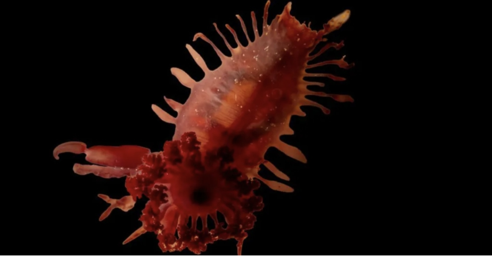
Just one day before making the statement, the team discovered an unknown species of swimming sea cucumber, which scientists have not yet been able to identify.
Thousands of organisms and new species
In total, researchers recorded nearly 14,000 organisms and 290 different marine species, although further scientific analysis is required to confirm some of the findings.
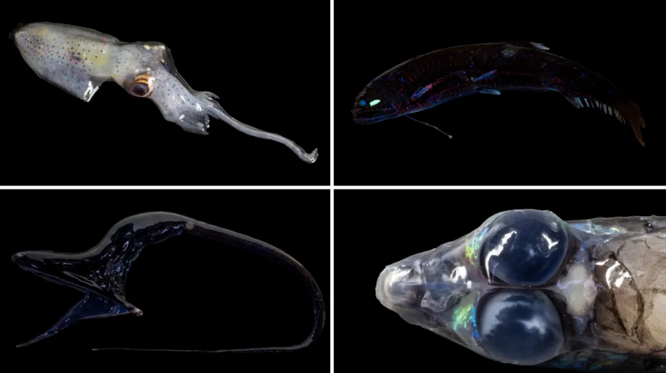
Among the organisms identified were:
- a pelican eel with a glowing pink tail that flashes red to attract prey
- a barreleye fish with tubular eyes that look upward to detect the shadow of its prey
- a dragonfish with a luminous projection beneath its chin
The cameras also captured glowing lanternfish and cephalopods whose appearance researchers described as “alien-like.”
An underwater mountain full of life
One of the most important discoveries of the mission was an unknown seamount north of Little Cayman, known as Pickle Bank.
Its peak rises from a depth of about 2,500 meters and reaches just 20 meters below the sea surface.
Images show a spectacular slope in vivid blue, yellow and orange colors, teeming with life. Corals grow there in tower-like structures, while others resemble large “brain-shaped” formations.
Researchers recorded fish moving among gorgonian corals, along with orange jelly-like sponges growing beside black corals.
The reef is considered one of the healthiest in the region, as it appears to have avoided the coral disease that has affected much of the Caribbean.
Deep reefs resisting climate change
The so-called mesophotic reefs—reefs located at greater depths—are often protected from the rising ocean temperatures associated with Climate Change.
Since 2023, increased ocean temperatures have destroyed around 80% of corals worldwide, yet these deeper reefs remain in better condition because of their depth.
Underwater mountain range and giant “blue hole”
The expedition also identified a 3,200-meter-high underwater mountain range stretching for about 70 kilometers along the seabed west of the Gentry Bank area in the Turks and Caicos Islands.
Additionally, 75 kilometers south of Grand Turk, scientists discovered a huge blue hole—a vertical submerged cave formed when the roof of an underground cavern collapsed.
The hole measures about 300 meters in width and reaches 550 meters below the sea surface. According to researchers, it may be one of the deepest in the Caribbean, comparable to the famous Great Blue Hole in Belize.
Although such areas are usually almost devoid of life, cameras recorded small sponges, a species of sea urchin and several types of fish.
Corals thousands of years old
North of Anguilla, scientists also confirmed the existence of a reef about four kilometers long, which local fishermen had suspected after pulling pieces of coral up in their nets.
The area also contains black corals that may be thousands of years old, making them among the oldest ever recorded.
According to Dr. Bell, the presence of such organisms shows that the ecosystem remains “extremely healthy and almost pristine.”
The importance of mapping the oceans
Scientists have so far mapped about 25,000 square kilometers of seabed and captured more than 20,000 photographs.
As Dr. Bell explains, humanity knows more about the surface of the Moon or Mars than about the floor of Earth’s oceans, because planets can be mapped quickly by satellites, something that is not possible for the sea.
Protecting marine ecosystems
Data from the mission will help improve the management of marine biodiversity and support new fishing opportunities for local communities.
The research is part of the Blue Belt Programme, which aims to help the United Kingdom meet its international commitment to protect 30% of the world’s oceans by 2030 through marine protected areas.
As Dr. Bell notes, simply drawing boundaries on a map is not enough:
“Anyone can draw a box on a map and call it a protected area. But if you don’t know what is inside it, you cannot know whether it truly has value.”
Ask me anything
Explore related questions