From today, the weather is gradually changing with more rain, a significant drop in temperature, and even snow! However, this deterioration of the weather will not last long, according to the forecast of meteorologist Giorgos Tsatrafyllia at protothema.gr.
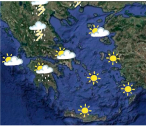
In more detail today, Tuesday (21/4), in the afternoon, we expect showers and sporadic thunderstorms in central and especially northern Greece. The rest of the regions will have generally clear weather.
The maximum temperature will reach 24 to 25 degrees in the eastern mainland and 20 to 22 degrees on the islands. In the evening, the mercury will drop to 16 to 17 degrees Celsius in the lowlands, while in the mountains, the chill will be felt.
Winds will be from southwestern directions and will reach 5 Beaufort in the Ionian Sea and 6 Beaufort in the southern Aegean.
In Attica, clear weather is expected. Winds will blow from southern directions and will reach 3 Beaufort. The temperature will range from 13 to 23 degrees. On the contrary, in Thessaloniki, showers and thunderstorms are forecast for the next few hours. Winds will blow in Thermaikos up to 5 Beaufort, and the temperature will range from 10 to 22 degrees.
On Wednesday (22/4) in central and northern Greece in the afternoon, we expect rain, thunderstorms, and snow in the mountains. Winds will gradually shift to north winds up to 7 Beaufort, and the temperature will drop significantly, even down to 10 degrees.
On Thursday (23/4), the change in the weather will extend almost to the rest of the country. The temperature will drop again, and snow will fall in the mountains. Gradually, the weather will improve.
Ask me anything
Explore related questions


