A gigantic “mega-tsunami” created when part of a mountain collapsed into the sea in Alaska is now being recognized as the second-highest wave ever recorded.
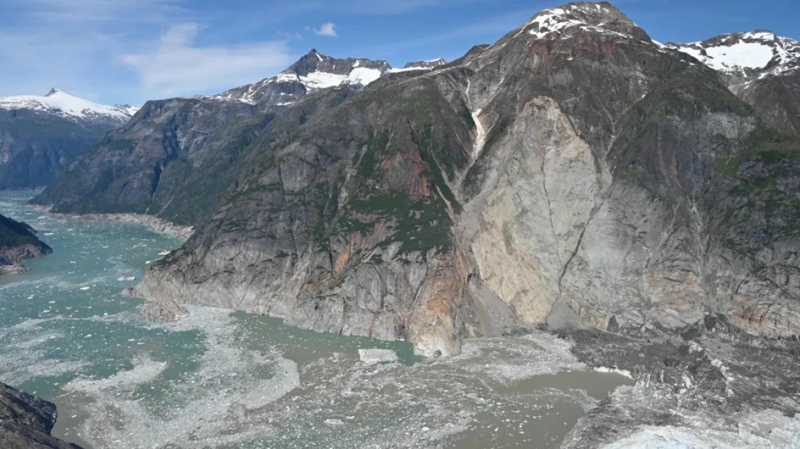
The incident occurred last summer in a remote fjord in southeastern Alaska and initially went almost unnoticed. However, a new scientific analysis revealed that the wave was caused by a massive landslide, when around 64 million cubic meters of rock — an amount equivalent to 24 Great Pyramids of Giza — plunged into the water in less than a minute.
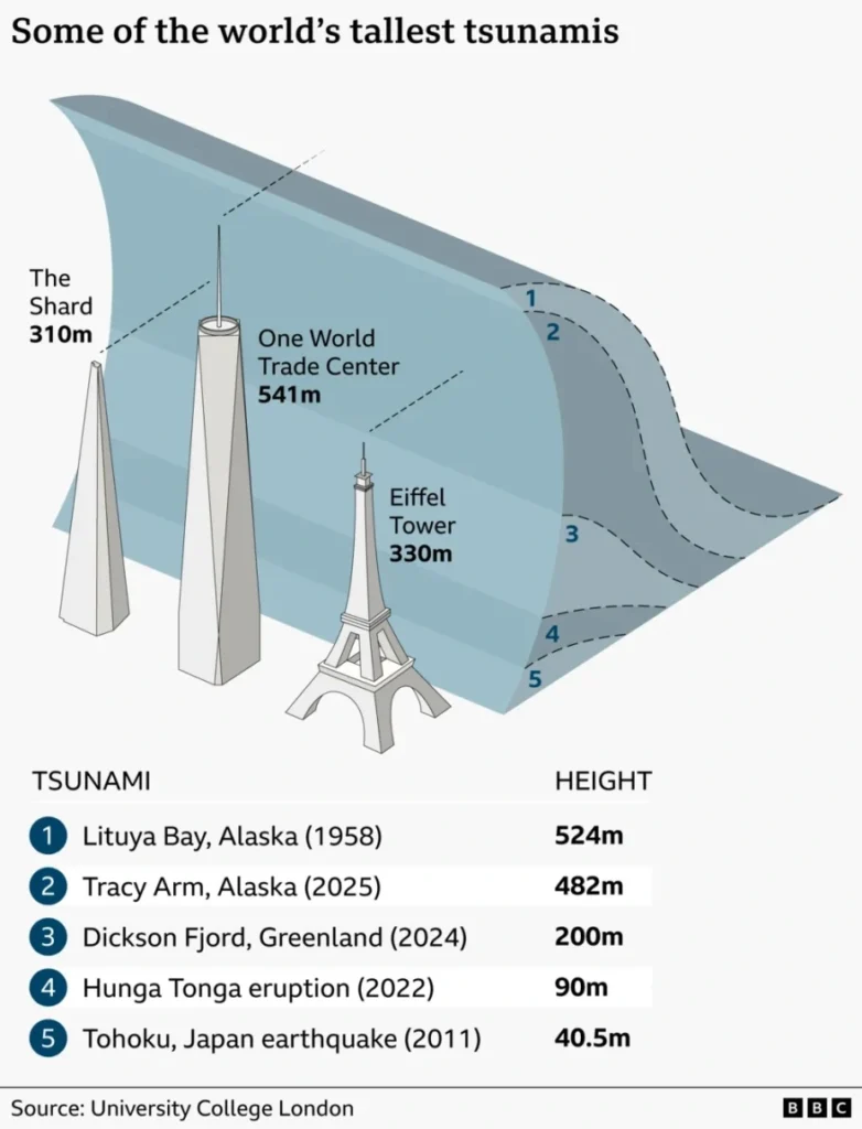
The force of the impact generated a massive wave that reached nearly 500 meters in height (482 meters), making it the second-largest “mega-tsunami” ever recorded worldwide. Scientists point out that only the fact that the event occurred in the early morning hours prevented a potential tragedy involving tourist cruise ships that frequently visit the area.
Alaska geologist Brentwood Higman, who visited the Tracy Arm fjord a few weeks after the event, described it as a “near miss disaster.” “We know there were people who came very close to being in the wrong place,” he said, adding: “It genuinely frightens me to think that we may not be so lucky in the future.”
So-called “mega-tsunamis” occur when landslides — caused either by earthquakes or unstable rock formations — fall into large bodies of water. Unlike conventional tsunamis, which originate in the open ocean due to powerful earthquakes or underwater volcanoes and can travel thousands of kilometers — such as the devastating 2011 Japan tsunami — mega-tsunamis are usually localized events that quickly lose intensity.
The 1958 largest mega-tsunami
The largest mega-tsunami ever recorded occurred in the 1950s and exceeded 500 meters in height. Specifically, it took place in 1958 in Alaska’s Lituya Bay after an earthquake measuring between 7.8 and 8.3 on the Richter scale, reaching 524 meters. The recent Alaska event is now considered the second most powerful in recorded history.
When Higman arrived at the fjord area, a popular cruise destination because of Alaska’s spectacular landscapes, he found broken trees scattered across the slopes and tossed into the water, while vast rocky areas had been stripped bare of soil and vegetation.
Alaska is considered especially vulnerable to such events due to its combination of steep mountains, narrow fjords, and frequent seismic activity. However, new research published in the journal Science argues that glacier melt caused by climate change is significantly worsening the risk of collapses.
Researchers combined field investigations, seismic data, and satellite imagery to reconstruct the sequence of events and estimate the true height of the wave.
Seismologist Stephen Hicks explained that the glacier had until recently acted as a natural “support” for the mountain. “The glacier helped hold this section of rock in place. But when the ice retreated, the base of the cliff was exposed, allowing the rock mass to suddenly collapse into the fjord,” he said.
He and his colleagues, who have studied tsunamis for decades, say they are deeply concerned about how frequently such incidents may occur in the future. “More and more people are now traveling to remote areas. Many of these cruises are organized so tourists can experience natural beauty and learn about climate change. But these are also dangerous places,” Hicks warned.
For his part, Higman said he has no doubt that the risk of mega-tsunamis is increasing significantly. “At this point, I’m fairly certain these events are not becoming just slightly more common, but vastly more common,” he said, estimating they may be “ten times more frequent than they were a few decades ago.”
Ask me anything
Explore related questions


