





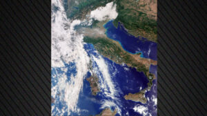
Just two weeks after its launch, the Copernicus Sentinel-3C satellite has sent back its first images and measurements from two of its key instruments, confirming, as the European Space Agency (ESA) points out, that the satellite is operating perfectly for monitoring the state of Earth’s oceans, land and atmosphere.
The first images include views of Italy, the Arctic and the Caribbean, along with measurements of the height of Greenland’s ice sheet and sea-surface elevation.
The satellite is the third in the Sentinel-3 Earth observation series and will continue to provide environmental data that are essential for a wide range of applications. Its observations are valuable for weather forecasting and for monitoring long-term changes associated with climate change.
Over land, it monitors drought and wildfires, maps land use, assesses vegetation health and measures the levels of rivers, lakes and polar ice sheets. Over the oceans, it measures sea-surface temperature, colour and height, as well as the thickness of sea ice.
The European Space Agency is still preparing the satellite for full operational service – a complex process that will take another five months.
Ask me anything
Explore related questions




