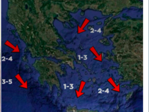





Greece is set for deteriorating weather from the early hours of Sunday (1 November), with heavy rain, thunderstorms and possible localised hail across much of the country. The Hellenic National Meteorological Service (HNMS) has issued an emergency weather warning, forecasting severe conditions until at least Monday (2 November), particularly in western and northern Greece and the eastern Aegean islands. According to Proto Thema meteorologist Giorgos Tsatrafyllias, the storm will follow a characteristic “pi” (Π) pattern and is expected to persist until Tuesday (3 November).
The change in weather is being driven by a low-pressure system moving from Italy towards Greece, bringing organised bands of rain and thunderstorms.
The most severe weather is expected in western Greece, Macedonia, Thrace, the eastern Aegean islands and the Dodecanese, forming the geographical pattern meteorologists describe as a “pi-shaped” storm.
Particular caution is advised in areas where thunderstorms could bring heavy rainfall over short periods, as well as localised hail.
Where heavy rain and thunderstorms are expected
Weather conditions are forecast to deteriorate from Sunday (1 November 2026) until at least Monday (2 November 2026), particularly in western and northern Greece and the eastern islands, with heavy rain and thunderstorms and a possibility of localised hail.
More specifically, locally heavy rain and thunderstorms are forecast in the following areas:
Sunday, 1 November
- Ionian Islands: Until midday.
- Epirus, western Central Greece, and western and southern Peloponnese: Until the afternoon.
- Central and eastern Macedonia: From the morning until late at night.
- Northern and eastern Aegean islands: From the afternoon until late at night.
- Dodecanese: From the afternoon onwards.
Monday, 2 November
- Ionian Islands: At intervals from the morning.
- Epirus, western Central Greece and western Peloponnese: From the afternoon until late at night.
- Dodecanese: At intervals until the evening.
Tsatrafyllias: How the storm will develop on Tuesday
Although the HNMS warning currently covers the period until Monday, Proto Thema meteorologist Giorgos Tsatrafyllias’s forecast extends to Tuesday (3 November).
According to Tsatrafyllias, the unsettled weather is expected to continue, with rain and thunderstorms initially affecting western Greece.
The most severe conditions are then forecast to move towards central and eastern Macedonia, Thrace and the eastern Aegean islands.
Elsewhere in the country, weather conditions are expected to improve gradually.
What to expect in Attica
Based on the latest forecast data, Attica is not among the areas currently expected to face an elevated risk from heavy rain and thunderstorms.
Tsatrafyllias said localised showers cannot be ruled out across the Athens metropolitan area, but there are currently no signs of a particularly severe deterioration in the weather.
The development of the weather system will depend on the path of the low-pressure system and the latest forecast data.
Authorities on heightened alert
The HNMS warning has prompted the Civil Protection authorities to step up their readiness, with the relevant services on heightened alert to deal with potential problems caused by the severe weather.
Particular attention is being paid to the risk of flooding in areas forecast to experience heavy thunderstorms, especially if large amounts of rain fall within a short period.
Members of the public are advised to take extra care when travelling and follow official updates, as the intensity and geographical distribution of the weather may change.
Ask me anything
Explore related questions