




MyStreet began as a tool for monitoring tables and chairs occupying public squares and pavements. It is now evolving into something much broader. The app is becoming a “one-stop shop”, bringing together on a single digital map everything people need or might need: where to find an electric vehicle charging point and whether it is available; the nearest safe assembly point in an emergency; the locations of ramps, crossings for people with disabilities and defibrillators; as well as a digital channel for reporting problems to the local authority.
As with almost all major ideas that ultimately make our lives easier, the principle is simple: citizens should not have to open different apps and websites to find information about the public space around them. Whatever they are looking for – whether they are facing an emergency and need reliable, official information within seconds, such as the location of a shelter or a nearby available defibrillator, or simply need information for everyday life – it should be available through a single app, with an interactive map and multiple layers of data. The service will, of course, be free and without intrusive advertising or other unwanted information.
Everything in one app
The vision of creating a digital one-stop shop was outlined to Proto Thema by Digital Governance and Artificial Intelligence Minister Dimitris Papastergiou.

“MyStreet began with an issue that concerns us all: being able to walk along pavements and use public spaces without obstacles. It is now evolving into a central geospatial information app, bringing together on one map information we need when travelling. Electric car drivers can see where a charging point is located and, now, whether it is available or in use,” he said.
The minister added that “information on accessibility infrastructure, such as ramps and crossings for people with disabilities, as well as the locations of defibrillators, will gradually be added. We want citizens to find all the information in one place, without having to search through different sources. The aim of Prime Minister Kyriakos Mitsotakis’s government is to make everyday life simpler for citizens. At the Ministry of Digital Governance and Artificial Intelligence, we continue to work on initiatives that improve everyday life by making use of the opportunities offered by technology.”
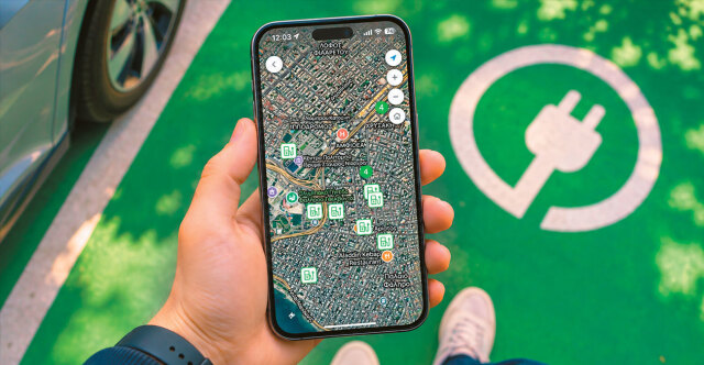
The latest upgrade to MyStreet is aimed at electric vehicle drivers. Through the app’s interactive map, they can search for charging points in the area they are interested in, check the power output and availability of chargers, and receive directions to reach them.
Charging points are marked on the map in green, with a dedicated charger icon that makes them easy to distinguish from other information. By tapping on a location, users can see its name and address, the provider operating it, its unique identification code, the power output of each charger and its availability.
The status of chargers is also indicated by colour. Green means that a charger is available, while orange indicates that it is in use. At locations with more than one charger, drivers can check the status of each one individually. In practice, this means they can find out whether a charging space is free before setting off, without having to travel to the location to check.
The final step is getting there. By selecting “Directions”, users can request guidance to the charging point that suits their needs. In this way, searching, checking availability and getting directions can all be done from the same point on the map.
The charger’s power output is particularly important to drivers because it determines how long their car will take to charge. With this information available before they set off, they can choose a location that fits their schedule.
For drivers, using the feature is straightforward and involves just four steps:
- Open the app and move the map to the area of interest, whether it is their current location or somewhere they intend to visit.
- Find charging points marked in green with the charger icon.
- Select a location to see which provider operates it, the power output of each charger and which ones are available (green) or in use (orange).
- Tap “Directions” to receive guidance to the location. The unique identification code displayed for each charging point helps users identify it precisely, which is useful when several charging locations are close together.
If the 112 emergency number is said to save lives, MyStreet is designed to go a step further. The same map in the app also displays safe assembly points for emergencies. Citizens can locate them in areas of interest, whether near their home, their workplace or their children’s school, and know in advance where they are.
The words “in advance” are crucial. During an earthquake, for example, or another emergency, neither time nor composure is in plentiful supply. Knowing where to go is valuable when people have already looked up the information and are familiar with it – or when they can receive live guidance on a map.
The next phase will see the addition of new geospatial data on the accessibility of public spaces. This will include information on infrastructure for people with disabilities, such as crossings, pavement ramps and entrance ramps. For someone using a wheelchair, a parent with a pushchair or an older person with limited mobility, knowing where a ramp or accessible crossing is located can determine the route they take. This information will complement the existing data on electric vehicle charging points and safe assembly locations.
The National Register of Defibrillators is also scheduled to be integrated at a later stage. This will allow citizens to locate defibrillators through the app – information that could prove critical in the event of cardiac arrest.
The approach is gradual: each new category of data is added as a separate “layer” to the same map, without users having to learn how to use a new app or install anything else. Alongside information on permits for the use of public spaces, charging points and safe assembly locations, accessibility infrastructure and defibrillators will also be included.
The stated aim is for the map to bring together an increasingly wide range of useful information about getting around and accessing the city, as well as staying safe in emergencies.
How it started
To understand how the app has evolved, it is worth looking at where it began. MyStreet was designed along the lines of MyCoast, the app covering beaches, and initially focused on transparency in the use of public spaces in cities.
Through the app, citizens can find out about permits granted for the use of public spaces and report possible violations. The most common examples are businesses exceeding the permitted area for tables and chairs, and obstructing access for people with disabilities – two problems pedestrians frequently encounter on pavements and in public squares.
The app is linked to the Register of Permits for the Use of Public Spaces. Reports submitted by users are automatically forwarded to the Register’s digital platform so that the relevant municipality can handle them.
The link to the Register is what makes the app a monitoring tool rather than simply a source of information. Citizens can not only see whether a business has a permit to use public space, but also compare the authorised area with what they actually find on the pavement. If they spot a discrepancy, they can report it from the same location.
The process is designed to ensure that citizens’ reports do not simply end up in a drawer. Municipalities have an overview of both the published permits and the reports submitted. Using this information, they can assign inspections to the Municipal Police or, where no municipal police force exists, to the Hellenic Police.
Reports submitted under users’ real names are verified through TaxisNet, the Greek government’s online tax and public services authentication system. Citizens can follow the progress of their complaint through the app and see what stage it has reached.
There are specific limits on the submission of complaints: each user can submit up to three complaints per day for each type of violation, and reports are accepted only for locations within 500 metres of the user’s current position.
Verification through TaxisNet
The distance restriction means that complaints must be submitted by someone who is close to the location and can see the problem, rather than remotely. The combination of TaxisNet verification, a geographical restriction and a daily limit gives municipalities reports linked to a specific location and a specific moment. This makes it easier to organise inspections, as the relevant service knows exactly where it needs to go and what issue it needs to investigate.
Alongside the addition of new data to the map, another priority is improving the entire process, from the submission of a report to the inspection and response by the relevant authorities.
To support this, the relevant ministries and the Central Union of Municipalities of Greece (KEDE) have already begun training and assisting municipalities with the registration and management of data. The quality of the map depends to a large extent on how complete and up to date the information entered by the municipalities themselves is.
A look at MyStreet’s development makes the direction clear. The app began with a specific purpose: ensuring transparency in permits for the use of public spaces and allowing citizens to report violations. Today, the same map shows charging points, including the status of each charger, as well as safe assembly points. Tomorrow, it will also show ramps, accessible crossings and defibrillators.
What all these features have in common is public space and the movement of citizens through it – by car, on foot, in a wheelchair or in an emergency. Instead of having to consult separate sources, the information is brought together in one place.
MyStreet is available free of charge on the App Store and Google Play for iOS and Android devices.
To submit a report under their real name, users must verify their identity using their TaxisNet credentials. They can then track the progress of each complaint through the app itself.
What is changing
For electric vehicle drivers: They can see on the same map where charging points are located, which provider operates them, the power output of each charger and whether it is available or in use. By selecting “Directions”, they can receive guidance to the location that suits them.
For pedestrians: They can find out about permits for the use of public spaces in their neighbourhood, check whether a business has exceeded the area allocated to it and report it, then follow the progress of their complaint.
For people with disabilities: They can already report cases in which their access is obstructed. In the next phase, they will also be able to see accessibility infrastructure on the map, including crossings, pavement ramps and entrance ramps.
For anyone facing an emergency: They can find out in advance where safe assembly points are located in their area. Once the National Register of Defibrillators has been integrated, they will also be able to locate the nearest defibrillator.
For municipalities: They have a consolidated overview of permits and reports, can arrange inspections by the Municipal Police or the Hellenic Police, and receive training and support in managing the data.
Ask me anything
Explore related questions