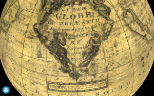
No matter how accustomed we’ve grown over the centuries to flat maps of the world, they can never be perfectly accurate. Strictly speaking, no map can perfectly capture the territory it describes (an impossibility memorably fictionalized by Jorge Luis Borges in “On Exactitude in Science”), but there’s a reason we also call the Earth “the globe”: only a globe can represent not just the planet’s true shape, but the true shape of the land masses on which we live. This is not to say that globes have always been accurate. Like the history of mapmaking, the history of globe-making is one of educated (or uneducated) guesses, free mixture of fact and legend, and labels like “terra incognita” or “here be dragons.” You can see that for yourself in the British Library’s new online historic globe archive — and not just through flat photographs and scans.
“The archive presents 3D models of 11 globes — a subset of the library’s historic maps collection — that can be rotated and zoomed into for greater detail at every angle,” writes Hyperallergic’s Sarah Rose Sharp. She points to one in particular, “stunning 1602 celestial globe by Dutch cartographer Willem Janszoon Blaeu, first produced in 1602. In addition to representing the constellations as their fantastic and mythological namesakes, it identifies a nova in the constellation of Cygnus which Blaeu had personally observed in 1600″.
Primary schools reopen in Greece – PM Mitsotakis visits Athens Primary school
See the Globes HERE
Ask me anything
Explore related questions


