The weather changes from today through Saturday with thunderstorms and dropping temperatures, according to meteorologists.
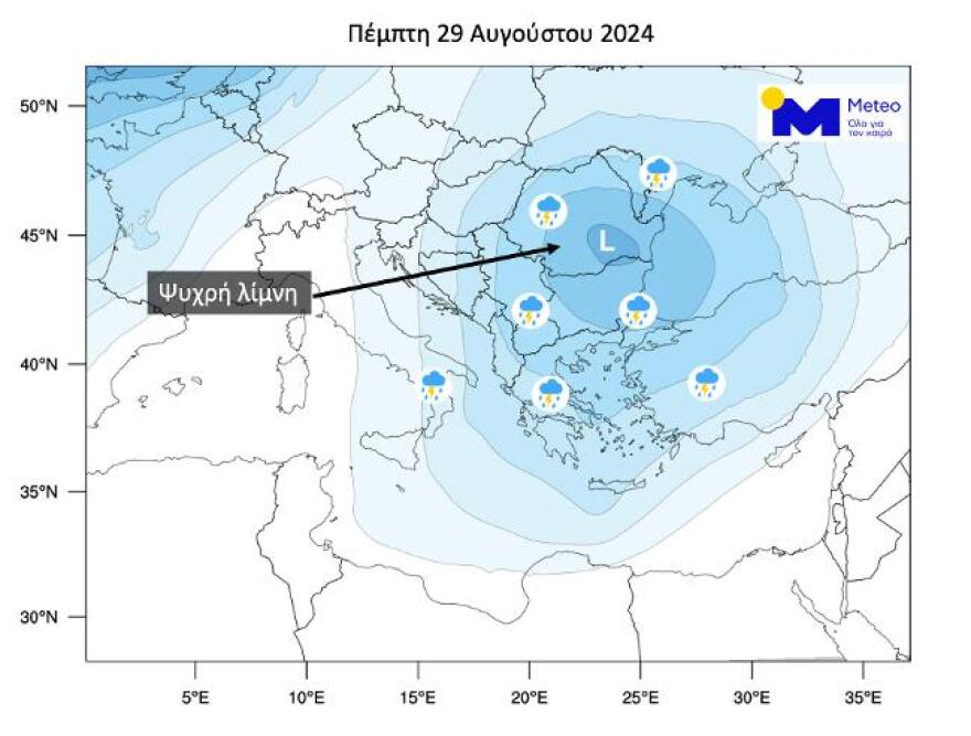
Unusual for the time of year is the atmospheric circulation over the Eastern Mediterranean, as a “Cold Lake” (i.e. a cut-off mass of relatively cold air masses) is affecting our region (Map 1). Remarkable precipitation is forecast across much of the Balkans, southern Italy, and Turkey through Saturday, August 31, 2024.

Map 1. The area of “Cold Lake” is rendered in blue and blue shades. The storm icons indicate areas that will receive severe weather on Thursday 08/29/2024.
In our country, the presence of cold air masses over warm surface air masses already creates conditions of instability, i.e. they favor the formation of thunderstorms mainly over the continental areas in the evening hours. From today and at least until Saturday 31/8 the instability is expected to increase, with storms affecting a large part of the country. With the current forecast data, there is little chance of hail, but there will be an increased risk of flooding, as a high rate of rainfall and a large number of power outages are predicted.
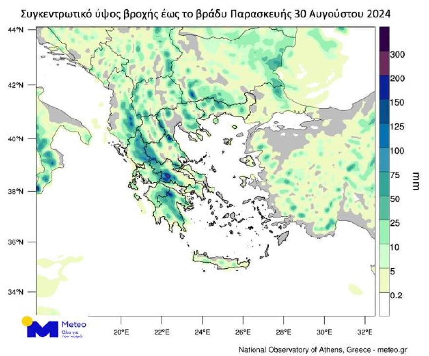
The next map (Map 2) shows the total rainfall in millimeters predicted by the numerical forecast model of the National Observatory of Athens/meteo.gr until the evening of Friday 30/8.

Map 2. Forecast map of cumulative rainfall between Wednesday 28 and Friday 30 August 2024, from the numerical model of the National Observatory of Athens/meteo.gr.
The temperature will drop slightly on the mainland and will be close to normal for the season.
It is worth noting that the “Cold Lake” phenomenon causes conditions in the atmosphere that are extremely difficult to predict with great accuracy by forecasting models, which causes uncertainty as to which areas will receive the highest rainfall. Forecasts will be updated regularly and will be followed by further communications with updated forecast data.
Weather instability, which will favor the occurrence of thunderstorms, until the end of August, warned the Director of Research of the National Observatory of Athens, Kostas Lagovardos.
Lagwardos: Increased risk of flooding
In a post he stressed that our country is approaching an unusual for the season “cold lake”, a cut-off mass of cold air masses.
“From Thursday 29/8 and at least until Saturday 31/8 the instability is expected to increase, with storms affecting much of the country. With the current forecast data (Wednesday 28/8), the possibility of hail is low, but there will be an increased risk of flooding, as a high rare rainfall and a large number of electrical discharges are predicted. Temperatures will drop slightly in the mainland and will be close to normal for the season,” he said in his post.
Weather – Kolydas: What is a cold lake
At the same time, the director of the National Weather Service, Thodoros Kolydas, explains in a post what a coldr lake is. As he underlines: “the next three days’ weather instability is due to the detached low accompanied by a cool mass in the upper atmosphere as we have been reporting for several days. The air masses in the upper low will contrast with the warm and wetter air masses in the lower layers. The interaction of cold upper-atmosphere gas masses (cold pool), warm ground and adjacent air (at 850mb) under conditions of increased humidity favors the stirring of unstable gas masses aloft, creating clouds of vertical growth (cumulus), which are precursors to storm clouds (cumulonimbus- Cb). For this reason, we observe that precipitation is mainly localized over continental regions , where the highest temperatures also develop. This is cold lake weather.”
He adds: “The term “cold lake” is a translation of the term “Cold Pool” (more accurately it would be “Cold Pool”). So this cold pool is a cold area surrounded by hot masses. The existence of cold gas masses over warm and moist gas masses near the ground leads to the creation of instability. Instability is a necessary condition for the formation of storms, while the other two conditions are the existence of moist gas masses and a cause of lifting of the gas masses.”
Kallianos: 100 difficult hours coming – “Limit your travel”
For his part, meteorologist Yannis Kallianos stresses that this instability is expected to continue until Sunday.
This means that “four 24 hours (Thursday, Friday, Saturday, Sunday), almost 100 hours will be under conditions of instability. This means, not to be misunderstood, that the day will start well with sunshine, but don’t be fooled because from noon to afternoon, the clouds will quickly thicken and we will have these showers, rains and local storms mainly in the Ionian and continental parts and not so much in the Aegean,” stressing that the continental parts include from the Peloponnese to Thrace.
As he goes on to explain, thunderstorms can be particularly intense which may be accompanied by localized hail from strong currents. “We should be prepared and if we see that we have such situations, from noon until the afternoon, to limit our movements,” Yannis Kallianos stressed, noting that the mercury will recede in the coming days and temperatures will be more tolerable.
Sakis Arnaoutoglou: In which areas it will rain on Thursday
Thursday in Thursday, Thursday, Thursday, Thursday, Thursday, Thursday.
At the same time, the areas where on Thursday there is a high probability for a passage of a shower or storm at noon – afternoon – early evening is presented by Sakis Arnaoutoglou in a post on social media.
The weather today
Clouds are expected on the mainland, in the Ionian Sea, the North Aegean and Crete. Local showers and occasional thunderstorms will occur initially in the mountainous mainland. Gradually until noon the phenomena will intensify and will extend to the rest of the continent, the Ionian Sea and the west of Crete. There is a possibility of hail mainly for the mountainous continents. The phenomena will be strong in places. Their weakening is expected from the early evening hours. Dust concentrations in the atmosphere will be relatively increased.
The temperature in Western Macedonia will range from 17 to 29 degrees Celsius, in the rest of Macedonia and Thrace from 19 to 33, in Thessaly from 21 to 35, in Epirus and Western Central Greece from 19 to 31, in the rest of Central Greece from 20 to 33, in the Peloponnese from 18 to 36, in the Ionian Islands from 19 to 32, in the North and East Aegean Islands from 20 to 33, in the Cyclades and the Dodecanese from 22 to 33 and in Crete from 20 to 34 degrees Celsius.
The winds in the North Aegean Sea will initially blow from northeastern directions from 2 to 4 Beaufort, but will gradually become westerly of the same intensity until the early evening hours. In Thermaikos the winds will blow from southerly directions from 2 to 4 Beaufort. In the Central Aegean Sea the winds will blow from northern directions from 2 to 4 Beaufort. In the Southern Aegean, winds will blow from westerly directions 3 to 5 Beaufort. In the Ionian Sea the winds will blow from northwestern directions 2 to 4 Beaufort.
TOMORROW FRIDAY 30-08-2024
In the Ionian Sea, western Central Greece and northwestern Peloponnese, unstable weather with local rain and occasional thunderstorms, possibly heavy in places in the morning hours.
In the rest of the country the weather will initially be generally clear but from the midday hours clouds will develop in the Sporades, Euboea and gradually in the mainland and Crete where local showers and sporadic thunderstorms will occur, possibly locally strong mainly in the eastern and northern mainland.
Improvement is expected from the evening hours in most areas except for the southern parts of Macedonia, eastern Thessaly and the Sporades.
Winds will blow from the north from 3 to 5 and locally in the eastern Aegean Sea 6 Beaufort.
The temperature will drop slightly further. In the mainland, the Ionian Sea, the Dodecanese and Crete it will reach 30 to 32 and locally 33 degrees Celsius and in the rest of the island country 27 to 29 degrees Celsius.
SATURDAY 31-08-2024
In the southern parts of Macedonia, the Sporades, Evia, eastern Thessaly and eastern Central Greece, unstable weather with showers and occasional thunderstorms, possibly strong in places.
In the rest of the country the weather will initially be almost clear and from the midday hours clouds will develop in the mainland, the Ionian Sea and Crete and there will be local showers or rain, while in the mainland there will be sporadic storms, possibly strong in places.
Winds in the west will be variable 3 to 4 and in the Ionian Sea will blow from northern directions, locally 5 Beaufort. In the east it will blow from northern directions 3 to 5 and locally in the Aegean Sea 6 Beaufort.
The temperature will not change significantly. It will reach in the mainland, the Ionian Sea, the Dodecanese and Crete 30 to 32 and locally 33 degrees Celsius and in the rest of the island country 27 to 29 degrees Celsius.
SUNDAY 01-09-2024
Initially unstable weather in the Sporades, Evia and in eastern Thessaly and eastern Sterea with local showers and occasional thunderstorms, possibly heavy in places, while increasing clouds with local showers and possibly isolated thunderstorms will also occur in the southern Ionian Sea, southern Peloponnese, Cyclades and Crete.
In the rest of the country the weather will initially be almost clear. In the midday and afternoon hours clouds will increase in places on the mainland and local rain and isolated thunderstorms will occur, mainly in the central and southern mainland.
Improvement is expected from the evening hours in most of the country and a few showers will occur only in Crete and the Dodecanese.
Winds will blow from the north from 3 to 5 and locally in the Aegean Sea 6 Beaufort.
The temperature will rise slightly in the west and north.
MONDAY 02-09-2024
In Crete and the Dodecanese clouds with a few local rain showers or showers until the afternoon.
In the rest of the country the weather will be almost clear. In the midday and afternoon hours clouds will increase in places on the mainland and local rain and isolated thunderstorms will occur, mainly in the western and northern mountainous areas.
The winds will blow from the north from 3 to 5 and locally in the Aegean Sea 6 Beaufort.
The temperature will rise slightly further.
Ask me anything
Explore related questions


