Bad weather continues for another day in Greece as according to the EMY forecast, today Sunday (1/9) localized heavy showers and thunderstorms in Sporades, Evia, Peloponnese, and Crete.
Consequently, the forecast reports intermittent clouds until the afternoon with rain and thunderstorms mainly in the central and southern mainland and the Aegean. Winds will blow from northerly directions 3 to 5 and locally in the Aegean up to 6 Beaufort. However, the temperature will rise slightly to its maximum values in the central and northern regions where it will reach 32 to 33 degrees Celsius. In other areas, it will reach 29 to 31 degrees.
As for the weather in Athens, according to the National Meteorological Service, it is forecast to be cloudy again and in the afternoon there will be local rain and thunderstorms.
MACEDONIA, THRACE
Weather: In western Macedonia a few clouds, partly cloudy with a possibility of local rain in the mountains in the afternoon. In the rest of the regions, clouds intermittently increased with occasional local rain or isolated thunderstorms until the early morning hours mainly in the southern parts of central Macedonia.
Winds: From northern directions 3 to 4 and in the east locally 5 Beaufort.
Temperature: From 17 to 32 degrees Celsius. In western Macedonia, the minimum is 3 to 4 degrees lower.
IONIAN, EPIRUS, WESTERN MAINLAND, PELOPONNESE
A few clouds will increase in the afternoon when in the western mainland, western Peloponnese, and possibly in southern Ionian and mountainous areas of Epirus there will be showers and thunderstorms. The phenomena in the western Peloponnese are likely to be temporarily strong.
Winds: variable 3 to 4 Beaufort and in the afternoon hours in the Ionian Sea western northwestern.
Temperature: From 21 to 33 and in the southern Ionian Sea and the western Peloponnese up to 31 degrees Celsius. In the interior of Epirus, the minimum is 4 to 5 degrees lower.
In the north and south-eastern parts of Europe, the temperature will be 4.5 to 4.5 degrees Celsius and 4.5 to 4.5 degrees Celsius.
EASTERN MAINLAND, EUBOIA, PELOPONNESE
Weather: A few clouds at times, locally increasing. Local showers and thunderstorms will occur until noon in Evia and the afternoon in the rest of the regions. The phenomena in the eastern Peloponnese and Evia are likely to be occasionally strong.
Temperature: From 19 to 31 degrees Celsius.
Temperature: From 19 to 31 degrees Celsius.
CYCLADES
Weather: A few clouds, occasionally increasing with local showers and thunderstorms until the afternoon. The phenomena in Crete are likely to be strong at times.
Winds: 4 to 5 Beaufort north-northwest and occasionally in the Cyclades locally 6 Beaufort.
Temperature: From 22 to 29 degrees Celsius.
From 22 to 22 degrees Celsius.
ANATOLIAN AEGEAN ISLAND – DODECANESE
Winds: 4 to 5 Beaufort north-northwest.
Temperature: From 22 to 30 degrees Celsius.
THESSALY
Weather. The phenomena in the Sporades may be strong at times.
Winds: From northern directions 3 to 4 Beaufort and from the afternoon variable.
Temperature: From 19 to 33 degrees and in the Sporades up to 29 degrees Celsius.
ATTICA
Weather: A few clouds, partly increasing in the afternoon – afternoon, when local rain and thunderstorms will occur.
This may occur in the afternoon and there may be some rain and thunderstorms in the afternoon and afternoon.
Winds: From northern directions 3 to 4 and in the east locally 5 Beaufort.
Temperature: From 21 to 31 degrees Celsius.
THESSALONIKI
Weather: A few clouds, partly cloudy with a possibility of occasional local rain in the afternoon – afternoon in the mountains.
In the afternoon and the evening, in the afternoon and in the afternoon, in the afternoon and in the afternoon, in the afternoon.
Winds: From northern directions 3 to 4 Beaufort and from the afternoon variable.
From north-eastern Europe and north-eastern Europe from north-eastern Europe and the afternoon. Temperature: From 19 to 32 degrees Celsius.
MONDAY 02-09-2024
Initially generally clear weather across the country with a few occasional local clouds in the east. In the midday – afternoon hours clouds, partly cloudy in the mainland, Crete and the Dodecanese, where there will be local showers or rain, and in the northeast, west, and south mainland mainly in the mountains there will be isolated thunderstorms. Improvement in the evening hours.
Winds will be variable 3 to 4, in the south will blow from the west with the same intensity and in the southeast locally 5 Beaufort.
Temperatures will rise slightly and will reach 30 to 31 and locally 34 to 35 degrees Celsius in the mainland, the Ionian Sea, the Dodecanese and Crete, and 28 to 30 degrees Celsius in the rest of the island country.
TUESDAY 03-09-2024
Initially generally clear weather across the country with a few local clouds. In the midday – afternoon hours clouds will increase in the mainland, the northeastern Aegean islands, and Crete, where local rain or rain will occur, and mainly in the western and southern continental highlands isolated thunderstorms will occur. Improvement in the evening hours.
During the morning and evening hours in the continental areas, visibility may be locally limited.
Winds will blow from the north from 3 to 4 Beaufort and in the Aegean Sea locally from 5 to 6 Beaufort.
Temperatures will not change significantly and will reach 31 to 33 and locally 34 to 35 degrees Celsius in the mainland, the Ionian Sea, the Dodecanese and Crete, and 28 to 30 degrees Celsius in the rest of the island country.
WEDNESDAY 04-09-2024
Initially generally clear weather throughout the country with a few local clouds. In the midday – afternoon hours clouds will increase in the continental areas, where local rain or rain will occur, and in the northern, western, and southern continental areas, mainly in the mountains, isolated thunderstorms will occur.
Winds will blow from the north from 3 to 4 Beaufort and in the Aegean Sea locally from 5 to 6 Beaufort.
Temperatures will not change significantly.
THURSDAY 05-09-2024
Initially generally clear weather across the country with a few local clouds. In the midday – afternoon hours clouds will increase in the mainland, where there will be local showers or rain, and in the north, west, and south of the continent, mainly in the mountains, isolated thunderstorms will occur.
The winds will blow from the north from 3 to 4 Beaufort, and in the Aegean Sea locally 5 to 6 and sometimes 7 Beaufort.
Temperatures will not change significantly.
Most rain in the Sporades, Evia, and Peloponnese
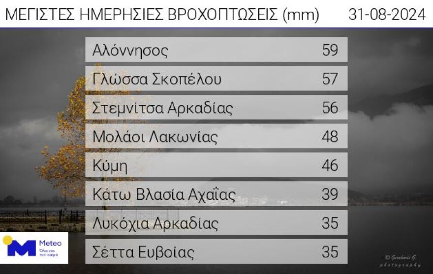
Rain and thunderstorms occurred on Saturday (31/8), mainly in Sporades, Euboea and Peloponnese.
According to the recordings of the network of automatic meteorological stations of meteo.gr / National Observatory of Athens, the highest cumulative precipitation height, until about 18:00, was recorded in Alonissos and was equal to 59 mm. The relevant table shows the 8 network stations that recorded the highest rainfall heights up to about 18:00 on Saturday.

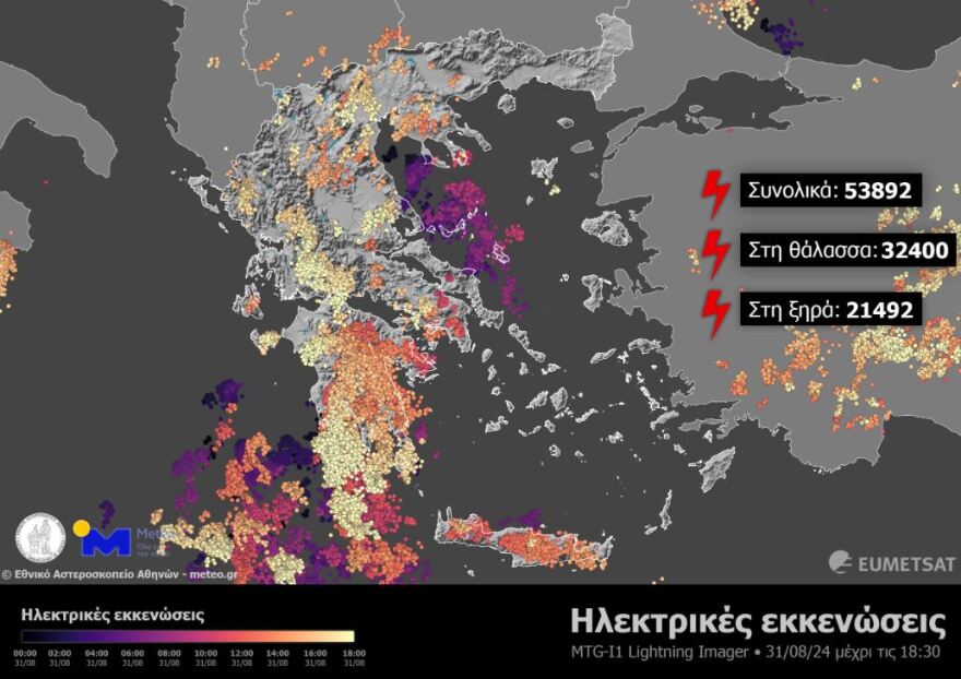
The map below notes the electrical discharges recorded by the MTG-I1 satellite’s Lightning Imager instrument from the beginning of the 24 hours to 18:30 GMT. As it shows, it recorded 53,892 discharges, 21,492 of which were over dry and 32,400 over the sea.
Intense lightening activity in the afternoon and midday over the Peloponnese as well as morning activity in the Sporades which was accompanied by large amounts of precipitation.

Ask me anything
Explore related questions


