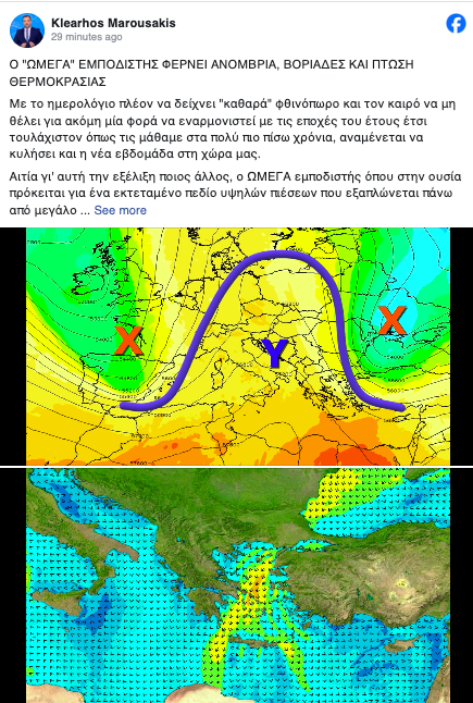
Meteorologist Klearchos Marousakis from OPEN has highlighted that snowy conditions, along with some rain, will dominate the weather until mid-week. This is largely due to the “Omega Weathercaster” phenomenon, which creates an atmospheric block over southern and central Europe, stopping typical storm systems from moving eastward.

Key Weather Updates:
- Minimal Rain: Limited precipitation is expected, mainly in the eastern regions.
- “Omega Blizzard”: This weather pattern, named after the Greek letter Omega, is blocking storms from reaching Greece by forcing them to reroute. This is contributing to cooler conditions and the approaching autumnal shift.
When Will the Temperature Drop?
From Wednesday onward, temperatures will take a sharp dive. The Omega system will trigger strong north winds in the Aegean Sea, reaching 6 to 8 Beaufort in certain areas. These winds will pull in cold air from northeastern Europe, causing temperatures to drop to 20-23°C across the country, particularly chilling in central and northern Greece.
Omega Weather System Explained
Marousakis describes the “Omega” system as a high-pressure field that dominates much of Europe, shaping an Omega-like pattern on weather maps. This setup prevents the arrival of traditional bad weather systems, ushering in colder air and bringing the first signs of winter-like conditions.
Potential for Severe Weather
There is a low-pressure system forming near Italy that could disrupt the current anticyclone, possibly leading to stormier conditions in western Greece. This system will need close monitoring as it could gain tropical-like characteristics if it interacts with the warm seas and fights against the blocking anticyclone.
Autumn temperatures are set to make a return in the coming days, with a gradual drop in mercury levels due to the strengthening of northerly winds across Greece. Despite the cooler air, the skies will remain largely clear with little to no rainfall until the end of the week, continuing the drought conditions that have been prevalent.
According to meteorologist Panagiotis Giannopoulos from ERT, the weather will begin to shift from Wednesday, when the north winds intensify in the Aegean Sea, bringing a noticeable temperature drop. By Thursday, temperatures will return to more typical autumn levels, and by the weekend, they may fall slightly below average.
Rainfall Outlook:
- A few light showers may affect parts of Macedonia and Thessaly on Thursday, with more significant rainfall potentially arriving on Friday as a weather system approaches from Italy.
- However, there’s uncertainty about whether this system will bring widespread rain, and it’s likely that any substantial rainfall will be limited over the next ten days.
Regional Forecasts:
- Attica: Expect thin cloud cover today, with temperatures reaching up to 28°C, cooling down to 25°C by Thursday.
- Thessaloniki: Similar clear skies with occasional clouds and a temperature drop mid-week, reaching 24°C today.
Winds and Temperature:
- Winds will blow from the north, particularly strong in the Aegean, reaching up to 6 Beaufort in some areas.
- Temperatures will range from 23-28°C, with cooler conditions expected in northern and central Greece by midweek, with highs closer to 20-24°C.
By Wednesday, cooler air will begin to spread, making the weather feel more like autumn, especially during the night and early morning hours.
Ask me anything
Explore related questions


