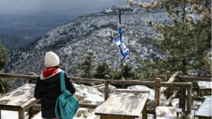
A significant weather deterioration is expected in the country today and tomorrow, with a sharp drop in temperature (by 12 to 15 degrees overall), heavy rainfall, thunderstorms, and snowfall in mountainous and semi-mountainous areas, as well as in some lower-altitude regions of eastern mainland Greece. Gale-force north-northeastern winds reaching 8 and locally 9 Beaufort will blow in the Aegean and the eastern mainland from this afternoon until Wednesday night.
According to EMY director Theodoros Kolydas, temperatures are expected to return to normal levels after the weekend.
🌡️🌡️🌡️Η ΑΠΟΤΟΜΗ "ΚΑΤΗΦΟΡΑ" ΚΑΙ Η ΑΡΓΗ ΑΛΛΑ ΒΑΘΜΙΑΙΑ ΑΝΟΔΟΣ ΤΟΥ ΥΔΡΑΡΓΥΡΟΥ ΣΤΗΝ ΑΘΗΝΑ.
— Theodoros Kolydas (@KolydasT) March 17, 2025
✅Το παρακάτω μετεώγγραμμα αντικατοπτρίζει σε μεγάλο βαθμό την πορεία που θα ακουθήσουν οι θερμοκρασίες τις επόμενες ημέρες στις περισσότερες περιοχές, με την επαναφορά τους σε κανονικές τιμές… pic.twitter.com/YNUbKEX2M2
Cause of the Weather Deterioration
The rapid deterioration is due to the movement of cold air masses affecting the country from north to south. As shown in Figure 1, the temperature drop will continue until the night of Wednesday, March 19, while a gradual rise is expected from Thursday, March 20. However, temperatures will remain unseasonably low on Thursday and Friday.
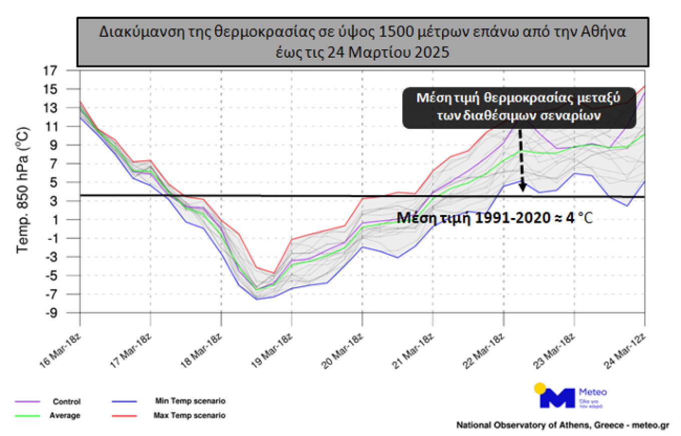
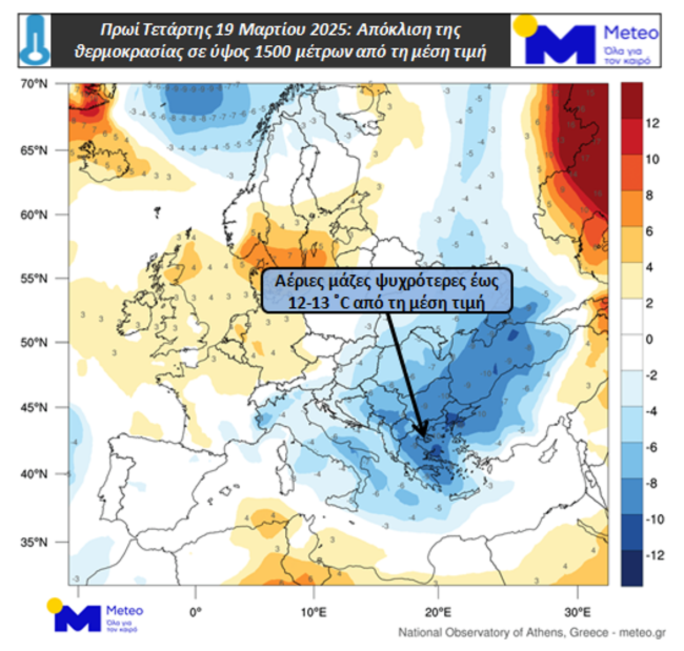
Figure 2 illustrates the deviation of temperature at 1500 meters above sea level from the 1979–2010 average, showing that on the morning of Wednesday, March 19, the temperature at this altitude will be 12–13°C lower than the average.
- Figure 1: Temperature Variation and Average Value (Reference Period: 1991–2020) at 1500 Meters Until March 24
- Figure 2: Temperature Deviation at 1500 Meters from the 1979–2010 Average on the Morning of Wednesday, March 19
The temperature drop on Tuesday, March 18, will be most noticeable in central and northern Greece. Wednesday, March 19, expected to be the coldest day, will see temperatures not exceeding 9–11°C in Macedonia, Thrace, Thessaly, Eastern Central Greece, and the North Aegean, while other regions will range between 13–15°C.
Rainfall and snowfall in mountainous and semi-mountainous areas will occur sporadically on Tuesday and into the early hours of Wednesday. Strong northerly winds in the Aegean on Wednesday, March 19, will reach 7 to 8 Beaufort.
Risk Assessment Committee’s Decisions
The Risk Assessment Committee, chaired by Minister of Climate Crisis and Civil Protection Yiannis Kefalogiannis, convened yesterday morning in anticipation of the weather deterioration, as per EMY’s Emergency Weather Deterioration Bulletin.
Experts predict a significant temperature drop (on average 15°C) from today through Wednesday, accompanied by heavy rainfall, thunderstorms, and snowfall in mountainous and semi-mountainous areas. Severe weather will mainly impact Thessaly, Fthiotida, Sporades, Central and Northern Evia, with gale-force northerly winds reaching 8–9 Beaufort in the Aegean.
The Civil Protection Operations Center has contacted local authorities, security forces, highway operators, and other relevant entities to ensure full preparedness for the upcoming severe weather conditions.
Emergency Bulletin from EMY
According to EMY’s Emergency Weather Deterioration Bulletin (EWDB) issued yesterday, worsening weather is expected on Tuesday, March 18, and Wednesday, March 19, with a sharp drop in temperature (by 12 to 15 degrees), heavy rainfall, thunderstorms, and snowfall at higher elevations and some lower-altitude areas in eastern mainland Greece. Gale-force north-northeastern winds reaching 8–9 Beaufort will blow from Tuesday afternoon through Wednesday night.
More Specifically:
A. Heavy Rain and Thunderstorms Expected:
- Thrace: From mid-morning Tuesday, March 18, to the afternoon.
- Chalkidiki, Thessaly (mainly Magnesia), Sporades, Evia, Fthiotida, Boeotia: From early Tuesday afternoon until the early hours of Wednesday, March 19.
B. Snowfall, Locally Heavy, Will Occur:
- Tuesday, March 18 (morning to evening): In the mountainous and semi-mountainous regions of Macedonia, Thrace, and Epirus. Snow will also fall in lower-altitude areas of Macedonia and Thrace.
- Tuesday evening to Wednesday morning: In mountainous, semi-mountainous, and lower-altitude areas of Thessaly, Evia, Evrytania, Fthiotida, and Boeotia.
- Wednesday, March 19: In the eastern Peloponnese (morning) and in mountainous Crete (through the evening).
Citizens can stay informed about severe weather conditions through EMY’s official weather bulletins at www.emy.gr.
Civil Protection Recommendations to Citizens
The General Secretariat for Civil Protection (civilprotection.gov.gr) advises citizens to take precautionary measures against risks associated with extreme weather conditions. Authorities have been instructed to be on high alert to respond immediately to potential impacts.
In areas expecting heavy rainfall, thunderstorms, or gale-force winds, citizens are advised to:
- Secure objects that could be carried away by strong winds and cause damage or injuries.
- Ensure home drainage systems are clear and functioning properly.
- Avoid crossing torrents and streams on foot or by vehicle during and shortly after storms.
- Refrain from outdoor activities in coastal and marine areas during severe weather (due to lightning hazards).
- Seek immediate shelter during hailstorms and avoid venturing out until the storm has passed.
- Avoid walking under large trees, signage, and areas where loose objects may fall.
- Follow the instructions of local authorities, such as traffic police and emergency responders.
In areas expecting snowfall and frost:
For those traveling by car:
- Check weather conditions and road status before traveling.
- Equip their vehicle with snow chains and ensure the fuel tank is full.
- Prefer daytime travel using main roads whenever possible.
- Inform family members of their travel route.
- Adjust travel plans to avoid peak weather conditions.
- Follow the guidance of local authorities.
For pedestrians:
- Dress in multiple layers instead of a single heavy garment and wear appropriate footwear to prevent slipping.
- Avoid unnecessary travel during peak snowfall or icy conditions.
By following these precautions, citizens can help minimize risks and ensure their safety during the severe weather conditions expected in the coming days.
Ask me anything
Explore related questions


