





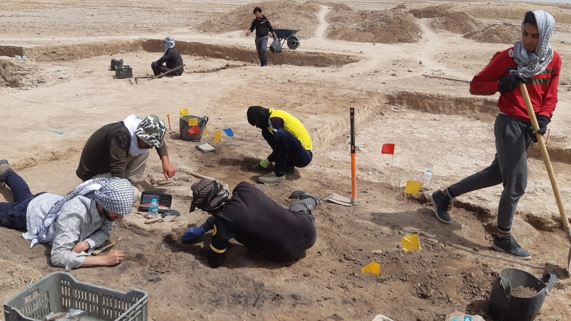
Archaeologists have confirmed the location of a lost city founded by Alexander the Great, a once-thriving trade hub that remained hidden for centuries.
The ancient city, known as Alexandria on the Tigris, lies in southern Iraq near the Persian Gulf. It was founded in the 4th century BC as a port connecting trade from India with Mesopotamia and the Mediterranean world. It fell into obscurity after the 3rd century AD when the course of the Tigris River changed.
In recent years, researchers have mapped the city’s fortification walls, road network, and building blocks thanks to drone imagery and high-resolution scans. Archaeologists have been working at the site since the 2010s, when ISIS controlled parts of Iraq, but only now has the full extent of the lost metropolis been revealed.
The University of Konstanz in Germany reported that excavators were “only allowed to conduct surface surveys under the close supervision of either soldiers or police.”
Researchers identified temple complexes, workshops, and kilns, as well as the remains of the city’s harbor and canal system.
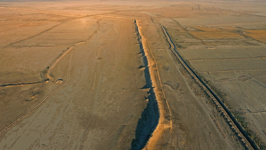
The city had been “repeatedly flooded” but remained preserved, said Stefan R. Hauser, professor of archaeology at the University of Konstanz.
Hauser told Fox News that, like its more famous counterpart in Egypt, Alexandria on the Tigris was founded at a crossroads between river and sea.
The city was established at a time when there was an urgent need for a new port in southern Mesopotamia to facilitate trade with India.
Hauser said Alexander the Great personally chose the site in 324 BC, citing the writer Pliny the Elder, who relied on earlier sources.
“The quality of the geophysical data is impressive… The preservation of the buildings is remarkably good,” he said.
Alexander the Great, who conquered the Persian Empire, reached the region because of its strategic position along the river.
The archaeologist said he was surprised by the size of the city, which covers 2.5 square miles, describing it as “enormous for an ancient city.”
“The size of the building blocks is exceptional,” he said. “It even surpasses those of major capitals of the time, such as Seleucia on the Tigris or Alexandria on the Nile.”
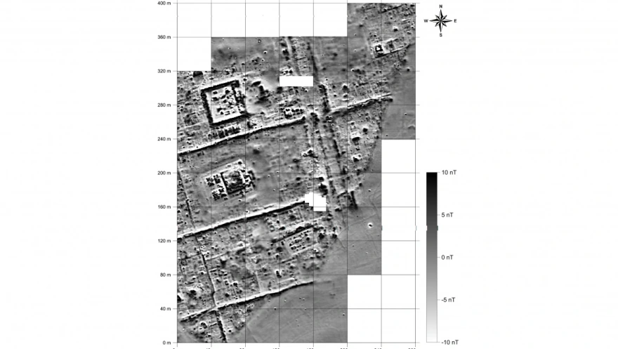
“The quality of the geophysical data is impressive… The condition of the buildings is surprisingly good, and we began identifying walls just beneath the surface, which also explains the strong results of the geophysical survey,” he added.
According to Hauser, the research began in 2016 under the leadership of British archaeologists Jane Moon, Robert Killick, and Stuart Campbell, whom he credited with initiating the project.
He said excavating the site has been “challenging,” since summer temperatures exceed 49°C and air pollution is intense.
The team plans to carry out excavations in the city’s residential districts, workshops, and kilns in the future if funding is secured.
Hauser emphasized that the site could shed new light on the Parthian Kingdom, which ruled the city centuries after Alexander the Great’s conquest. He described it as one of the least-studied powers of antiquity.
“There is not a single useful summary of its history, structure, and culture,” Hauser said. “The site is ideal for this kind of research, since no later construction activity has taken place there since antiquity.”
“We have the almost unique opportunity to reconstruct an entire urban plan through geophysical surveys, and we currently hope to complete them this year,” he added.
The conquest of the Persian Empire and the city’s founding
In the 4th century BC, Alexander the Great conquered the Achaemenid Persian Empire.
“Some participants in these campaigns left written accounts that provide us with fairly good, and sometimes even very detailed, information about Alexander’s military campaigns,” Hauser said.
While returning from the region of the Indus River to Mesopotamia, Alexander decided to use the river system to travel from Susa, the Achaemenid capital in present-day Iran, to Babylon.
He then discovered that southern Mesopotamia had been severely affected by sedimentation, the accumulation of fine mud transported across the Babylonian alluvial plain by the Tigris and especially by the canals connected to the Euphrates.
As a result, the Persian Gulf coastline kept extending outward into the sea, marshes formed, and traditional ports became harder to access or even lost their connection to the rivers as their courses shifted.
According to ancient authors, Alexander decided to establish a new port about two kilometers from the Gulf coast, at the confluence of the Karun and Tigris rivers. The new city, called Alexandria on the Tigris, thus linked the open sea with inland waterways to the north and east.
But how did the city — later known as Charax Spasinou or Charax of Maysan — develop in the following centuries? And how can we learn more about it today?
The discovery
The rediscovery of the city began in the 1960s with the doctoral dissertation of John Hansman, who studied changes in the river system between the time of Alexander the Great and the Mongol conquest. By studying Royal Air Force aerial photographs, he discovered an archaeological site enclosed by several kilometers of defensive walls.
The layout of the site and its fortifications reminded him of the way Pliny the Elder had described Alexandria in the 1st century AD. At the time, however, the idea went no further than his hypothesis and a brief visit to the site.
“The location was traditionally very difficult to access,” according to Hauser.
In addition to the fact that Alexandria’s peak coincided with a historical period long neglected in historical and archaeological research, the site lies only 15 kilometers from the Iranian border. During the Iran–Iraq War in the 1980s, the area became a major battlefield, and a military camp was built on the ruins of the ancient city.
It was not until 2013 that the three British archaeologists (Moon, Killick, and Campbell) traveled to the area. While working near the city of Ur, the director of the Basra Antiquities and Cultural Heritage Inspection asked whether they would like to visit and possibly work at another site: Jebel Khayaber.
The team agreed and traveled the 50 kilometers from Basra to the archaeological site in a tight convoy of heavily armored vehicles, following the security protocols in place at the time.
Researchers were especially impressed by the enormous dimensions of the fortification walls stretching for several kilometers and still reaching heights of eight meters today. On their return, they concluded that the vast but mostly flat ruins were the same site Hansman had identified.
In the spring of 2016, a British team carried out its first archaeological expedition there. A few months later they contacted Hauser, who joined the team, and the subsequent research ultimately concluded that the site is indeed Alexandria on the Tigris.
Ask me anything
Explore related questions




