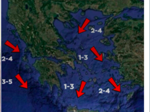






The transport of African dust continues and is expected to intensify today.
At the same time, temperatures will rise to nearly 8°C above normal for this time of year, reaching 26°C in eastern mainland Greece and Crete.
According to the forecast by protothema.gr meteorologist Giorgos Tsatrafyllias, Friday (13 November) will bring morning fog and localised rainfall, mainly in western Greece, the Peloponnese and the eastern Aegean. Isolated thunderstorms are also expected in western areas.
Temperatures will reach 25°C to 26°C in eastern mainland Greece and Crete. Conditions will be milder overnight and in the early morning. South-westerly winds will reach force 7 on the Beaufort scale in the Ionian Sea and force 8 in the Aegean.
In Attica, partly cloudy skies are expected, with a chance of scattered light showers carrying Saharan dust after midday. Temperatures will range from 14°C to 24°C, while south-westerly winds will reach force 7.
In Thessaloniki, partly cloudy conditions are forecast, with temperatures in the city reaching 24°C. Southerly winds in the Thermaic Gulf will reach force 5.
Weekend weather outlook
More widespread rainfall is expected on Saturday, particularly in western Greece.
Southerly winds will reach force 8 in the Aegean before gradually shifting to northerlies. Temperatures will remain close to 25°C in eastern mainland Greece and Crete, while African dust concentrations will begin to decline.
On Sunday, northerly winds will prevail, bringing a temporary drop in temperatures. A few localised showers are expected in eastern parts of the country.
Ask me anything
Explore related questions