The weather will remain a fire hazard today as winds will reach as high as 8 Beaufort.
According to the Fire Risk Prediction Map issued by the General Secretariat of Civil Protection of the Ministry of Climate Crisis & Civil Protection (www.civilprotection.gr), a very high fire risk (risk category 4) is predicted for today for the following areas:
Region of Attica (including the island of Kythera)
Region of Peloponnese (Region of Corinth, Region of Argolida, Region of Laconia)
Region of Crete
Region of North Aegean (Lesvos, Chios, Samos, Ikaria)
Region of South Aegean (Cyclades)
Region of Central Greece (Boeotia, Fthiotida, Evia)
Therefore, the 2nd stage of the operational readiness of the P.S. remains in place and air surveillance patrols will be carried out, as well as patrols by Fire, Police and Military forces.
In addition, the personnel of the Fire Services of the above Regional Units remain on partial alert, in order to cope with the increased service requirements that may arise due to the very high fire risk (risk category 4).
At the same time, for the above areas, the Civil Protection Action Plan for dealing with forest fire risks is being implemented, according to which, among other things, the implementation of the measure of preventive prohibition of vehicle traffic and stay of excursionists in national parks, forests and “vulnerable” areas is foreseen.
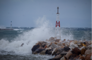
The wind gusted to 132 km/h yesterday in Paximada Karystos
Gusty winds were blowing from the early hours of Saturday 29/06 in the eastern mainland and the Aegean Sea, with gusts of northerly winds exceeding 100 km/h. According to the network of automatic meteorological stations of the National Observatory of Athens / meteo.gr yesterday the highest maximum wind gust was recorded in Paximada Karystos with 132 km/h, while the eight highest maximum gusts are presented in the following Table.
Today’s weather
Sunshine is forecast with a few clouds during the warm hours mainly in the mountains of Epirus and Western Macedonia and stronger winds in the Aegean and eastern mainland.
The temperature will range from 21 to 36 degrees in Northern Greece (in Western Macedonia from 16 to 32 degrees), 22 to 33 degrees in Central and Southern Greece (in Thessaly up to 36 degrees), 22 to 37 degrees in Western Greece, 21 to 30 degrees in the Cyclades and Crete, 24 to 35 degrees in the East Aegean islands and the Dodecanese.
The winds will blow in the North Aegean from northeastern directions moderate 4-5 Beaufort and in the rest of the Aegean from northern directions strong to almost gale force 6-7 Beaufort, with gradual weakening from the afternoon, while in the Ionian Sea from variable directions weak and occasionally almost moderate up to 4 Beaufort.
NOTICE FOR TOMORROW MONDAY 01-07-2024
Generally clear weather, with a few occasional clouds in the highlands of the mainland in the afternoon and afternoon.
Winds will be in the west variable light and gradually west northwest winds up to 4 Beaufort. In the east will blow from northerly directions 3 to 5, in the Aegean up to 6 and locally in the southeast occasionally 7 Beaufort.
The temperature will not change significantly and will reach 33 to 36 degrees Celsius on the mainland and 37 to 38 degrees Celsius in some places in the west and central regions, while in the islands 29 to 32 degrees Celsius and 32 to 34 degrees Celsius in some places in the eastern Aegean.
TUESDAY 02-07-2024
In the west, the central and the north, thin clouds are predicted, which will initially in the northwest and from noon onwards will become denser in the remaining parts and there will be local showers and in the central and northern parts isolated thunderstorms. From late afternoon in most areas the weather will improve and only in Macedonia will remain unstable with local showers and thunderstorms.
In the rest of the country the weather will be generally clear with sparse clouds.
Winds in the west will blow from southern directions 3 to 5 Beaufort. In the east will blow from the north 3 to 5 Beaufort and in the southeastern Aegean Sea occasionally locally 6 Beaufort, gradually turning to west southwest with the same intensity.
Meteorological conditions favour the transport of African dust to the west and south.
The temperature will remain at the same level and will reach 33 to 36 degrees Celsius on the mainland and 37 to 38 degrees Celsius in some places in the central part of the country, while on the islands it will reach 30 to 33 degrees Celsius.
WEDNESDAY 03-07-2024
In Macedonia and Thrace, unstable weather is forecast, with local rain and isolated thunderstorms mainly in the early morning and again in the midday and afternoon hours.
In the rest of the country, generally clear weather, with a few clouds, partly increasing in the mainland at noon and in the afternoon, when in the western mainly mountainous areas, there is a possibility of local rain or rain showers.
Winds in the west and south will blow from westerly directions 3 to 5 and gradually in the south locally up to 6 Beaufort. In the east it will blow from southerly directions 3 to 5 Beaufort and only in the northeast it will be east northeasterly with the same intensity.
Meteorological conditions favour the transport of African dust to the south.
The temperature is falling from the west.
THURSDAY 04-07-2024
In the eastern island country generally clear weather with local clouds. In the rest of the country the weather will be unsettled, with local showers and in the mainland sporadic thunderstorms, with improvement in the evening in the west.
Winds in the west and south will blow from westerly directions 3 to 5 and in the south locally up to 6 Beaufort. In the east it will blow south southeast 3 to 5 Beaufort and only in the northeast will be east northeast with the same intensity. From late afternoon in the north they will turn to northwest and strengthen.
The temperature will drop slightly further.
Ask me anything
Explore related questions