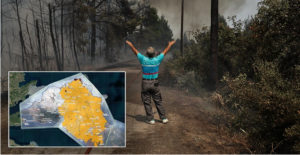
The photo published by the satellite service Copernicus/Emergency Management Service – Mapping of the European Union and shows the extent of the fire in Evia is shocking.
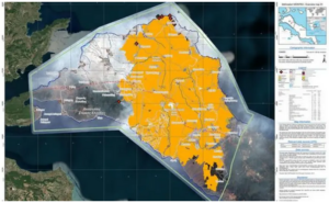
The European satellite recording system EFFIS determines that the burned area in Northern Evia is 507,950 acres, while it estimates that it can reach 700,000.
This is the greatest destruction of all time in Greece by a single fire.
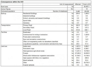
The EFFIS system determined the burned area on the borders of Ilia-Arcadia (it started from Ancient Olympia and burns Gortynia) to 150,150 acres, which is the second largest disaster by fires in our country this summer so far.
The fire that burned Laconia (in the wider area of Gythio) follows with 111,120 burned acres and in the fourth place is the fiery blaze in Attica that destroyed a total of 84,540 acres of forest.
The Copernicus/Emergency Management Service – Mapping of the European Union activated on August 3rd for the mapping of the areas of Attica and Evia affected by forest fires.
25 years to the day: Remembering Tassos Isaac & Solomos Solomou (videos-photos)
Ask me anything
Explore related questions


